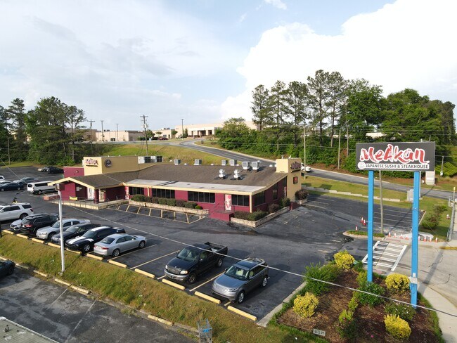
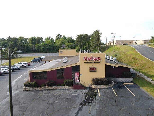
Property Record
1992 Watson Blvd, Warner Robins, GA 31093

Save to a Folder
{{folder.Name}}
{{folder.ListingIds.length}} Properties
{{folder.ListingIds.length}} Property
Create a New Folder
Property Detail
1992 Watson Blvd
0W069A006000
PT TRACT 1 & PT 1-A 2.613 ACRES 165/5TH
Restaurantbuilding
HOUSTON
C2
Georgia
B and X Area of moderate flood hazard, usually the area between the limits of the 100-year and 500-year floods.
165
2025
2.61 AC
2025
Perry/Warner Robins
020200
Other Market Areas
9,756 SF
Warner Robins, GA
NEARBY LISTINGS FOR SALE OR LEASE
DEMOGRAPHICS near 1992 Watson Blvd
1 mile
3 mile
5 mile
2025 Total Population
7,411
64,287
113,014
2030 Population
7,725
67,777
118,941
Pop Growth 2025-2030
+ 4.24%
+ 5.43%
+ 5.24%
Average Age
39
38
38
2025 Total Households
3,082
26,022
44,394
HH Growth 2025-2030
+ 4.28%
+ 5.47%
+ 5.30%
Median Household Inc
$64,897
$55,105
$66,848
Avg Household Size
2.30
2.40
2.50
2025 Avg HH Vehicles
2.00
2.00
2.00
Median Home Value
$167,435
$145,895
$184,758
Median Year Built
1972
1979
1990
Nearby Places
Map Layers
Map Styles
 Street
 Aerial
Layers
 Traffic
 Biking
Places
Listings with unknown addresses are not visible on the map
- Restaurants
- Banks
- Shops
- Fitness
- Groceries
SALE & LEASE HISTORY
LISTING DATE
SALE/LEASE

Sep 25, 2016
For Lease
Sep 23, 2016
For Sale
Nov 21, 2020
For Sale
Jun 06, 2022
For Sale
Dec 21, 2016
For Sale
Dec 09, 2020
For Sale
Nearby Properties
Address
Land Use
TOTAL SIZE
Lot Size
Zoning
Address
Land Use
TOTAL SIZE
Lot Size
Zoning
37,908 SF
19.79 AC
C2
Address
Land Use
TOTAL SIZE
Lot Size
Zoning
3,960 SF
22.93 AC
R4
Address
Land Use
TOTAL SIZE
Lot Size
Zoning
88,965 SF
18.72 AC
R2
Address
Land Use
TOTAL SIZE
Lot Size
Zoning
5,640 SF
24 AC
C2
Address
Land Use
TOTAL SIZE
Lot Size
Zoning
26,271 SF
17.43 AC
C2
Address
Land Use
TOTAL SIZE
Lot Size
Zoning
21,476 SF
17.41 AC
R4
Address
Land Use
TOTAL SIZE
Lot Size
Zoning
84,544 SF
35.44 AC
R4
Address
Land Use
TOTAL SIZE
Lot Size
Zoning
488,964 SF
49.90 AC
C2
Address
Land Use
TOTAL SIZE
Lot Size
Zoning
94,820 SF
18.66 AC
C2
Address
Land Use
TOTAL SIZE
Lot Size
Zoning
223,599 SF
22.40 AC
C2
Address
Land Use
TOTAL SIZE
Lot Size
Zoning
11,658 SF
30.23 AC
R2
Address
Land Use
TOTAL SIZE
Lot Size
Zoning
2,551 SF
17.38 AC
R4 C2
Address
Land Use
TOTAL SIZE
Lot Size
Zoning
218,304 SF
47.18 AC
C2
Address
Land Use
TOTAL SIZE
Lot Size
Zoning
2,080 SF
15.62 AC
R4
Address
Land Use
TOTAL SIZE
Lot Size
Zoning
304,246 SF
23.11 AC
C2
Address
Land Use
TOTAL SIZE
Lot Size
Zoning
132,850 SF
24.05 AC
C2
Address
Land Use
TOTAL SIZE
Lot Size
Zoning
234,239 SF
24.71 AC
C2
Address
Land Use
TOTAL SIZE
Lot Size
Zoning
164,700 SF
19.20 AC
R3
Address
Land Use
TOTAL SIZE
Lot Size
Zoning
178,400 SF
49.03 AC
R2
Address
Land Use
TOTAL SIZE
Lot Size
Zoning
76,751 SF
26.32 AC
R1
Address
Land Use
TOTAL SIZE
Lot Size
Zoning
125,550 SF
9.82 AC
C2
Address
Land Use
TOTAL SIZE
Lot Size
Zoning
2,231 SF
11.48 AC
C2
Address
Land Use
TOTAL SIZE
Lot Size
Zoning
23,440 SF
18.96 AC
C2
Address
Land Use
TOTAL SIZE
Lot Size
Zoning
78,270 SF
3.35 AC
C2
Address
Land Use
TOTAL SIZE
Lot Size
Zoning
108,750 SF
10.85 AC
C2
Address
Land Use
TOTAL SIZE
Lot Size
Zoning
32,739 SF
2.53 AC
C2
Address
Land Use
TOTAL SIZE
Lot Size
Zoning
1,531 SF
27.16 AC
R4
Address
Land Use
TOTAL SIZE
Lot Size
Zoning
14,096 SF
14.12 AC
R4
Address
Land Use
TOTAL SIZE
Lot Size
Zoning
22,112 SF
14.70 AC
R4
Address
Land Use
TOTAL SIZE
Lot Size
Zoning
26,928 SF
5.74 AC
R4
The World's #1 Commercial Real Estate Marketplace
Connect with us
© 2026 CoStar Group
The information above has been obtained from sources believed reliable. While we do not doubt its accuracy we have not verified it and make no guarantee, warranty or representation about it. It is your responsibility to independently confirm its accuracy and completeness. Any projections, opinions, assumptions, or estimates used are for example only and do not represent the current or future performance of the property. The value of this transaction to you depends on tax and other factors which should be evaluated by your tax, financial, and legal advisors. You and your advisors should conduct a careful, independent investigation of the property to determine to your satisfaction the suitability of the property for your needs.