No Photo
Property Record
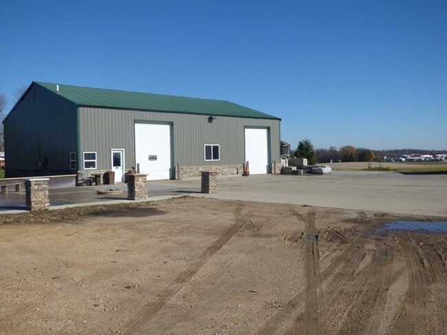
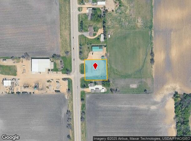
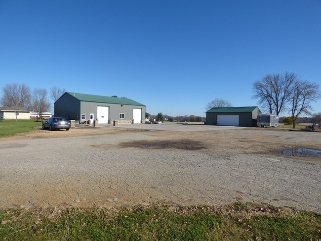
19947 State Highway 22, Mankato, MN 56001
NEARBY LISTINGS FOR SALE OR LEASE
-
-
No Photo
-
View all Mankato listings for sale on LoopNet.com
Property Detail
19947 State Highway 22
Mankato, MN
Roberts
R43-09-33-201-006
N182.5' OF S307.5' OF W200' OF NW4 OF NE4 033 108 26 000.840A 000.840A
Commercialacreage
Blue Earth
X
Minnesota
27013C0227F
0.84 AC
2025
Minnesota South Area
2025
Other Market Areas
171300
DEMOGRAPHICS near 19947 State Highway 22
1 Mile
3 Mile
5 Mile
2024 Total Population
147
24,442
55,954
2029 Population
152
25,078
57,112
Pop Growth 2024-2029
+ 3.40%
+ 2.60%
+ 2.07%
Average Age
38
34
36
2024 Total Households
54
9,190
22,136
HH Growth 2024-2029
+ 3.70%
+ 2.77%
+ 2.18%
Median Household Inc
$85,416
$62,663
$64,583
Avg Household Size
2.50
2.40
2.30
2024 Avg HH Vehicles
2.00
2.00
2.00
Median Home Value
$290,908
$242,235
$217,398
Median Year Built
2003
1994
1979
Nearby Places
Map Layers
Map Styles
 Street
 Aerial
- Restaurants
- Banks
- Shops
- Fitness
- Groceries
Nearby Properties
Address
Land Use
TOTAL SIZE
Lot Size
Zoning
Address
Land Use
TOTAL SIZE
Lot Size
Zoning
178,201 SF
64.49 AC
Address
Land Use
TOTAL SIZE
Lot Size
Zoning
12.37 AC
Address
Land Use
TOTAL SIZE
Lot Size
Zoning
17.90 AC
Address
Land Use
TOTAL SIZE
Lot Size
Zoning
13.43 AC
Address
Land Use
TOTAL SIZE
Lot Size
Zoning
11.75 AC
Address
Land Use
TOTAL SIZE
Lot Size
Zoning
287,085 SF
38 AC
Address
Land Use
TOTAL SIZE
Lot Size
Zoning
101,602 SF
20 AC
Address
Land Use
TOTAL SIZE
Lot Size
Zoning
157,216 SF
31.67 AC
Address
Land Use
TOTAL SIZE
Lot Size
Zoning
4.26 AC
Address
Land Use
TOTAL SIZE
Lot Size
Zoning
5.67 AC
Address
Land Use
TOTAL SIZE
Lot Size
Zoning
144,504 SF
3.87 AC
Address
Land Use
TOTAL SIZE
Lot Size
Zoning
6.44 AC
Address
Land Use
TOTAL SIZE
Lot Size
Zoning
Address
Land Use
TOTAL SIZE
Lot Size
Zoning
Address
Land Use
TOTAL SIZE
Lot Size
Zoning
3.57 AC
Address
Land Use
TOTAL SIZE
Lot Size
Zoning
3.57 AC
Address
Land Use
TOTAL SIZE
Lot Size
Zoning
117,571 SF
17.45 AC
Address
Land Use
TOTAL SIZE
Lot Size
Zoning
Address
Land Use
TOTAL SIZE
Lot Size
Zoning
7.76 AC
Address
Land Use
TOTAL SIZE
Lot Size
Zoning
3.50 AC
Address
Land Use
TOTAL SIZE
Lot Size
Zoning
66,720 SF
4.01 AC
Address
Land Use
TOTAL SIZE
Lot Size
Zoning
25,223 SF
2.98 AC
Address
Land Use
TOTAL SIZE
Lot Size
Zoning
14,407 SF
0.95 AC
Address
Land Use
TOTAL SIZE
Lot Size
Zoning
1,200 SF
33.96 AC
Address
Land Use
TOTAL SIZE
Lot Size
Zoning
5.60 AC
Address
Land Use
TOTAL SIZE
Lot Size
Zoning
2.36 AC
Address
Land Use
TOTAL SIZE
Lot Size
Zoning
7.74 AC
Address
Land Use
TOTAL SIZE
Lot Size
Zoning
3,862 SF
32.54 AC
Address
Land Use
TOTAL SIZE
Lot Size
Zoning
3.62 AC
The World's #1 Commercial Real Estate Marketplace
Connect with us
© 2026 CoStar Group
The information above has been obtained from sources believed reliable. While we do not doubt its accuracy we have not verified it and make no guarantee, warranty or representation about it. It is your responsibility to independently confirm its accuracy and completeness. Any projections, opinions, assumptions, or estimates used are for example only and do not represent the current or future performance of the property. The value of this transaction to you depends on tax and other factors which should be evaluated by your tax, financial, and legal advisors. You and your advisors should conduct a careful, independent investigation of the property to determine to your satisfaction the suitability of the property for your needs.