Property Record
1995 Dawsonville Hwy, Gainesville, GA 30501
NEARBY LISTINGS FOR SALE OR LEASE
Property Detail
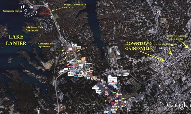
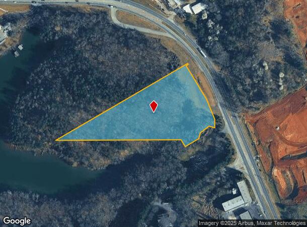
1995 Dawsonville Hwy
Gainesville, GA
DAWSONVILLE HIGHWAY
01-0110A-03-003
Hall
Commercialacreage
Georgia
A
103
13139C0180G
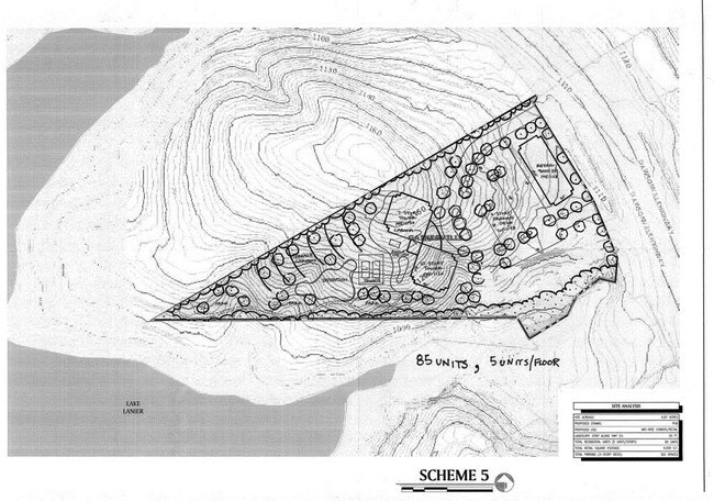
6.87 AC
2025
Gainesville/Hall County
2025
Atlanta
000901
DEMOGRAPHICS near 1995 Dawsonville Hwy
1 Mile
3 Mile
5 Mile
2024 Total Population
2,884
33,068
78,766
2029 Population
3,174
36,598
87,279
Pop Growth 2024-2029
+ 10.06%
+ 10.67%
+ 10.81%
Average Age
37
38
38
2024 Total Households
1,289
12,166
27,989
HH Growth 2024-2029
+ 9.85%
+ 10.64%
+ 10.80%
Median Household Inc
$58,768
$57,781
$59,981
Avg Household Size
2.20
2.60
2.70
2024 Avg HH Vehicles
2.00
2.00
2.00
Median Home Value
$406,296
$344,380
$286,444
Median Year Built
1995
1987
1988
Nearby Places
Map Layers
Map Styles
 Street
 Aerial
- Restaurants
- Banks
- Shops
- Fitness
- Groceries
PUBLIC TRANSPORTATION
COMMUTER RAIL
Gainesville Amtrak Station (Crescent - Amtrak)
DRIVE
WALK
Distance
Gainesville Amtrak Station (Crescent - Amtrak)
6 min
4.3 mi
Freight Ports
Georgia Ports - Savannah
DRIVE
WALK
Distance
Georgia Ports - Savannah
322 min
254.6 mi
SALE & LEASE HISTORY
LISTING DATE
SALE/LEASE

Sep 24, 2016
For Sale
Nearby Properties
Address
Land Use
TOTAL SIZE
Lot Size
Zoning
Address
Land Use
TOTAL SIZE
Lot Size
Zoning
66,720 SF
27.49 AC
PUD
Address
Land Use
TOTAL SIZE
Lot Size
Zoning
157,050 SF
144.96 AC
N-B
Address
Land Use
TOTAL SIZE
Lot Size
Zoning
27,221 SF
2.23 AC
G-B
Address
Land Use
TOTAL SIZE
Lot Size
Zoning
2,160 SF
5.60 AC
PUD
Address
Land Use
TOTAL SIZE
Lot Size
Zoning
58,020 SF
3.15 AC
PUD
Address
Land Use
TOTAL SIZE
Lot Size
Zoning
3,620 SF
20.20 AC
PUD
Address
Land Use
TOTAL SIZE
Lot Size
Zoning
100,864 SF
4.10 AC
PUD
Address
Land Use
TOTAL SIZE
Lot Size
Zoning
41,471 SF
27.60 AC
G-B/R-1
Address
Land Use
TOTAL SIZE
Lot Size
Zoning
19,875 SF
19.76 AC
R-B
Address
Land Use
TOTAL SIZE
Lot Size
Zoning
163,951 SF
19.10 AC
AR-1
Address
Land Use
TOTAL SIZE
Lot Size
Zoning
56,780 SF
16.78 AC
PUD
Address
Land Use
TOTAL SIZE
Lot Size
Zoning
76,726 SF
0.42 AC
C-B
Address
Land Use
TOTAL SIZE
Lot Size
Zoning
132,557 SF
32.85 AC
O-I
Address
Land Use
TOTAL SIZE
Lot Size
Zoning
11,430 SF
38 AC
R-I
Address
Land Use
TOTAL SIZE
Lot Size
Zoning
128,531 SF
13.32 AC
R-I
Address
Land Use
TOTAL SIZE
Lot Size
Zoning
54,720 SF
32.52 AC
R-II
Address
Land Use
TOTAL SIZE
Lot Size
Zoning
1,441 SF
10.46 AC
PUD
Address
Land Use
TOTAL SIZE
Lot Size
Zoning
123,944 SF
13.21 AC
G-B
Address
Land Use
TOTAL SIZE
Lot Size
Zoning
113,288 SF
46.89 AC
AR-1
Address
Land Use
TOTAL SIZE
Lot Size
Zoning
1,628 SF
10.41 AC
PUD
Address
Land Use
TOTAL SIZE
Lot Size
Zoning
60,062 SF
0.51 AC
C-B
Address
Land Use
TOTAL SIZE
Lot Size
Zoning
67,383 SF
1.68 AC
C-B
Address
Land Use
TOTAL SIZE
Lot Size
Zoning
231,966 SF
0.95 AC
C-B
Address
Land Use
TOTAL SIZE
Lot Size
Zoning
12,200 SF
0.30 AC
C-B
Address
Land Use
TOTAL SIZE
Lot Size
Zoning
24,097 SF
1.85 AC
C-B
Address
Land Use
TOTAL SIZE
Lot Size
Zoning
16,388 SF
5.16 AC
N-B
Address
Land Use
TOTAL SIZE
Lot Size
Zoning
1,558 SF
2.53 AC
L-I
Address
Land Use
TOTAL SIZE
Lot Size
Zoning
168,924 SF
0.62 AC
C-B
Address
Land Use
TOTAL SIZE
Lot Size
Zoning
6,062 SF
17.54 AC
R-I
Address
Land Use
TOTAL SIZE
Lot Size
Zoning
37,632 SF
8.52 AC
R-II
The World's #1 Commercial Real Estate Marketplace
Connect with us
© 2026 CoStar Group
The information above has been obtained from sources believed reliable. While we do not doubt its accuracy we have not verified it and make no guarantee, warranty or representation about it. It is your responsibility to independently confirm its accuracy and completeness. Any projections, opinions, assumptions, or estimates used are for example only and do not represent the current or future performance of the property. The value of this transaction to you depends on tax and other factors which should be evaluated by your tax, financial, and legal advisors. You and your advisors should conduct a careful, independent investigation of the property to determine to your satisfaction the suitability of the property for your needs.