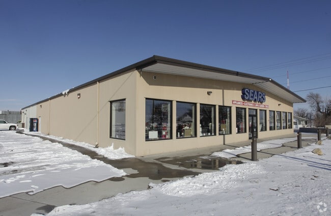
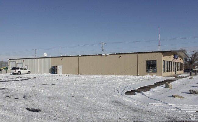
Property Record
1995 E Platte Ave, Fort Morgan, CO 80701

Property Detail
1995 E Platte Ave
R010635
S 05 T 3 R 57 PARC NE14 230FT X 230FT IN SE CORNER EX 746 P381 B1121 P136 & 881476
Storebuilding
MORGAN
B and X Area of moderate flood hazard, usually the area between the limits of the 100-year and 500-year floods.
Colorado
2025
1.21 AC
2024
Colorado East Area
000600
Other Market Areas
19,222 SF
Fort Morgan, CO
NEARBY LISTINGS FOR SALE OR LEASE
DEMOGRAPHICS near 1995 E Platte Ave
1 mile
3 mile
5 mile
2025 Total Population
2,565
13,697
16,366
2030 Population
2,687
14,317
17,138
Pop Growth 2025-2030
+ 4.76%
+ 4.53%
+ 4.72%
Average Age
40
37
37
2025 Total Households
971
4,801
5,772
HH Growth 2025-2030
+ 5.05%
+ 4.79%
+ 4.97%
Median Household Inc
$55,811
$71,046
$76,160
Avg Household Size
2.50
2.70
2.70
2025 Avg HH Vehicles
2.00
2.00
2.00
Median Home Value
$323,494
$292,572
$315,867
Median Year Built
1967
1969
1971
Nearby Places
Map Layers
Map Styles
 Street
 Aerial
Transit
 Traffic
 Biking
Places
Listings with unknown addresses are not visible on the map
- Restaurants
- Banks
- Shops
- Fitness
- Groceries
PUBLIC TRANSPORTATION
COMMUTER RAIL
Fort Morgan Amtrak Station (California Zephyr - Amtrak)
Drive
Walk
Distance
Fort Morgan Amtrak Station (California Zephyr - Amtrak)
4 min
2.1 mi
Freight Ports
Tulsa Port Of Catoosa
Drive
Walk
Distance
Tulsa Port Of Catoosa
741 min
685.7 mi
Nearby Properties
Address
Land Use
TOTAL SIZE
Lot Size
Zoning
Address
Land Use
TOTAL SIZE
Lot Size
Zoning
115,926 SF
20.77 AC
Address
Land Use
TOTAL SIZE
Lot Size
Zoning
78,079 SF
4.28 AC
Address
Land Use
TOTAL SIZE
Lot Size
Zoning
250,788 SF
32.30 AC
Address
Land Use
TOTAL SIZE
Lot Size
Zoning
171,427 SF
36.48 AC
Address
Land Use
TOTAL SIZE
Lot Size
Zoning
62,571 SF
9.72 AC
Address
Land Use
TOTAL SIZE
Lot Size
Zoning
188,771 SF
14.40 AC
Address
Land Use
TOTAL SIZE
Lot Size
Zoning
156,257 SF
22.81 AC
Address
Land Use
TOTAL SIZE
Lot Size
Zoning
55,306 SF
0.01 AC
Address
Land Use
TOTAL SIZE
Lot Size
Zoning
59,690 SF
3.40 AC
Address
Land Use
TOTAL SIZE
Lot Size
Zoning
32,385 SF
6.68 AC
Address
Land Use
TOTAL SIZE
Lot Size
Zoning
2,389 SF
60.20 AC
Address
Land Use
TOTAL SIZE
Lot Size
Zoning
11,554 SF
14.79 AC
Address
Land Use
TOTAL SIZE
Lot Size
Zoning
53,668 SF
1.34 AC
Address
Land Use
TOTAL SIZE
Lot Size
Zoning
93,695 SF
9.83 AC
Address
Land Use
TOTAL SIZE
Lot Size
Zoning
46,779 SF
11.09 AC
Address
Land Use
TOTAL SIZE
Lot Size
Zoning
90,286 SF
2.06 AC
Address
Land Use
TOTAL SIZE
Lot Size
Zoning
32,376 SF
6.93 AC
Address
Land Use
TOTAL SIZE
Lot Size
Zoning
42,654 SF
2.49 AC
Address
Land Use
TOTAL SIZE
Lot Size
Zoning
119,830 SF
4.87 AC
Address
Land Use
TOTAL SIZE
Lot Size
Zoning
21,544 SF
2.34 AC
Address
Land Use
TOTAL SIZE
Lot Size
Zoning
45,337 SF
6.92 AC
Address
Land Use
TOTAL SIZE
Lot Size
Zoning
42,234 SF
7.09 AC
Address
Land Use
TOTAL SIZE
Lot Size
Zoning
39,203 SF
2 AC
Address
Land Use
TOTAL SIZE
Lot Size
Zoning
36,422 SF
2.39 AC
Address
Land Use
TOTAL SIZE
Lot Size
Zoning
14,487 SF
1.10 AC
Address
Land Use
TOTAL SIZE
Lot Size
Zoning
49,564 SF
2 AC
Address
Land Use
TOTAL SIZE
Lot Size
Zoning
39,280 SF
2.06 AC
Address
Land Use
TOTAL SIZE
Lot Size
Zoning
362,981 SF
16.57 AC
Address
Land Use
TOTAL SIZE
Lot Size
Zoning
44,790 SF
8.65 AC
Address
Land Use
TOTAL SIZE
Lot Size
Zoning
12,670 SF
1.12 AC
The World's #1 Commercial Real Estate Marketplace
Connect with us
© 2026 CoStar Group
The information above has been obtained from sources believed reliable. While we do not doubt its accuracy we have not verified it and make no guarantee, warranty or representation about it. It is your responsibility to independently confirm its accuracy and completeness. Any projections, opinions, assumptions, or estimates used are for example only and do not represent the current or future performance of the property. The value of this transaction to you depends on tax and other factors which should be evaluated by your tax, financial, and legal advisors. You and your advisors should conduct a careful, independent investigation of the property to determine to your satisfaction the suitability of the property for your needs.