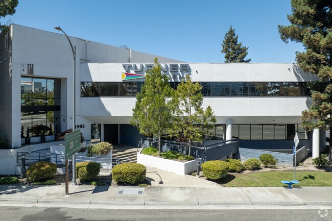
Property Record
1995 N 1St St, San Jose, CA 95112


Current Lease Availabilities
Property Detail
1995 N 1St St
Financialbuilding
Santa Clara
CN
California
AO River or stream flood hazard areas, and areas with a 1% or greater chance of shallow flooding each year. These areas have a 26% chance of flooding over the life of a 30-year mortgage.
0.93 AC
2024
North San Jose
2025
South Bay/San Jose
505006
San Jose-Sunnyvale-Santa Clara, CA
21,808 SF
101-06-003
NEARBY LISTINGS FOR SALE OR LEASE
DEMOGRAPHICS near 1995 N 1St St
1 mile
3 mile
5 mile
2025 Total Population
3,135
184,900
602,804
2030 Population
3,147
190,410
617,988
Pop Growth 2025-2030
+ 0.38%
+ 2.98%
+ 2.52%
Average Age
39
37
38
2025 Total Households
1,488
69,162
209,848
HH Growth 2025-2030
+ 0.27%
+ 3.19%
+ 2.72%
Median Household Inc
$120,833
$161,322
$146,256
Avg Household Size
2.10
2.50
2.70
2025 Avg HH Vehicles
1.00
2.00
2.00
Median Home Value
$944,871
$1,089,477
$1,077,820
Median Year Built
2001
1991
1978
Nearby Places
Map Layers
Map Styles
 Street
 Aerial
Layers
 Traffic
 Biking
Places
Listings with unknown addresses are not visible on the map
- Restaurants
- Banks
- Shops
- Fitness
- Groceries
PUBLIC TRANSPORTATION
TRANSIT/SUBWAY
Karina Station (Alum Rock - Santa Teresa Line - Santa Clara VTA Light Rail, Mountain View - Winchester Line - Santa Clara VTA Light Rail)
Drive
Walk
Distance
Karina Station (Alum Rock - Santa Teresa Line - Santa Clara VTA Light Rail, Mountain View - Winchester Line - Santa Clara VTA Light Rail)
2 min
4 min
0.2 mi
Metro/Airport Station (Alum Rock - Santa Teresa Line - Santa Clara VTA Light Rail, Mountain View - Winchester Line - Santa Clara VTA Light Rail)
Drive
Walk
Distance
Metro/Airport Station (Alum Rock - Santa Teresa Line - Santa Clara VTA Light Rail, Mountain View - Winchester Line - Santa Clara VTA Light Rail)
1 min
7 min
0.3 mi
Component Station (Alum Rock - Santa Teresa Line - Santa Clara VTA Light Rail, Mountain View - Winchester Line - Santa Clara VTA Light Rail)
Drive
Walk
Distance
Component Station (Alum Rock - Santa Teresa Line - Santa Clara VTA Light Rail, Mountain View - Winchester Line - Santa Clara VTA Light Rail)
2 min
16 min
0.8 mi
Gish Station (Alum Rock - Santa Teresa Line - Santa Clara VTA Light Rail, Mountain View - Winchester Line - Santa Clara VTA Light Rail)
Drive
Walk
Distance
Gish Station (Alum Rock - Santa Teresa Line - Santa Clara VTA Light Rail, Mountain View - Winchester Line - Santa Clara VTA Light Rail)
2 min
19 min
0.9 mi
COMMUTER RAIL
Drive
Walk
Distance
6 min
3.0 mi
Drive
Walk
Distance
7 min
4.1 mi
AIRPORT
Norman Y Mineta San Jose International
Drive
Walk
Distance
Norman Y Mineta San Jose International
7 min
3.6 mi
San Francisco International
Drive
Walk
Distance
San Francisco International
42 min
33.5 mi
Metro Oakland International
Drive
Walk
Distance
Metro Oakland International
43 min
33.8 mi
Freight Ports
Port of Redwood City
Drive
Walk
Distance
Port of Redwood City
27 min
20.3 mi
Nearby Properties
Address
Land Use
TOTAL SIZE
Lot Size
Zoning
Address
Land Use
TOTAL SIZE
Lot Size
Zoning
553,793 SF
38.06 AC
ML
Address
Land Use
TOTAL SIZE
Lot Size
Zoning
0.06 AC
PD
Address
Land Use
TOTAL SIZE
Lot Size
Zoning
238,239 SF
24.67 AC
PD
Address
Land Use
TOTAL SIZE
Lot Size
Zoning
576,892 SF
8.28 AC
APD
Address
Land Use
TOTAL SIZE
Lot Size
Zoning
360,000 SF
18.81 AC
MH
Address
Land Use
TOTAL SIZE
Lot Size
Zoning
636,145 SF
9.44 AC
IP
Address
Land Use
TOTAL SIZE
Lot Size
Zoning
74,528 SF
9.26 AC
TEC
Address
Land Use
TOTAL SIZE
Lot Size
Zoning
9.11 AC
ML
Address
Land Use
TOTAL SIZE
Lot Size
Zoning
194,790 SF
5.30 AC
APDCI
Address
Land Use
TOTAL SIZE
Lot Size
Zoning
837,391 SF
1.42 AC
DC
Address
Land Use
TOTAL SIZE
Lot Size
Zoning
2.99 AC
MH
Address
Land Use
TOTAL SIZE
Lot Size
Zoning
242,320 SF
8.01 AC
TEC
Address
Land Use
TOTAL SIZE
Lot Size
Zoning
208,562 SF
9.10 AC
CP
Address
Land Use
TOTAL SIZE
Lot Size
Zoning
281,574 SF
32.09 AC
IP
Address
Land Use
TOTAL SIZE
Lot Size
Zoning
50,774 SF
3.84 AC
MP
Address
Land Use
TOTAL SIZE
Lot Size
Zoning
320,000 SF
15.18 AC
APD
Address
Land Use
TOTAL SIZE
Lot Size
Zoning
556,649 SF
8.09 AC
IP
Address
Land Use
TOTAL SIZE
Lot Size
Zoning
104,960 SF
10.19 AC
IP
Address
Land Use
TOTAL SIZE
Lot Size
Zoning
500,000 SF
41.05 AC
MH
Address
Land Use
TOTAL SIZE
Lot Size
Zoning
605,915 SF
5.36 AC
APD
Address
Land Use
TOTAL SIZE
Lot Size
Zoning
130,306 SF
8.75 AC
ML
Address
Land Use
TOTAL SIZE
Lot Size
Zoning
2.99 AC
MH
Address
Land Use
TOTAL SIZE
Lot Size
Zoning
473,849 SF
6 AC
ML
Address
Land Use
TOTAL SIZE
Lot Size
Zoning
27,000 SF
2 AC
MH
Address
Land Use
TOTAL SIZE
Lot Size
Zoning
446,996 SF
5.24 AC
ML
Address
Land Use
TOTAL SIZE
Lot Size
Zoning
329,907 SF
3.94 AC
A(PD)
Address
Land Use
TOTAL SIZE
Lot Size
Zoning
486,104 SF
5.43 AC
ML
Address
Land Use
TOTAL SIZE
Lot Size
Zoning
12.40 AC
R3
Address
Land Use
TOTAL SIZE
Lot Size
Zoning
194,530 SF
12.26 AC
APD
Address
Land Use
TOTAL SIZE
Lot Size
Zoning
503,840 SF
5.02 AC
MXD2
The World's #1 Commercial Real Estate Marketplace
Connect with us
© 2026 CoStar Group
The information above has been obtained from sources believed reliable. While we do not doubt its accuracy we have not verified it and make no guarantee, warranty or representation about it. It is your responsibility to independently confirm its accuracy and completeness. Any projections, opinions, assumptions, or estimates used are for example only and do not represent the current or future performance of the property. The value of this transaction to you depends on tax and other factors which should be evaluated by your tax, financial, and legal advisors. You and your advisors should conduct a careful, independent investigation of the property to determine to your satisfaction the suitability of the property for your needs.