Property Record
1995 Richmond Rd, Williamsburg, VA 23185
Save to a Folder
{{folder.Name}}
{{folder.ListingIds.length}} Properties
{{folder.ListingIds.length}} Property
Create a New Folder
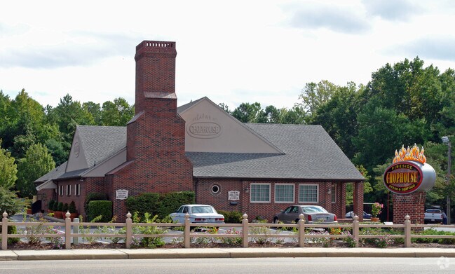
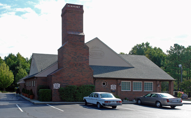
Property Detail
1995 Richmond Rd
Virginia Beach-Chesapeake-Norfolk, VA-NC
YORK
C16D-3762-2151
Virginia
Restaurantbuilding
1.48 AC
GENERAL BU
Williamsburg
B and X Area of moderate flood hazard, usually the area between the limits of the 100-year and 500-year floods.
Hampton Roads
4,878 SF
NEARBY LISTINGS FOR SALE OR LEASE
DEMOGRAPHICS near 1995 Richmond Rd
1 mile
3 mile
5 mile
2025 Total Population
5,564
39,706
79,595
2030 Population
5,824
41,356
82,595
Pop Growth 2025-2030
+ 4.67%
+ 4.16%
+ 3.77%
Average Age
41
41
44
2025 Total Households
2,526
15,780
32,150
HH Growth 2025-2030
+ 5.50%
+ 4.87%
+ 4.19%
Median Household Inc
$62,815
$81,045
$99,437
Avg Household Size
2.00
2.20
2.30
2025 Avg HH Vehicles
2.00
2.00
2.00
Median Home Value
$303,981
$396,069
$420,351
Median Year Built
1995
1995
1995
Nearby Places
Map Layers
Map Styles
 Street
 Aerial
Layers
 Traffic
 Biking
Places
Listings with unknown addresses are not visible on the map
- Restaurants
- Banks
- Shops
- Fitness
- Groceries
PUBLIC TRANSPORTATION
COMMUTER RAIL
Drive
Walk
Distance
8 min
2.2 mi
AIRPORT
Newport News/Williamsburg International
Drive
Walk
Distance
Newport News/Williamsburg International
34 min
20.8 mi
Richmond International
Drive
Walk
Distance
Richmond International
55 min
44.1 mi
Norfolk International
Drive
Walk
Distance
Norfolk International
65 min
46.9 mi
SALE & LEASE HISTORY
LISTING DATE
SALE/LEASE

Oct 14, 2020
For Sale
Jan 30, 2023
For Lease
Jan 30, 2023
For Sale
Nearby Properties
Address
Land Use
TOTAL SIZE
Lot Size
Zoning
Address
Land Use
TOTAL SIZE
Lot Size
Zoning
55,136 SF
348.94 AC
WM
Address
Land Use
TOTAL SIZE
Lot Size
Zoning
10,008 SF
83.06 AC
ECONOMIC O
Address
Land Use
TOTAL SIZE
Lot Size
Zoning
51,320 SF
B-3 (GENER
Address
Land Use
TOTAL SIZE
Lot Size
Zoning
87,083 SF
55.74 AC
WM (WILLIA
Address
Land Use
TOTAL SIZE
Lot Size
Zoning
88,000 SF
11.48 AC
MS (MUSEUM
Address
Land Use
TOTAL SIZE
Lot Size
Zoning
257 SF
105.86 AC
MU MIXED U
Address
Land Use
TOTAL SIZE
Lot Size
Zoning
104,404 SF
20.23 AC
PLANNED DE
Address
Land Use
TOTAL SIZE
Lot Size
Zoning
71,980 SF
6 AC
ED-2 (ECON
Address
Land Use
TOTAL SIZE
Lot Size
Zoning
263,288 SF
34.22 AC
MU MIXED U
Address
Land Use
TOTAL SIZE
Lot Size
Zoning
52,774 SF
9.07 AC
PLANNED DE
Address
Land Use
TOTAL SIZE
Lot Size
Zoning
625,352 SF
13.60 AC
MU MIXED U
Address
Land Use
TOTAL SIZE
Lot Size
Zoning
252,940 SF
54.18 AC
PL PUBLIC
Address
Land Use
TOTAL SIZE
Lot Size
Zoning
164,647 SF
33.87 AC
MS (MUSEUM
Address
Land Use
TOTAL SIZE
Lot Size
Zoning
109,045 SF
18.31 AC
RS-2 (SING
Address
Land Use
TOTAL SIZE
Lot Size
Zoning
55,122 SF
11.33 AC
LB-1 (DOWN
Address
Land Use
TOTAL SIZE
Lot Size
Zoning
491.07 AC
PL PUBLIC
Address
Land Use
TOTAL SIZE
Lot Size
Zoning
182,259 SF
3.60 AC
B-1 (DOWNT
Address
Land Use
TOTAL SIZE
Lot Size
Zoning
49,631 SF
15.58 AC
B1 GENERAL
Address
Land Use
TOTAL SIZE
Lot Size
Zoning
501.93 AC
WM (WILLIA
Address
Land Use
TOTAL SIZE
Lot Size
Zoning
3,465 SF
24.94 AC
R5 MULTIFA
Address
Land Use
TOTAL SIZE
Lot Size
Zoning
113,000 SF
22.20 AC
WM (WILLIA
Address
Land Use
TOTAL SIZE
Lot Size
Zoning
14,448 SF
6.94 AC
WM (WILLIA
Address
Land Use
TOTAL SIZE
Lot Size
Zoning
32,730 SF
4.89 AC
ED-2 (ECON
Address
Land Use
TOTAL SIZE
Lot Size
Zoning
2 SF
17.45 AC
R4 RESIDEN
Address
Land Use
TOTAL SIZE
Lot Size
Zoning
167,811 SF
51.70 AC
PUDR PLANN
Address
Land Use
TOTAL SIZE
Lot Size
Zoning
36,545 SF
11.31 AC
MS (MUSEUM
Address
Land Use
TOTAL SIZE
Lot Size
Zoning
190,936 SF
15.60 AC
R4 RESIDEN
Address
Land Use
TOTAL SIZE
Lot Size
Zoning
60,344 SF
11.41 AC
LB-4 (LIMI
Address
Land Use
TOTAL SIZE
Lot Size
Zoning
154,809 SF
7.31 AC
PLANNED DE
Address
Land Use
TOTAL SIZE
Lot Size
Zoning
12,444 SF
26.96 AC
RM-2 (MULT
The World's #1 Commercial Real Estate Marketplace
Connect with us
© 2026 CoStar Group
The information above has been obtained from sources believed reliable. While we do not doubt its accuracy we have not verified it and make no guarantee, warranty or representation about it. It is your responsibility to independently confirm its accuracy and completeness. Any projections, opinions, assumptions, or estimates used are for example only and do not represent the current or future performance of the property. The value of this transaction to you depends on tax and other factors which should be evaluated by your tax, financial, and legal advisors. You and your advisors should conduct a careful, independent investigation of the property to determine to your satisfaction the suitability of the property for your needs.