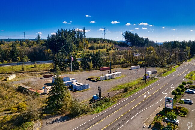
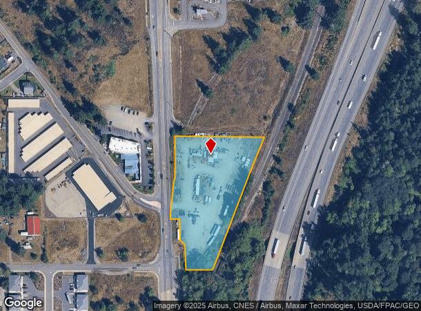
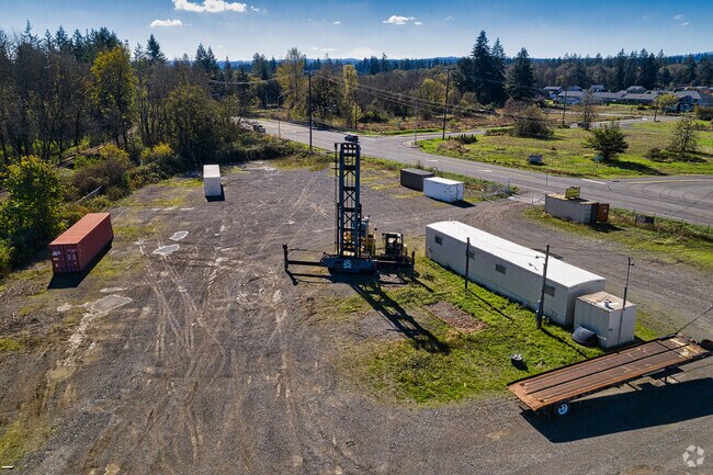
Property Record
19950 Old Highway 99 Sw, Rochester, WA 98579
Current Lease Availabilities
NEARBY LISTINGS FOR SALE OR LEASE
Property Detail
19950 Old Highway 99 Sw
13512320300
Jackson Fruit Tracts
Commercialnec
SECTION 12 TOWNSHIP 15 RANGE 3W QUARTER NW SW THAT PTN LYING S OF TR 28 JACKSON FRUIT TRACTS AS REC MARCH 13, 1911, UNDER AFN:51014, VOL 8 OF PLATS, PG 54, E OF OLD HWY 99, & W OF THE CHICAGO, ST
X
Thurston
53067C0445F
Washington
2024
2.59 AC
2024
Outlying Thurston County
012720
Olympia
960 SF
Olympia-Tumwater, WA
DEMOGRAPHICS near 19950 Old Highway 99 Sw
1 Mile
3 Mile
5 Mile
2024 Total Population
1,722
8,095
23,417
2029 Population
1,846
8,549
25,154
Pop Growth 2024-2029
+ 7.20%
+ 5.61%
+ 7.42%
Average Age
36
40
41
2024 Total Households
553
2,853
8,595
HH Growth 2024-2029
+ 7.05%
+ 5.64%
+ 7.63%
Median Household Inc
$77,092
$82,357
$75,420
Avg Household Size
3.00
2.80
2.60
2024 Avg HH Vehicles
3.00
3.00
2.00
Median Home Value
$301,887
$366,387
$370,615
Median Year Built
1999
1994
1992
Nearby Places
- Restaurants
- Banks
- Shops
- Fitness
- Groceries
PUBLIC TRANSPORTATION
COMMUTER RAIL
Centralia Amtrak Station (Amtrak Cascades - Amtrak, Coast Starlight - Amtrak)
DRIVE
WALK
Distance
Centralia Amtrak Station (Amtrak Cascades - Amtrak, Coast Starlight - Amtrak)
12 min
7.6 mi
Freight Ports
Port of Grays Harbor, WA
DRIVE
WALK
Distance
Port of Grays Harbor, WA
72 min
48.1 mi
Nearby Properties
Address
Land Use
TOTAL SIZE
Lot Size
Zoning
Address
Land Use
TOTAL SIZE
Lot Size
Zoning
441,608 SF
Address
Land Use
TOTAL SIZE
Lot Size
Zoning
32,914 SF
3.38 AC
PMP
Address
Land Use
TOTAL SIZE
Lot Size
Zoning
229,011 SF
209.52 AC
PID
Address
Land Use
TOTAL SIZE
Lot Size
Zoning
155,458 SF
15.79 AC
PMP
Address
Land Use
TOTAL SIZE
Lot Size
Zoning
738,962 SF
16.50 AC
Address
Land Use
TOTAL SIZE
Lot Size
Zoning
297,970 SF
19.32 AC
PID
Address
Land Use
TOTAL SIZE
Lot Size
Zoning
158,948 SF
77.13 AC
RRR1/5
Address
Land Use
TOTAL SIZE
Lot Size
Zoning
196,060 SF
24.68 AC
PMP
Address
Land Use
TOTAL SIZE
Lot Size
Zoning
23,908 SF
3.74 AC
AC
Address
Land Use
TOTAL SIZE
Lot Size
Zoning
22.44 AC
PMP
Address
Land Use
TOTAL SIZE
Lot Size
Zoning
768 SF
34.16 AC
PID
Address
Land Use
TOTAL SIZE
Lot Size
Zoning
1,728 SF
13.88 AC
RDD5
Address
Land Use
TOTAL SIZE
Lot Size
Zoning
12,616 SF
7.56 AC
AC
Address
Land Use
TOTAL SIZE
Lot Size
Zoning
36,262 SF
129.47 AC
RRR1/5
Address
Land Use
TOTAL SIZE
Lot Size
Zoning
28,248 SF
4.92 AC
PID
Address
Land Use
TOTAL SIZE
Lot Size
Zoning
4,997 SF
1.13 AC
AC
Address
Land Use
TOTAL SIZE
Lot Size
Zoning
3,848 SF
12.90 AC
R3-6/1
Address
Land Use
TOTAL SIZE
Lot Size
Zoning
10,672 SF
22.93 AC
RCC
Address
Land Use
TOTAL SIZE
Lot Size
Zoning
2,604 SF
6.85 AC
RRR1/5
Address
Land Use
TOTAL SIZE
Lot Size
Zoning
36,440 SF
1.92 AC
AC
Address
Land Use
TOTAL SIZE
Lot Size
Zoning
14,212 SF
4.37 AC
RCC
Address
Land Use
TOTAL SIZE
Lot Size
Zoning
34,916 SF
62.68 AC
RRR1/5
Address
Land Use
TOTAL SIZE
Lot Size
Zoning
23,941 SF
4.37 AC
PID
Address
Land Use
TOTAL SIZE
Lot Size
Zoning
4,320 SF
1.08 AC
AC
Address
Land Use
TOTAL SIZE
Lot Size
Zoning
115,874 SF
46.79 AC
RRR1/5
Address
Land Use
TOTAL SIZE
Lot Size
Zoning
36,262 SF
5.20 AC
Address
Land Use
TOTAL SIZE
Lot Size
Zoning
34,408 SF
7.21 AC
LI
Address
Land Use
TOTAL SIZE
Lot Size
Zoning
25,720 SF
2.25 AC
RL1/1
Address
Land Use
TOTAL SIZE
Lot Size
Zoning
8,423 SF
0.72 AC
AC
Address
Land Use
TOTAL SIZE
Lot Size
Zoning
9.86 AC
PID
The World's #1 Commercial Real Estate Marketplace
Connect with us
© 2025 CoStar Group
The information above has been obtained from sources believed reliable. While we do not doubt its accuracy we have not verified it and make no guarantee, warranty or representation about it. It is your responsibility to independently confirm its accuracy and completeness. Any projections, opinions, assumptions, or estimates used are for example only and do not represent the current or future performance of the property. The value of this transaction to you depends on tax and other factors which should be evaluated by your tax, financial, and legal advisors. You and your advisors should conduct a careful, independent investigation of the property to determine to your satisfaction the suitability of the property for your needs.