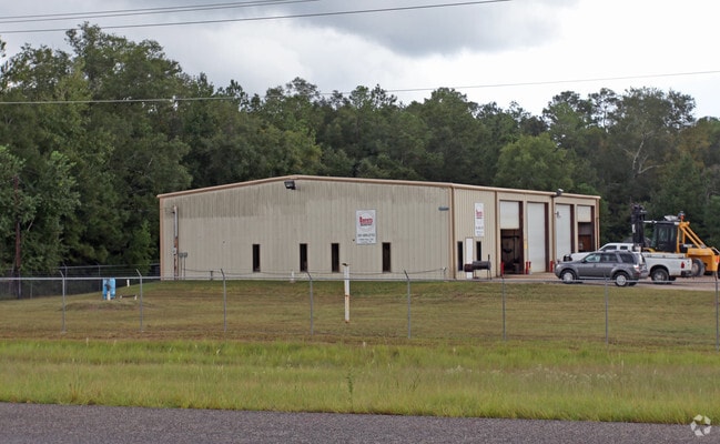
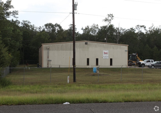
Property Record
19960 Highway 242, Conroe, TX 77306

Property Detail
19960 Highway 242
0419-00-04702
A0419 - PREWETT BEASLEY, TRACT 47-P, 47-M, ACRES 7.02
Commercialnec
Montgomery
AE The base floodplain where base flood elevations are provided. AE Zones are now used on new format FIRMs instead of A1-A30 Zones.
Texas
2024
7.02 AC
2025
The Woodlands/Conroe
692701
Houston
22,700 SF
Houston-Pasadena-The Woodlands, TX
NEARBY LISTINGS FOR SALE OR LEASE
DEMOGRAPHICS near 19960 Highway 242
1 mile
3 mile
5 mile
2025 Total Population
806
12,320
37,001
2030 Population
971
14,763
44,716
Pop Growth 2025-2030
+ 20.47%
+ 19.83%
+ 20.85%
Average Age
40
38
37
2025 Total Households
277
4,074
12,271
HH Growth 2025-2030
+ 21.30%
+ 20.64%
+ 21.42%
Median Household Inc
$53,000
$58,132
$72,256
Avg Household Size
2.80
2.90
3.00
2025 Avg HH Vehicles
2.00
2.00
2.00
Median Home Value
$319,231
$196,817
$233,718
Median Year Built
2010
2006
2009
Nearby Places
Map Layers
Map Styles
 Street
 Aerial
Layers
 Traffic
 Biking
Places
Listings with unknown addresses are not visible on the map
- Restaurants
- Banks
- Shops
- Fitness
- Groceries
PUBLIC TRANSPORTATION
AIRPORT
George Bush Intcntl/Houston
Drive
Walk
Distance
George Bush Intcntl/Houston
34 min
25.2 mi
Freight Ports
Port of Houston
Drive
Walk
Distance
Port of Houston
56 min
40.5 mi
Nearby Properties
Address
Land Use
TOTAL SIZE
Lot Size
Zoning
Address
Land Use
TOTAL SIZE
Lot Size
Zoning
1,500,000 SF
86.90 AC
5
Address
Land Use
TOTAL SIZE
Lot Size
Zoning
126,871 SF
58.54 AC
1
Address
Land Use
TOTAL SIZE
Lot Size
Zoning
137,928 SF
15.01 AC
Address
Land Use
TOTAL SIZE
Lot Size
Zoning
61,628 SF
30.91 AC
5
Address
Land Use
TOTAL SIZE
Lot Size
Zoning
65,640 SF
9.37 AC
Address
Land Use
TOTAL SIZE
Lot Size
Zoning
62,788 SF
4 AC
Address
Land Use
TOTAL SIZE
Lot Size
Zoning
96,946 SF
12 AC
1
Address
Land Use
TOTAL SIZE
Lot Size
Zoning
31,428 SF
17.52 AC
Address
Land Use
TOTAL SIZE
Lot Size
Zoning
45,120 SF
9.73 AC
Address
Land Use
TOTAL SIZE
Lot Size
Zoning
23,070 SF
10 AC
Address
Land Use
TOTAL SIZE
Lot Size
Zoning
26,558 SF
12 AC
1
Address
Land Use
TOTAL SIZE
Lot Size
Zoning
9,288 SF
1.99 AC
Address
Land Use
TOTAL SIZE
Lot Size
Zoning
24,800 SF
6.89 AC
Address
Land Use
TOTAL SIZE
Lot Size
Zoning
9,020 SF
1.54 AC
Address
Land Use
TOTAL SIZE
Lot Size
Zoning
9,180 SF
1.38 AC
1
Address
Land Use
TOTAL SIZE
Lot Size
Zoning
15,988 SF
46.22 AC
1
Address
Land Use
TOTAL SIZE
Lot Size
Zoning
19,939 SF
1.52 AC
1
Address
Land Use
TOTAL SIZE
Lot Size
Zoning
12,000 SF
1.38 AC
1
Address
Land Use
TOTAL SIZE
Lot Size
Zoning
9,280 SF
4.57 AC
1
Address
Land Use
TOTAL SIZE
Lot Size
Zoning
12,880 SF
5.86 AC
1
Address
Land Use
TOTAL SIZE
Lot Size
Zoning
8,050 SF
2.84 AC
1
Address
Land Use
TOTAL SIZE
Lot Size
Zoning
5,144 SF
2.41 AC
1
Address
Land Use
TOTAL SIZE
Lot Size
Zoning
16,800 SF
5.71 AC
Address
Land Use
TOTAL SIZE
Lot Size
Zoning
5,454 SF
19.11 AC
Address
Land Use
TOTAL SIZE
Lot Size
Zoning
7,344 SF
1.60 AC
1
Address
Land Use
TOTAL SIZE
Lot Size
Zoning
2,128 SF
15.06 AC
5
Address
Land Use
TOTAL SIZE
Lot Size
Zoning
8,109 SF
3.18 AC
Address
Land Use
TOTAL SIZE
Lot Size
Zoning
10,601 SF
7.73 AC
1
The World's #1 Commercial Real Estate Marketplace
Connect with us
© 2026 CoStar Group
The information above has been obtained from sources believed reliable. While we do not doubt its accuracy we have not verified it and make no guarantee, warranty or representation about it. It is your responsibility to independently confirm its accuracy and completeness. Any projections, opinions, assumptions, or estimates used are for example only and do not represent the current or future performance of the property. The value of this transaction to you depends on tax and other factors which should be evaluated by your tax, financial, and legal advisors. You and your advisors should conduct a careful, independent investigation of the property to determine to your satisfaction the suitability of the property for your needs.