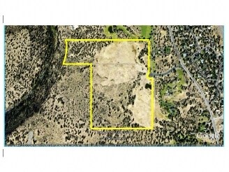
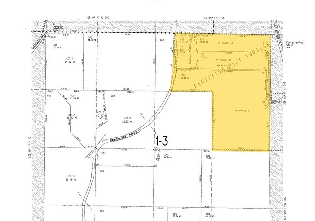
Property Record
19975 Destiny Ct, Bend, OR 97703

Property Detail
19975 Destiny Ct
113037
SEC 7- NW1/4NE1/4 LY E OF RIVER; E1/2NE1/4
Vacantlandnec
DESCHUTES
EFUTRB
Oregon
B and X Area of moderate flood hazard, usually the area between the limits of the 100-year and 500-year floods.
64.92 AC
2025
Deschutes County
2025
Portland
001102
Bend, OR
NEARBY LISTINGS FOR SALE OR LEASE
DEMOGRAPHICS near 19975 Destiny Ct
1 mile
3 mile
5 mile
2025 Total Population
458
15,671
64,418
2030 Population
464
15,991
65,976
Pop Growth 2025-2030
+ 1.31%
+ 2.04%
+ 2.42%
Average Age
43
42
41
2025 Total Households
169
5,932
26,525
HH Growth 2025-2030
+ 1.78%
+ 2.07%
+ 2.37%
Median Household Inc
$157,500
$122,509
$109,780
Avg Household Size
2.50
2.50
2.40
2025 Avg HH Vehicles
3.00
2.00
2.00
Median Home Value
$878,289
$837,801
$813,328
Median Year Built
1997
2002
1998
Nearby Places
Map Layers
Map Styles
 Street
 Aerial
Transit
 Traffic
 Biking
Places
Listings with unknown addresses are not visible on the map
- Restaurants
- Banks
- Shops
- Fitness
- Groceries
PUBLIC TRANSPORTATION
AIRPORT
Roberts Field
Drive
Walk
Distance
Roberts Field
21 min
15.0 mi
Freight Ports
Port of Portland
Drive
Walk
Distance
Port of Portland
226 min
173.8 mi
Nearby Properties
Address
Land Use
TOTAL SIZE
Lot Size
Zoning
Address
Land Use
TOTAL SIZE
Lot Size
Zoning
12,000 SF
2.77 AC
IL
Address
Land Use
TOTAL SIZE
Lot Size
Zoning
2.77 AC
IL
Address
Land Use
TOTAL SIZE
Lot Size
Zoning
7.99 AC
IL
Address
Land Use
TOTAL SIZE
Lot Size
Zoning
7.99 AC
IL
Address
Land Use
TOTAL SIZE
Lot Size
Zoning
317,867 SF
32.72 AC
CG
Address
Land Use
TOTAL SIZE
Lot Size
Zoning
229,286 SF
17.96 AC
CG
Address
Land Use
TOTAL SIZE
Lot Size
Zoning
70,294 SF
17.96 AC
CG
Address
Land Use
TOTAL SIZE
Lot Size
Zoning
24.36 AC
Address
Land Use
TOTAL SIZE
Lot Size
Zoning
24.36 AC
IG
Address
Land Use
TOTAL SIZE
Lot Size
Zoning
24.36 AC
IG
Address
Land Use
TOTAL SIZE
Lot Size
Zoning
171,588 SF
4.94 AC
PO
Address
Land Use
TOTAL SIZE
Lot Size
Zoning
12.04 AC
IL
Address
Land Use
TOTAL SIZE
Lot Size
Zoning
120,306 SF
12.04 AC
IL
Address
Land Use
TOTAL SIZE
Lot Size
Zoning
134,322 SF
13.62 AC
CG
Address
Land Use
TOTAL SIZE
Lot Size
Zoning
4.59 AC
RM
Address
Land Use
TOTAL SIZE
Lot Size
Zoning
179,148 SF
17.14 AC
Address
Land Use
TOTAL SIZE
Lot Size
Zoning
3.67 AC
IL
Address
Land Use
TOTAL SIZE
Lot Size
Zoning
3.67 AC
IL
Address
Land Use
TOTAL SIZE
Lot Size
Zoning
70,294 SF
6 AC
CG
Address
Land Use
TOTAL SIZE
Lot Size
Zoning
95,815 SF
8.66 AC
CG
Address
Land Use
TOTAL SIZE
Lot Size
Zoning
17,948 SF
7.52 AC
CL
Address
Land Use
TOTAL SIZE
Lot Size
Zoning
43,915 SF
8.76 AC
IL
Address
Land Use
TOTAL SIZE
Lot Size
Zoning
80,300 SF
8.76 AC
IL
Address
Land Use
TOTAL SIZE
Lot Size
Zoning
94,548 SF
5.22 AC
CL
Address
Land Use
TOTAL SIZE
Lot Size
Zoning
106,042 SF
7.74 AC
IL
Address
Land Use
TOTAL SIZE
Lot Size
Zoning
44,429 SF
13.92 AC
MUA10
Address
Land Use
TOTAL SIZE
Lot Size
Zoning
34,411 SF
13.92 AC
MUA10
Address
Land Use
TOTAL SIZE
Lot Size
Zoning
16,108 SF
6 AC
MUA10
Address
Land Use
TOTAL SIZE
Lot Size
Zoning
99,543 SF
9.05 AC
CG
The World's #1 Commercial Real Estate Marketplace
Connect with us
© 2026 CoStar Group
The information above has been obtained from sources believed reliable. While we do not doubt its accuracy we have not verified it and make no guarantee, warranty or representation about it. It is your responsibility to independently confirm its accuracy and completeness. Any projections, opinions, assumptions, or estimates used are for example only and do not represent the current or future performance of the property. The value of this transaction to you depends on tax and other factors which should be evaluated by your tax, financial, and legal advisors. You and your advisors should conduct a careful, independent investigation of the property to determine to your satisfaction the suitability of the property for your needs.