Property Record
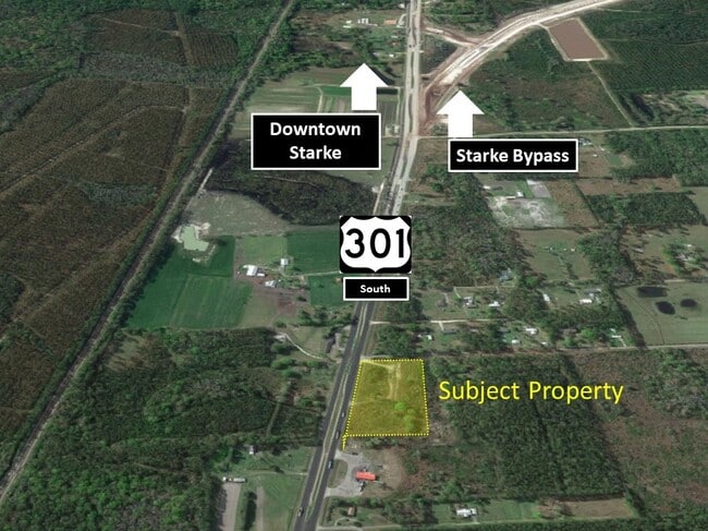
19978 N Us Highway 301 N, Starke, FL 32091

This Property Is For Sale
NEARBY LISTINGS FOR SALE OR LEASE
Property Detail
19978 N Us Highway 301 N
01947-0-00000
3 6S 22 COM NE COR OF SE1/4 OF NW1/4. S01*00E 200, RUN N88*4330W 72.94, S17*2430W 424.82 TO POB. S88*5430E 137.73 TO W R/W TO HWY 301, S17*2430W 769.05, N89*0830W 289.20, N00*4910W 746.63, THENCE S88*5430E 392.50 TO POB. EX: R/W GR RD
Vacantlandnec
Bradford
A
Florida
12019C0125E
7 AC
2025
Florida Central North Area
2025
Other Market Areas
000202
DEMOGRAPHICS near 19978 N Us Highway 301 N
1 Mile
3 Mile
5 Mile
2024 Total Population
295
3,279
13,480
2029 Population
300
3,362
13,957
Pop Growth 2024-2029
+ 1.69%
+ 2.53%
+ 3.54%
Average Age
43
42
42
2024 Total Households
100
1,114
4,820
HH Growth 2024-2029
+ 3.00%
+ 3.14%
+ 3.55%
Median Household Inc
$57,727
$52,924
$46,715
Avg Household Size
2.60
2.60
2.50
2024 Avg HH Vehicles
2.00
2.00
2.00
Median Home Value
$178,947
$164,258
$139,560
Median Year Built
1988
1988
1984
Nearby Places
Map Layers
Map Styles
 Street
 Aerial
- Restaurants
- Banks
- Shops
- Fitness
- Groceries
PUBLIC TRANSPORTATION
AIRPORT
Gainesville Regional
DRIVE
WALK
Distance
Gainesville Regional
39 min
28.5 mi
Freight Ports
Jacksonville Port
DRIVE
WALK
Distance
Jacksonville Port
58 min
44.6 mi
Nearby Properties
Address
Land Use
TOTAL SIZE
Lot Size
Zoning
Address
Land Use
TOTAL SIZE
Lot Size
Zoning
Address
Land Use
TOTAL SIZE
Lot Size
Zoning
33,282 SF
20 AC
Address
Land Use
TOTAL SIZE
Lot Size
Zoning
18,480 SF
10.83 AC
Address
Land Use
TOTAL SIZE
Lot Size
Zoning
370 AC
Address
Land Use
TOTAL SIZE
Lot Size
Zoning
9,576 SF
2.17 AC
Address
Land Use
TOTAL SIZE
Lot Size
Zoning
315.32 AC
Address
Land Use
TOTAL SIZE
Lot Size
Zoning
3,360 SF
15.21 AC
Address
Land Use
TOTAL SIZE
Lot Size
Zoning
3,033 SF
32.66 AC
Address
Land Use
TOTAL SIZE
Lot Size
Zoning
10,545 SF
40 AC
Address
Land Use
TOTAL SIZE
Lot Size
Zoning
13,828 SF
5.95 AC
Address
Land Use
TOTAL SIZE
Lot Size
Zoning
321.95 AC
Address
Land Use
TOTAL SIZE
Lot Size
Zoning
320 AC
Address
Land Use
TOTAL SIZE
Lot Size
Zoning
23,026 SF
1.40 AC
Address
Land Use
TOTAL SIZE
Lot Size
Zoning
16,848 SF
3.20 AC
Address
Land Use
TOTAL SIZE
Lot Size
Zoning
5,613 SF
10 AC
Address
Land Use
TOTAL SIZE
Lot Size
Zoning
228.83 AC
Address
Land Use
TOTAL SIZE
Lot Size
Zoning
6,303 SF
1.84 AC
Address
Land Use
TOTAL SIZE
Lot Size
Zoning
3,600 SF
7.62 AC
Address
Land Use
TOTAL SIZE
Lot Size
Zoning
9,175 SF
1.40 AC
Address
Land Use
TOTAL SIZE
Lot Size
Zoning
4,006 SF
4.46 AC
Address
Land Use
TOTAL SIZE
Lot Size
Zoning
33,954 SF
3.24 AC
Address
Land Use
TOTAL SIZE
Lot Size
Zoning
3,765 SF
5.80 AC
Address
Land Use
TOTAL SIZE
Lot Size
Zoning
11,491 SF
2.40 AC
Address
Land Use
TOTAL SIZE
Lot Size
Zoning
30.70 AC
Address
Land Use
TOTAL SIZE
Lot Size
Zoning
3,858 SF
1.50 AC
Address
Land Use
TOTAL SIZE
Lot Size
Zoning
17,116 SF
7.50 AC
Address
Land Use
TOTAL SIZE
Lot Size
Zoning
5,753 SF
55 AC
Address
Land Use
TOTAL SIZE
Lot Size
Zoning
3,492 SF
25.84 AC
Address
Land Use
TOTAL SIZE
Lot Size
Zoning
37.93 AC
Address
Land Use
TOTAL SIZE
Lot Size
Zoning
9,667 SF
15 AC
The World's #1 Commercial Real Estate Marketplace
Connect with us
© 2025 CoStar Group
The information above has been obtained from sources believed reliable. While we do not doubt its accuracy we have not verified it and make no guarantee, warranty or representation about it. It is your responsibility to independently confirm its accuracy and completeness. Any projections, opinions, assumptions, or estimates used are for example only and do not represent the current or future performance of the property. The value of this transaction to you depends on tax and other factors which should be evaluated by your tax, financial, and legal advisors. You and your advisors should conduct a careful, independent investigation of the property to determine to your satisfaction the suitability of the property for your needs.