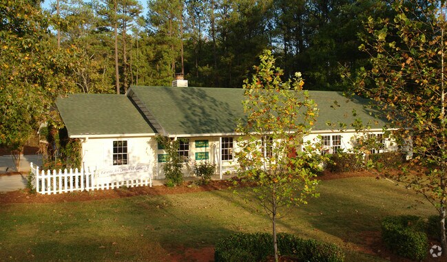
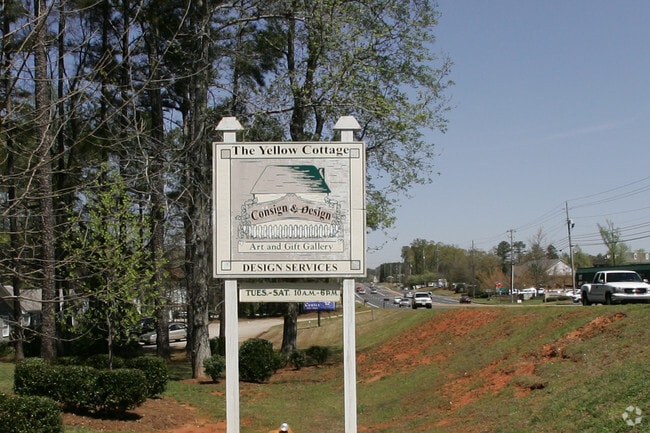
Property Record
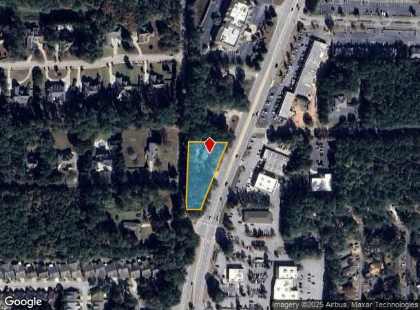
2011 Highway 54 W, Peachtree City, GA 30269

NEARBY LISTINGS FOR SALE OR LEASE
Property Detail
2011 Highway 54 W
07-19-00-032
HWY 54
Storebuilding
Fayette
X
Georgia
13077C0200D
69
2024
0.93 AC
2024
Fayette/Peachtree
140403
Atlanta
2,002 SF
Atlanta-Sandy Springs-Roswell, GA
DEMOGRAPHICS near 2011 Highway 54 W
1 Mile
3 Mile
5 Mile
2024 Total Population
3,411
29,117
64,675
2029 Population
3,596
30,855
68,854
Pop Growth 2024-2029
+ 5.42%
+ 5.97%
+ 6.46%
Average Age
43
43
42
2024 Total Households
1,237
10,882
23,645
HH Growth 2024-2029
+ 5.34%
+ 5.98%
+ 6.49%
Median Household Inc
$97,612
$97,358
$99,155
Avg Household Size
2.70
2.70
2.70
2024 Avg HH Vehicles
2.00
2.00
2.00
Median Home Value
$663,690
$401,493
$380,075
Median Year Built
1993
1991
1993
Nearby Places
Map Layers
Map Styles
 Street
 Aerial
- Restaurants
- Banks
- Shops
- Fitness
- Groceries
PUBLIC TRANSPORTATION
AIRPORT
Hartsfield - Jackson Atlanta International
DRIVE
WALK
Distance
Hartsfield - Jackson Atlanta International
36 min
25.0 mi
Nearby Properties
Address
Land Use
TOTAL SIZE
Lot Size
Zoning
Address
Land Use
TOTAL SIZE
Lot Size
Zoning
353,300 SF
38 AC
Address
Land Use
TOTAL SIZE
Lot Size
Zoning
2,660 SF
C BP
Address
Land Use
TOTAL SIZE
Lot Size
Zoning
245,406 SF
51.77 AC
Address
Land Use
TOTAL SIZE
Lot Size
Zoning
194,839 SF
25.40 AC
C GC
Address
Land Use
TOTAL SIZE
Lot Size
Zoning
118,729 SF
21.25 AC
C GR10
Address
Land Use
TOTAL SIZE
Lot Size
Zoning
163,447 SF
18.70 AC
C LUC
Address
Land Use
TOTAL SIZE
Lot Size
Zoning
218,763 SF
38.40 AC
C GC
Address
Land Use
TOTAL SIZE
Lot Size
Zoning
102,516 SF
19.60 AC
Address
Land Use
TOTAL SIZE
Lot Size
Zoning
75,217 SF
15 AC
CS
Address
Land Use
TOTAL SIZE
Lot Size
Zoning
39,195 SF
14.06 AC
C GC
Address
Land Use
TOTAL SIZE
Lot Size
Zoning
151,533 SF
17.78 AC
C GC
Address
Land Use
TOTAL SIZE
Lot Size
Zoning
202,691 SF
24.65 AC
C GC
Address
Land Use
TOTAL SIZE
Lot Size
Zoning
106,142 SF
13.93 AC
C GR14
Address
Land Use
TOTAL SIZE
Lot Size
Zoning
93,072 SF
28.10 AC
C LUC
Address
Land Use
TOTAL SIZE
Lot Size
Zoning
96,409 SF
12.74 AC
C GC
Address
Land Use
TOTAL SIZE
Lot Size
Zoning
32,126 SF
8.41 AC
C LUC
Address
Land Use
TOTAL SIZE
Lot Size
Zoning
72,703 SF
8 AC
C GC
Address
Land Use
TOTAL SIZE
Lot Size
Zoning
377,939 SF
14.42 AC
I GI
Address
Land Use
TOTAL SIZE
Lot Size
Zoning
55,360 SF
4.80 AC
C LUC
Address
Land Use
TOTAL SIZE
Lot Size
Zoning
230.80 AC
Address
Land Use
TOTAL SIZE
Lot Size
Zoning
48,355 SF
26.70 AC
Address
Land Use
TOTAL SIZE
Lot Size
Zoning
93,925 SF
5.18 AC
C GC
Address
Land Use
TOTAL SIZE
Lot Size
Zoning
35,802 SF
4.39 AC
C OI
Address
Land Use
TOTAL SIZE
Lot Size
Zoning
66,902 SF
8.19 AC
C GC
Address
Land Use
TOTAL SIZE
Lot Size
Zoning
14,166 SF
5.05 AC
C GC
Address
Land Use
TOTAL SIZE
Lot Size
Zoning
75,121 SF
5.21 AC
C GC
Address
Land Use
TOTAL SIZE
Lot Size
Zoning
52,001 SF
4.01 AC
C GC
Address
Land Use
TOTAL SIZE
Lot Size
Zoning
125,421 SF
12.99 AC
C GC
Address
Land Use
TOTAL SIZE
Lot Size
Zoning
44,209 SF
4.71 AC
C LUC
Address
Land Use
TOTAL SIZE
Lot Size
Zoning
47,555 SF
20.10 AC
AR
The World's #1 Commercial Real Estate Marketplace
Connect with us
© 2025 CoStar Group
The information above has been obtained from sources believed reliable. While we do not doubt its accuracy we have not verified it and make no guarantee, warranty or representation about it. It is your responsibility to independently confirm its accuracy and completeness. Any projections, opinions, assumptions, or estimates used are for example only and do not represent the current or future performance of the property. The value of this transaction to you depends on tax and other factors which should be evaluated by your tax, financial, and legal advisors. You and your advisors should conduct a careful, independent investigation of the property to determine to your satisfaction the suitability of the property for your needs.