Property Record
1999 N 8Th St, Banning, CA 92220


Property Detail
1999 N 8Th St
535-080-018
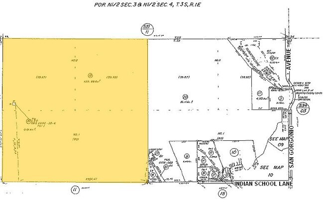
159.88 ACRES M/L IN POR NW 1/4 OF SEC 4 T3S R1E FOR TOTAL DESCRIPTION SEE ASSESSORS MAPS
Storebuilding
RIVERSIDE
RR
California
B and X Area of moderate flood hazard, usually the area between the limits of the 100-year and 500-year floods.
159.88 AC
2024
Beaumont/Hemet
2025
Inland Empire (California)
044104
Riverside-San Bernardino-Ontario, CA
1,870 SF
NEARBY LISTINGS FOR SALE OR LEASE
-
-
-
-
-
-
No Photo
-
-
View all Banning listings for sale on LoopNet.com
DEMOGRAPHICS near 1999 N 8Th St
1 mile
3 mile
5 mile
2025 Total Population
7,084
29,278
70,169
2030 Population
7,251
30,438
72,562
Pop Growth 2025-2030
+ 2.36%
+ 3.96%
+ 3.41%
Average Age
37
40
41
2025 Total Households
2,195
9,398
23,908
HH Growth 2025-2030
+ 2.05%
+ 3.49%
+ 2.94%
Median Household Inc
$71,532
$62,061
$75,568
Avg Household Size
3.20
2.90
2.80
2025 Avg HH Vehicles
2.00
2.00
2.00
Median Home Value
$356,234
$343,841
$439,255
Median Year Built
1965
1979
1993
Nearby Places
Map Layers
Map Styles
 Street
 Aerial
Layers
 Traffic
 Biking
Places
Listings with unknown addresses are not visible on the map
- Restaurants
- Banks
- Shops
- Fitness
- Groceries
PUBLIC TRANSPORTATION
AIRPORT
Palm Springs International
Drive
Walk
Distance
Palm Springs International
48 min
30.9 mi
Freight Ports
Port of Long Beach
Drive
Walk
Distance
Port of Long Beach
122 min
88.1 mi
SALE & LEASE HISTORY
LISTING DATE
SALE/LEASE

May 06, 2022
For Sale
Jan 05, 2022
For Sale
Nearby Properties
Address
Land Use
TOTAL SIZE
Lot Size
Zoning
Address
Land Use
TOTAL SIZE
Lot Size
Zoning
116,175 SF
4.86 AC
RA
Address
Land Use
TOTAL SIZE
Lot Size
Zoning
83,989 SF
39.10 AC
M1
Address
Land Use
TOTAL SIZE
Lot Size
Zoning
54,131 SF
3.23 AC
M1
Address
Land Use
TOTAL SIZE
Lot Size
Zoning
82,587 SF
6.78 AC
Address
Land Use
TOTAL SIZE
Lot Size
Zoning
39,250 SF
1.38 AC
C2
Address
Land Use
TOTAL SIZE
Lot Size
Zoning
909 SF
8.17 AC
RA
Address
Land Use
TOTAL SIZE
Lot Size
Zoning
20,800 SF
1.10 AC
C2
Address
Land Use
TOTAL SIZE
Lot Size
Zoning
54,455 SF
5.53 AC
R3
Address
Land Use
TOTAL SIZE
Lot Size
Zoning
44,335 SF
4 AC
Address
Land Use
TOTAL SIZE
Lot Size
Zoning
17,272 SF
1.99 AC
Address
Land Use
TOTAL SIZE
Lot Size
Zoning
119,662 SF
6.65 AC
Address
Land Use
TOTAL SIZE
Lot Size
Zoning
119,400 SF
8.21 AC
M
Address
Land Use
TOTAL SIZE
Lot Size
Zoning
50,000 SF
7.13 AC
CM
Address
Land Use
TOTAL SIZE
Lot Size
Zoning
27,660 SF
1.13 AC
R3
Address
Land Use
TOTAL SIZE
Lot Size
Zoning
26,916 SF
1.23 AC
R3
Address
Land Use
TOTAL SIZE
Lot Size
Zoning
32,520 SF
2.01 AC
Address
Land Use
TOTAL SIZE
Lot Size
Zoning
28,165 SF
2.41 AC
Address
Land Use
TOTAL SIZE
Lot Size
Zoning
102,760 SF
13.29 AC
Address
Land Use
TOTAL SIZE
Lot Size
Zoning
864 SF
4.30 AC
M
Address
Land Use
TOTAL SIZE
Lot Size
Zoning
30,000 SF
2.21 AC
C2
Address
Land Use
TOTAL SIZE
Lot Size
Zoning
29,928 SF
2.98 AC
Address
Land Use
TOTAL SIZE
Lot Size
Zoning
20,304 SF
0.91 AC
RA
Address
Land Use
TOTAL SIZE
Lot Size
Zoning
93,469 SF
7.46 AC
Address
Land Use
TOTAL SIZE
Lot Size
Zoning
15,000 SF
0.99 AC
Address
Land Use
TOTAL SIZE
Lot Size
Zoning
15.29 AC
W2
Address
Land Use
TOTAL SIZE
Lot Size
Zoning
15.25 AC
W2
The World's #1 Commercial Real Estate Marketplace
Connect with us
© 2026 CoStar Group
The information above has been obtained from sources believed reliable. While we do not doubt its accuracy we have not verified it and make no guarantee, warranty or representation about it. It is your responsibility to independently confirm its accuracy and completeness. Any projections, opinions, assumptions, or estimates used are for example only and do not represent the current or future performance of the property. The value of this transaction to you depends on tax and other factors which should be evaluated by your tax, financial, and legal advisors. You and your advisors should conduct a careful, independent investigation of the property to determine to your satisfaction the suitability of the property for your needs.