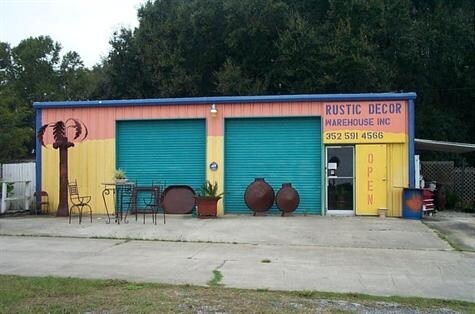
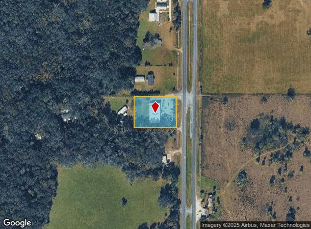
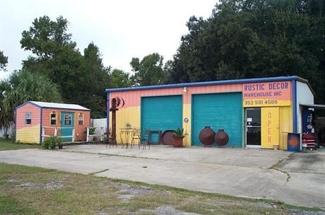
Property Record
19998 Highway 441 N, Micanopy, FL 32667
NEARBY LISTINGS FOR SALE OR LEASE
Property Detail
19998 Highway 441 N
02692-000-00
SEC 20 TWP 12 RGE 21 BEG AT NE COR OF SEC 20 TH S 230 FT TH W 405.98 FT TH N 230 FT TH E 405.98 FT TO POB. LESS & EXCEPT ANY PART THEREOF LYING WITHIN ROW OF US HWY 441 & EXCEPT S 25 FT THEREOF
Storemultistory
Marion
X
Florida
12083C0130D
1.24 AC
2025
Outlying Marion County
2025
Ocala
000203
Ocala, FL
9,370 SF
DEMOGRAPHICS near 19998 Highway 441 N
1 Mile
3 Mile
5 Mile
2024 Total Population
225
1,748
4,676
2029 Population
242
1,887
5,144
Pop Growth 2024-2029
+ 7.56%
+ 7.95%
+ 10.01%
Average Age
47
47
46
2024 Total Households
99
765
2,001
HH Growth 2024-2029
+ 7.07%
+ 7.71%
+ 9.75%
Median Household Inc
$46,666
$47,857
$55,323
Avg Household Size
2.30
2.30
2.30
2024 Avg HH Vehicles
2.00
2.00
2.00
Median Home Value
$250,000
$252,105
$275,617
Median Year Built
1980
1980
1983
Nearby Places
Map Layers
Map Styles
 Street
 Aerial
- Restaurants
- Banks
- Shops
- Fitness
- Groceries
PUBLIC TRANSPORTATION
AIRPORT
Gainesville Regional
DRIVE
WALK
Distance
Gainesville Regional
37 min
22.9 mi
Nearby Properties
Address
Land Use
TOTAL SIZE
Lot Size
Zoning
Address
Land Use
TOTAL SIZE
Lot Size
Zoning
32,861 SF
115.49 AC
PRV
Address
Land Use
TOTAL SIZE
Lot Size
Zoning
6,144 SF
140.91 AC
PUD
Address
Land Use
TOTAL SIZE
Lot Size
Zoning
38,715 SF
50 AC
B3
Address
Land Use
TOTAL SIZE
Lot Size
Zoning
2,616 SF
41.47 AC
PUD
Address
Land Use
TOTAL SIZE
Lot Size
Zoning
11,063 SF
417.23 AC
A1
Address
Land Use
TOTAL SIZE
Lot Size
Zoning
62,288 SF
49.98 AC
B4
Address
Land Use
TOTAL SIZE
Lot Size
Zoning
12,319 SF
50.98 AC
A1
Address
Land Use
TOTAL SIZE
Lot Size
Zoning
15,397 SF
7.24 AC
B2
Address
Land Use
TOTAL SIZE
Lot Size
Zoning
21,120 SF
3.14 AC
B5
Address
Land Use
TOTAL SIZE
Lot Size
Zoning
10,580 SF
1.86 AC
B4
Address
Land Use
TOTAL SIZE
Lot Size
Zoning
9,603 SF
6.30 AC
GU
Address
Land Use
TOTAL SIZE
Lot Size
Zoning
11,280 SF
9.01 AC
B2
Address
Land Use
TOTAL SIZE
Lot Size
Zoning
21,287 SF
10.01 AC
B2
Address
Land Use
TOTAL SIZE
Lot Size
Zoning
83.57 AC
A1
Address
Land Use
TOTAL SIZE
Lot Size
Zoning
6,468 SF
159.54 AC
A1
Address
Land Use
TOTAL SIZE
Lot Size
Zoning
9,230 SF
1.24 AC
B4
Address
Land Use
TOTAL SIZE
Lot Size
Zoning
21,655 SF
33.01 AC
A1
Address
Land Use
TOTAL SIZE
Lot Size
Zoning
5,091 SF
19.70 AC
A1
Address
Land Use
TOTAL SIZE
Lot Size
Zoning
5 AC
B2
Address
Land Use
TOTAL SIZE
Lot Size
Zoning
2,805 SF
52.99 AC
B2
Address
Land Use
TOTAL SIZE
Lot Size
Zoning
5,318 SF
7.09 AC
A1
Address
Land Use
TOTAL SIZE
Lot Size
Zoning
9,927 SF
3.42 AC
B4
Address
Land Use
TOTAL SIZE
Lot Size
Zoning
1,108 SF
29.96 AC
B2
Address
Land Use
TOTAL SIZE
Lot Size
Zoning
16,475 SF
8 AC
M1
Address
Land Use
TOTAL SIZE
Lot Size
Zoning
4,420 SF
1.68 AC
B2
Address
Land Use
TOTAL SIZE
Lot Size
Zoning
4,668 SF
2.27 AC
B4
Address
Land Use
TOTAL SIZE
Lot Size
Zoning
3,528 SF
1.18 AC
B2
Address
Land Use
TOTAL SIZE
Lot Size
Zoning
4,325 SF
29.50 AC
A1
Address
Land Use
TOTAL SIZE
Lot Size
Zoning
4,800 SF
0.66 AC
B2
Address
Land Use
TOTAL SIZE
Lot Size
Zoning
6,349 SF
0.90 AC
GU
The World's #1 Commercial Real Estate Marketplace
Connect with us
© 2026 CoStar Group
The information above has been obtained from sources believed reliable. While we do not doubt its accuracy we have not verified it and make no guarantee, warranty or representation about it. It is your responsibility to independently confirm its accuracy and completeness. Any projections, opinions, assumptions, or estimates used are for example only and do not represent the current or future performance of the property. The value of this transaction to you depends on tax and other factors which should be evaluated by your tax, financial, and legal advisors. You and your advisors should conduct a careful, independent investigation of the property to determine to your satisfaction the suitability of the property for your needs.