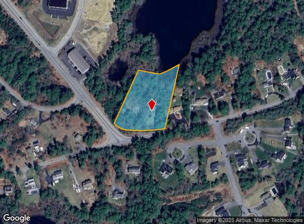
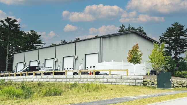
Property Record
158 High St, Carver, MA 02330

NEARBY LISTINGS FOR SALE OR LEASE
-
-
View all Carver listings for sale on LoopNet.com
Property Detail
158 High St
Boston-Cambridge-Newton, MA-NH
Plymouth
CARV-000032-000000-000004-A000002
Massachusetts
Sfr
1.98 AC
X
Route 3 South
25023C0334K
Boston
1,250 SF
DEMOGRAPHICS near 158 High St
1 Mile
3 Mile
5 Mile
2024 Total Population
884
14,261
46,421
2029 Population
902
14,350
46,749
Pop Growth 2024-2029
+ 2.04%
+ 0.62%
+ 0.71%
Average Age
40
43
43
2024 Total Households
297
5,223
17,899
HH Growth 2024-2029
+ 2.02%
+ 0.52%
+ 0.61%
Median Household Inc
$113,281
$105,631
$95,853
Avg Household Size
2.80
2.70
2.50
2024 Avg HH Vehicles
2.00
2.00
2.00
Median Home Value
$466,091
$435,527
$435,358
Median Year Built
1981
1979
1977
Nearby Places
Map Layers
Map Styles
 Street
 Aerial
- Restaurants
- Banks
- Shops
- Fitness
- Groceries
PUBLIC TRANSPORTATION
COMMUTER RAIL
Kingston/Route 3 (Kingston/Plymouth Line - Massachusetts Bay Transportation Authority Commuter Rail (Purple Line))
DRIVE
WALK
Distance
Kingston/Route 3 (Kingston/Plymouth Line - Massachusetts Bay Transportation Authority Commuter Rail (Purple Line))
13 min
6.3 mi
Halifax (Kingston/Plymouth Line - Massachusetts Bay Transportation Authority Commuter Rail (Purple Line))
DRIVE
WALK
Distance
Halifax (Kingston/Plymouth Line - Massachusetts Bay Transportation Authority Commuter Rail (Purple Line))
18 min
8.8 mi
Freight Ports
Port of New Bedford Harbor
DRIVE
WALK
Distance
Port of New Bedford Harbor
46 min
32.1 mi
SALE & LEASE HISTORY
LISTING DATE
SALE/LEASE

Sep 09, 2024
For Sale
Apr 27, 2022
For Lease
Nearby Properties
Address
Land Use
TOTAL SIZE
Lot Size
Zoning
Address
Land Use
TOTAL SIZE
Lot Size
Zoning
14.60 AC
MC
Address
Land Use
TOTAL SIZE
Lot Size
Zoning
82.62 AC
I
Address
Land Use
TOTAL SIZE
Lot Size
Zoning
26.16 AC
MC
Address
Land Use
TOTAL SIZE
Lot Size
Zoning
27.31 AC
MC
Address
Land Use
TOTAL SIZE
Lot Size
Zoning
69.81 AC
Address
Land Use
TOTAL SIZE
Lot Size
Zoning
214,442 SF
21.50 AC
MC
Address
Land Use
TOTAL SIZE
Lot Size
Zoning
122,558 SF
17.44 AC
GC
Address
Land Use
TOTAL SIZE
Lot Size
Zoning
15.13 AC
HC
Address
Land Use
TOTAL SIZE
Lot Size
Zoning
9.41 AC
MC
Address
Land Use
TOTAL SIZE
Lot Size
Zoning
16.30 AC
GC
Address
Land Use
TOTAL SIZE
Lot Size
Zoning
68,240 SF
10 AC
R1
Address
Land Use
TOTAL SIZE
Lot Size
Zoning
0.24 AC
R25
Address
Land Use
TOTAL SIZE
Lot Size
Zoning
110,760 SF
2.09 AC
MC
Address
Land Use
TOTAL SIZE
Lot Size
Zoning
30,105 SF
6.45 AC
MC
Address
Land Use
TOTAL SIZE
Lot Size
Zoning
59,377 SF
2.95 AC
MC
Address
Land Use
TOTAL SIZE
Lot Size
Zoning
58,356 SF
32.04 AC
R25
Address
Land Use
TOTAL SIZE
Lot Size
Zoning
52,447 SF
19.89 AC
Address
Land Use
TOTAL SIZE
Lot Size
Zoning
5.43 AC
R25
Address
Land Use
TOTAL SIZE
Lot Size
Zoning
3.55 AC
MC
Address
Land Use
TOTAL SIZE
Lot Size
Zoning
6.81 AC
GC
Address
Land Use
TOTAL SIZE
Lot Size
Zoning
45.45 AC
I
Address
Land Use
TOTAL SIZE
Lot Size
Zoning
24,580 SF
2.07 AC
LI
Address
Land Use
TOTAL SIZE
Lot Size
Zoning
21,791 SF
5.05 AC
MC
Address
Land Use
TOTAL SIZE
Lot Size
Zoning
72,404 SF
3.10 AC
MC
Address
Land Use
TOTAL SIZE
Lot Size
Zoning
16,744 SF
24.62 AC
Address
Land Use
TOTAL SIZE
Lot Size
Zoning
5.64 AC
MC
Address
Land Use
TOTAL SIZE
Lot Size
Zoning
5.19 AC
MC
Address
Land Use
TOTAL SIZE
Lot Size
Zoning
147.50 AC
Address
Land Use
TOTAL SIZE
Lot Size
Zoning
26,950 SF
1.96 AC
LI
Address
Land Use
TOTAL SIZE
Lot Size
Zoning
2.01 AC
LI
The World's #1 Commercial Real Estate Marketplace
Connect with us
© 2026 CoStar Group
The information above has been obtained from sources believed reliable. While we do not doubt its accuracy we have not verified it and make no guarantee, warranty or representation about it. It is your responsibility to independently confirm its accuracy and completeness. Any projections, opinions, assumptions, or estimates used are for example only and do not represent the current or future performance of the property. The value of this transaction to you depends on tax and other factors which should be evaluated by your tax, financial, and legal advisors. You and your advisors should conduct a careful, independent investigation of the property to determine to your satisfaction the suitability of the property for your needs.