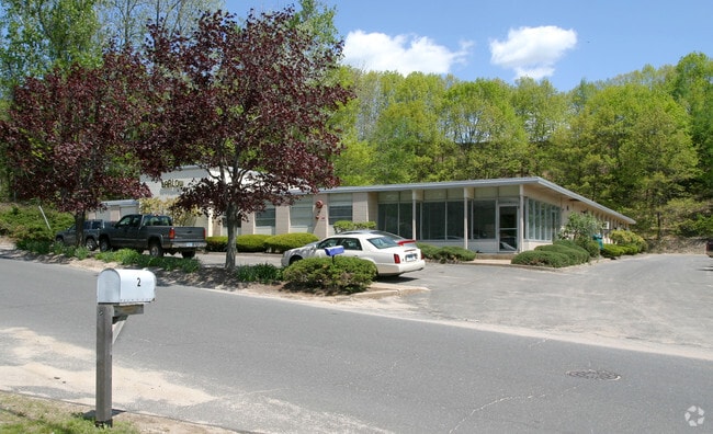
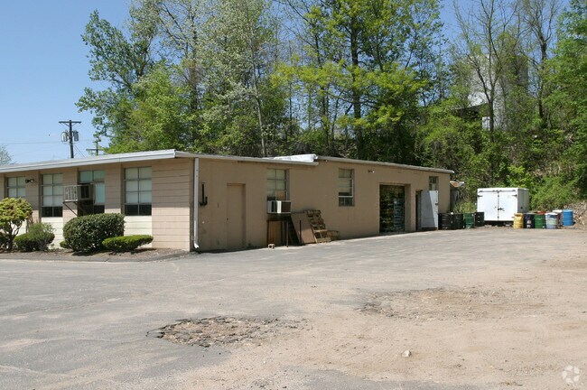
Property Record
2 Barlow St, Bristol, CT 06010

Property Detail
2 Barlow St
BRIS-000067-000000-000013-000008
Naugatuck Vly
Commercialnec
Connecticut
BN
13-8
C and X Area of minimal flood hazard, usually depicted on FIRMs as above the 500-year flood level.
2 AC
2025
Bristol
2025
Hartford
405700
Hartford-West Hartford-East Hartford, CT
6,560 SF
NEARBY LISTINGS FOR SALE OR LEASE
DEMOGRAPHICS near 2 Barlow St
1 mile
3 mile
5 mile
2025 Total Population
4,072
45,001
90,777
2030 Population
4,207
46,283
93,230
Pop Growth 2025-2030
+ 3.32%
+ 2.85%
+ 2.70%
Average Age
41
41
42
2025 Total Households
1,745
18,579
37,643
HH Growth 2025-2030
+ 3.27%
+ 2.85%
+ 2.70%
Median Household Inc
$100,083
$81,450
$87,514
Avg Household Size
2.30
2.40
2.30
2025 Avg HH Vehicles
2.00
2.00
2.00
Median Home Value
$268,977
$277,474
$286,190
Median Year Built
1975
1965
1968
Nearby Places
Map Layers
Map Styles
 Street
 Aerial
Transit
 Traffic
 Biking
Places
Listings with unknown addresses are not visible on the map
- Restaurants
- Banks
- Shops
- Fitness
- Groceries
PUBLIC TRANSPORTATION
AIRPORT
Bradley International
Drive
Walk
Distance
Bradley International
58 min
33.0 mi
Tweed/New Haven
Drive
Walk
Distance
Tweed/New Haven
51 min
34.3 mi
Nearby Properties
Address
Land Use
TOTAL SIZE
Lot Size
Zoning
Address
Land Use
TOTAL SIZE
Lot Size
Zoning
349,054 SF
12.03 AC
R-15
Address
Land Use
TOTAL SIZE
Lot Size
Zoning
139 AC
IP-25
Address
Land Use
TOTAL SIZE
Lot Size
Zoning
121,917 SF
28.60 AC
R-15
Address
Land Use
TOTAL SIZE
Lot Size
Zoning
12,892 SF
20.91 AC
A
Address
Land Use
TOTAL SIZE
Lot Size
Zoning
56,184 SF
19.42 AC
BG
Address
Land Use
TOTAL SIZE
Lot Size
Zoning
171,826 SF
36.60 AC
R-15
Address
Land Use
TOTAL SIZE
Lot Size
Zoning
199,744 SF
44.70 AC
R-15
Address
Land Use
TOTAL SIZE
Lot Size
Zoning
62,232 SF
0.90 AC
BD-1
Address
Land Use
TOTAL SIZE
Lot Size
Zoning
169,727 SF
23.90 AC
R-25
Address
Land Use
TOTAL SIZE
Lot Size
Zoning
4,000 SF
13.78 AC
BG
Address
Land Use
TOTAL SIZE
Lot Size
Zoning
1,700 SF
38.81 AC
A
Address
Land Use
TOTAL SIZE
Lot Size
Zoning
120,801 SF
8.35 AC
R-40
Address
Land Use
TOTAL SIZE
Lot Size
Zoning
51,851 SF
1.32 AC
BD-1
Address
Land Use
TOTAL SIZE
Lot Size
Zoning
1,250 SF
14.90 AC
I
Address
Land Use
TOTAL SIZE
Lot Size
Zoning
47,218 SF
3.62 AC
BD-1
Address
Land Use
TOTAL SIZE
Lot Size
Zoning
3.35 AC
RA2
Address
Land Use
TOTAL SIZE
Lot Size
Zoning
80,776 SF
2.49 AC
BD-1
Address
Land Use
TOTAL SIZE
Lot Size
Zoning
60,935 SF
0.92 AC
BD-1
Address
Land Use
TOTAL SIZE
Lot Size
Zoning
134,955 SF
3.30 AC
BD-2
Address
Land Use
TOTAL SIZE
Lot Size
Zoning
63,101 SF
15.50 AC
R-25
Address
Land Use
TOTAL SIZE
Lot Size
Zoning
45,377 SF
91.90 AC
R-40
Address
Land Use
TOTAL SIZE
Lot Size
Zoning
97,356 SF
3.40 AC
I
Address
Land Use
TOTAL SIZE
Lot Size
Zoning
68,520 SF
2 AC
BD-1
Address
Land Use
TOTAL SIZE
Lot Size
Zoning
47,271 SF
1.32 AC
R-15/B
Address
Land Use
TOTAL SIZE
Lot Size
Zoning
9,430 SF
3.91 AC
R-15
Address
Land Use
TOTAL SIZE
Lot Size
Zoning
28,480 SF
5.50 AC
A
Address
Land Use
TOTAL SIZE
Lot Size
Zoning
81,741 SF
2.76 AC
R-15/R
Address
Land Use
TOTAL SIZE
Lot Size
Zoning
49,977 SF
15.56 AC
R-25
Address
Land Use
TOTAL SIZE
Lot Size
Zoning
11,735 SF
2.33 AC
BG
Address
Land Use
TOTAL SIZE
Lot Size
Zoning
38,542 SF
1.96 AC
BD-1
The World's #1 Commercial Real Estate Marketplace
Connect with us
© 2026 CoStar Group
The information above has been obtained from sources believed reliable. While we do not doubt its accuracy we have not verified it and make no guarantee, warranty or representation about it. It is your responsibility to independently confirm its accuracy and completeness. Any projections, opinions, assumptions, or estimates used are for example only and do not represent the current or future performance of the property. The value of this transaction to you depends on tax and other factors which should be evaluated by your tax, financial, and legal advisors. You and your advisors should conduct a careful, independent investigation of the property to determine to your satisfaction the suitability of the property for your needs.