Property Record
2 Barthold Ave, Patchogue, NY 11772

Save to a Folder
{{folder.Name}}
{{folder.ListingIds.length}} Properties
{{folder.ListingIds.length}} Property
Create a New Folder
Property Detail
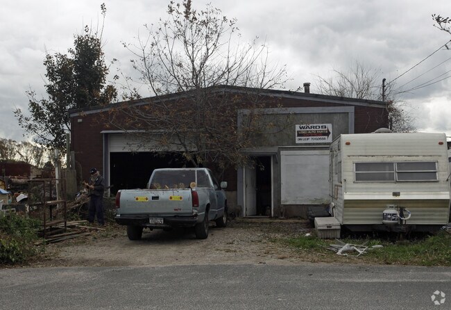
2 Barthold Ave
Nassau County-Suffolk County, NY
N BARTHOLDI AVE E NUZZI T5026 S NUZ
0200-977-90-04-00-022-000
SUFFOLK
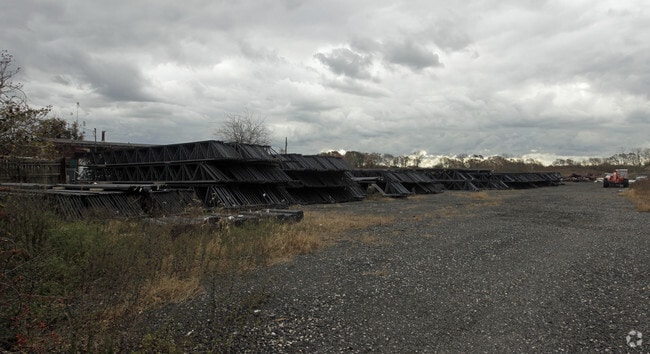
Storageyardjunkautowreckingsalvage
New York
B and X Area of moderate flood hazard, usually the area between the limits of the 100-year and 500-year floods.
400
2024
0.46 AC
2025
Central Suffolk
159109
Long Island (New York)
NEARBY LISTINGS FOR SALE OR LEASE
-
-
View all Patchogue listings for sale on LoopNet.com
DEMOGRAPHICS near 2 Barthold Ave
1 mile
3 mile
5 mile
2025 Total Population
7,643
50,738
105,666
2030 Population
7,678
50,668
105,407
Pop Growth 2025-2030
+ 0.46%
(0.14%)
(0.25%)
Average Age
41
41
42
2025 Total Households
2,476
17,814
36,972
HH Growth 2025-2030
+ 0.12%
(0.48%)
(0.55%)
Median Household Inc
$123,528
$106,957
$113,481
Avg Household Size
2.80
2.70
2.70
2025 Avg HH Vehicles
2.00
2.00
2.00
Median Home Value
$496,134
$482,907
$493,830
Median Year Built
1972
1973
1973
Nearby Places
Map Layers
Map Styles
 Street
 Aerial
Layers
 Traffic
 Biking
Places
Listings with unknown addresses are not visible on the map
- Restaurants
- Banks
- Shops
- Fitness
- Groceries
PUBLIC TRANSPORTATION
COMMUTER RAIL
Bellport Station (Montauk Branch - Long Island Rail Road)
Drive
Walk
Distance
Bellport Station (Montauk Branch - Long Island Rail Road)
4 min
1.6 mi
Patchogue Station (Montauk Branch - Long Island Rail Road)
Drive
Walk
Distance
Patchogue Station (Montauk Branch - Long Island Rail Road)
7 min
3.4 mi
AIRPORT
Long Island MacArthur
Drive
Walk
Distance
Long Island MacArthur
19 min
9.6 mi
Nearby Properties
Address
Land Use
TOTAL SIZE
Lot Size
Zoning
Address
Land Use
TOTAL SIZE
Lot Size
Zoning
28,932 SF
2.74 AC
R80
Address
Land Use
TOTAL SIZE
Lot Size
Zoning
2.06 AC
R40
Address
Land Use
TOTAL SIZE
Lot Size
Zoning
3,942 SF
0.45 AC
VILLA
Address
Land Use
TOTAL SIZE
Lot Size
Zoning
3,960 SF
0.72 AC
R40
Address
Land Use
TOTAL SIZE
Lot Size
Zoning
2,946 SF
1.04 AC
R20
Address
Land Use
TOTAL SIZE
Lot Size
Zoning
28.97 AC
Address
Land Use
TOTAL SIZE
Lot Size
Zoning
1 AC
R40
Address
Land Use
TOTAL SIZE
Lot Size
Zoning
32.04 AC
Address
Land Use
TOTAL SIZE
Lot Size
Zoning
2,880 SF
0.40 AC
VB
Address
Land Use
TOTAL SIZE
Lot Size
Zoning
8.30 AC
Address
Land Use
TOTAL SIZE
Lot Size
Zoning
0.80 AC
CR80
Address
Land Use
TOTAL SIZE
Lot Size
Zoning
19.01 AC
Address
Land Use
TOTAL SIZE
Lot Size
Zoning
0.98 AC
CR80
Address
Land Use
TOTAL SIZE
Lot Size
Zoning
2,444 SF
0.17 AC
VILLA
Address
Land Use
TOTAL SIZE
Lot Size
Zoning
32.52 AC
Address
Land Use
TOTAL SIZE
Lot Size
Zoning
0.02 AC
R40
Address
Land Use
TOTAL SIZE
Lot Size
Zoning
1,828 SF
0.18 AC
VILLA
Address
Land Use
TOTAL SIZE
Lot Size
Zoning
5.62 AC
Address
Land Use
TOTAL SIZE
Lot Size
Zoning
0.99 AC
Address
Land Use
TOTAL SIZE
Lot Size
Zoning
21.19 AC
Address
Land Use
TOTAL SIZE
Lot Size
Zoning
9.25 AC
Address
Land Use
TOTAL SIZE
Lot Size
Zoning
37.29 AC
Address
Land Use
TOTAL SIZE
Lot Size
Zoning
65.86 AC
Address
Land Use
TOTAL SIZE
Lot Size
Zoning
14.02 AC
Address
Land Use
TOTAL SIZE
Lot Size
Zoning
Address
Land Use
TOTAL SIZE
Lot Size
Zoning
23.66 AC
Address
Land Use
TOTAL SIZE
Lot Size
Zoning
49.68 AC
Address
Land Use
TOTAL SIZE
Lot Size
Zoning
6.33 AC
I1
Address
Land Use
TOTAL SIZE
Lot Size
Zoning
Address
Land Use
TOTAL SIZE
Lot Size
Zoning
1.36 AC
The World's #1 Commercial Real Estate Marketplace
Connect with us
© 2026 CoStar Group
The information above has been obtained from sources believed reliable. While we do not doubt its accuracy we have not verified it and make no guarantee, warranty or representation about it. It is your responsibility to independently confirm its accuracy and completeness. Any projections, opinions, assumptions, or estimates used are for example only and do not represent the current or future performance of the property. The value of this transaction to you depends on tax and other factors which should be evaluated by your tax, financial, and legal advisors. You and your advisors should conduct a careful, independent investigation of the property to determine to your satisfaction the suitability of the property for your needs.