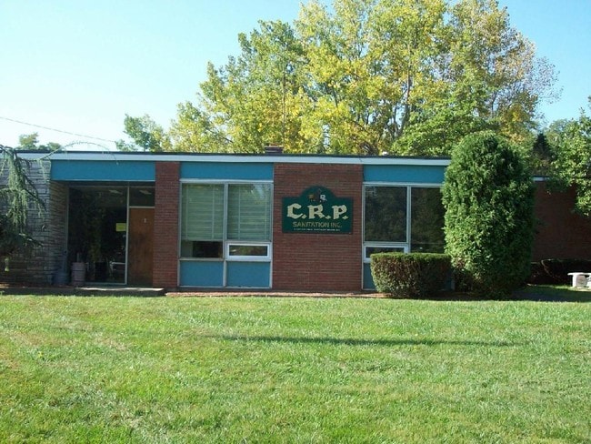
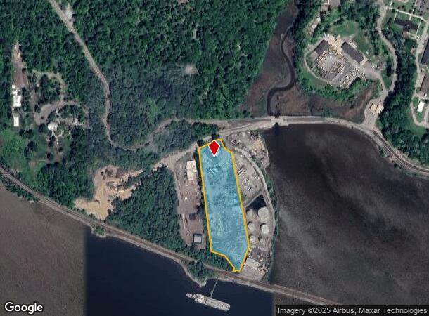
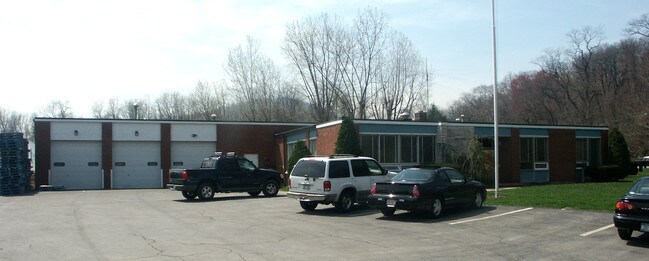
Property Record
2 Bay View Rd, Cortlandt Manor, NY 10567

NEARBY LISTINGS FOR SALE OR LEASE
Property Detail
2 Bay View Rd
2289-022-019-00001-000-0001
Westchester
Utilities
New York
AE
1.000
36087C0037G
6.56 AC
2025
Northwest
2024
Westchester/So Connecticut
014701
New York-Jersey City-White Plains, NY-NJ
DEMOGRAPHICS near 2 Bay View Rd
1 Mile
3 Mile
5 Mile
2024 Total Population
52
32,215
69,375
2029 Population
52
31,352
67,732
Pop Growth 2024-2029
0.00%
(2.68%)
(2.37%)
Average Age
40
41
42
2024 Total Households
17
12,038
25,212
HH Growth 2024-2029
0.00%
(2.84%)
(2.55%)
Median Household Inc
$141,666
$86,931
$104,036
Avg Household Size
2.90
2.50
2.60
2024 Avg HH Vehicles
2.00
2.00
2.00
Median Home Value
$483,333
$358,457
$399,224
Median Year Built
1967
1961
1961
Nearby Places
- Restaurants
- Banks
- Shops
- Fitness
- Groceries
PUBLIC TRANSPORTATION
COMMUTER RAIL
Manitou Station (Hudson Line - Metro-North Commuter Railroad Company (Metro-North))
DRIVE
WALK
Distance
Manitou Station (Hudson Line - Metro-North Commuter Railroad Company (Metro-North))
11 min
5.1 mi
Garrison Station (Hudson Line - Metro-North Commuter Railroad Company (Metro-North))
DRIVE
WALK
Distance
Garrison Station (Hudson Line - Metro-North Commuter Railroad Company (Metro-North))
16 min
8.1 mi
AIRPORT
New York Stewart International
DRIVE
WALK
Distance
New York Stewart International
39 min
22.6 mi
Westchester County
DRIVE
WALK
Distance
Westchester County
58 min
42.6 mi
Freight Ports
Maher Terminal
DRIVE
WALK
Distance
Maher Terminal
81 min
59.8 mi
Nearby Properties
Address
Land Use
TOTAL SIZE
Lot Size
Zoning
Address
Land Use
TOTAL SIZE
Lot Size
Zoning
Address
Land Use
TOTAL SIZE
Lot Size
Zoning
Address
Land Use
TOTAL SIZE
Lot Size
Zoning
157 AC
Address
Land Use
TOTAL SIZE
Lot Size
Zoning
74.84 AC
Address
Land Use
TOTAL SIZE
Lot Size
Zoning
Address
Land Use
TOTAL SIZE
Lot Size
Zoning
1.90 AC
R-1-R
Address
Land Use
TOTAL SIZE
Lot Size
Zoning
Address
Land Use
TOTAL SIZE
Lot Size
Zoning
47.50 AC
Address
Land Use
TOTAL SIZE
Lot Size
Zoning
Address
Land Use
TOTAL SIZE
Lot Size
Zoning
Address
Land Use
TOTAL SIZE
Lot Size
Zoning
35.10 AC
Address
Land Use
TOTAL SIZE
Lot Size
Zoning
7,978 SF
2 AC
R-1-R
Address
Land Use
TOTAL SIZE
Lot Size
Zoning
2.70 AC
Address
Land Use
TOTAL SIZE
Lot Size
Zoning
18.27 AC
R80
Address
Land Use
TOTAL SIZE
Lot Size
Zoning
Address
Land Use
TOTAL SIZE
Lot Size
Zoning
7,254 SF
17.72 AC
R80
Address
Land Use
TOTAL SIZE
Lot Size
Zoning
9,707 SF
5.51 AC
R80
Address
Land Use
TOTAL SIZE
Lot Size
Zoning
22.61 AC
Address
Land Use
TOTAL SIZE
Lot Size
Zoning
8.93 AC
Address
Land Use
TOTAL SIZE
Lot Size
Zoning
11,482 SF
6.50 AC
R-1-R
Address
Land Use
TOTAL SIZE
Lot Size
Zoning
2.99 AC
Address
Land Use
TOTAL SIZE
Lot Size
Zoning
15.02 AC
Address
Land Use
TOTAL SIZE
Lot Size
Zoning
5,860 SF
5.50 AC
R-1-R
Address
Land Use
TOTAL SIZE
Lot Size
Zoning
4,160 SF
3.75 AC
R80
Address
Land Use
TOTAL SIZE
Lot Size
Zoning
Address
Land Use
TOTAL SIZE
Lot Size
Zoning
Address
Land Use
TOTAL SIZE
Lot Size
Zoning
7.50 AC
Address
Land Use
TOTAL SIZE
Lot Size
Zoning
148.54 AC
R80
Address
Land Use
TOTAL SIZE
Lot Size
Zoning
9,604 SF
17.25 AC
B2
The World's #1 Commercial Real Estate Marketplace
Connect with us
© 2025 CoStar Group
The information above has been obtained from sources believed reliable. While we do not doubt its accuracy we have not verified it and make no guarantee, warranty or representation about it. It is your responsibility to independently confirm its accuracy and completeness. Any projections, opinions, assumptions, or estimates used are for example only and do not represent the current or future performance of the property. The value of this transaction to you depends on tax and other factors which should be evaluated by your tax, financial, and legal advisors. You and your advisors should conduct a careful, independent investigation of the property to determine to your satisfaction the suitability of the property for your needs.