Property Record
2 Brook St, Haskell, NJ 07420
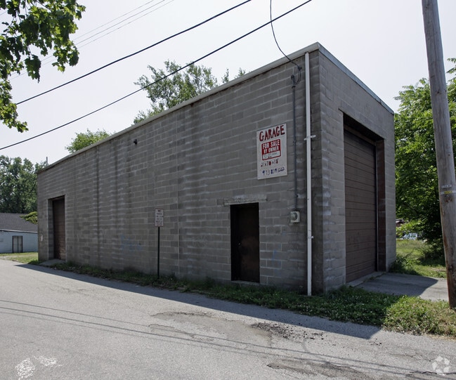

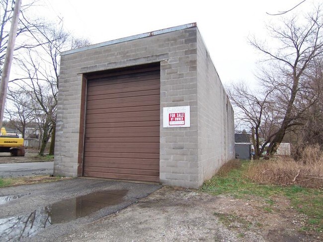
Property Detail
2 Brook St
New York-Jersey City-White Plains, NY-NJ
Passaic
13-00436-0000-00002
New Jersey
Shipyard
2
B and X Area of moderate flood hazard, usually the area between the limits of the 100-year and 500-year floods.
0.07 AC
2024
Suburban Passaic
2025
Northern New Jersey
236601
NEARBY LISTINGS FOR SALE OR LEASE
DEMOGRAPHICS near 2 Brook St
1 mile
3 mile
5 mile
2025 Total Population
5,452
42,743
105,777
2030 Population
5,629
44,212
109,464
Pop Growth 2025-2030
+ 3.25%
+ 3.44%
+ 3.49%
Average Age
42
44
44
2025 Total Households
1,929
16,623
39,269
HH Growth 2025-2030
+ 3.16%
+ 3.35%
+ 3.34%
Median Household Inc
$103,942
$112,856
$128,150
Avg Household Size
2.70
2.50
2.60
2025 Avg HH Vehicles
2.00
2.00
2.00
Median Home Value
$361,243
$430,035
$490,582
Median Year Built
1957
1965
1966
Nearby Places
Map Layers
Map Styles
 Street
 Aerial
Layers
 Traffic
 Biking
Places
Listings with unknown addresses are not visible on the map
- Restaurants
- Banks
- Shops
- Fitness
- Groceries
PUBLIC TRANSPORTATION
COMMUTER RAIL
Lincoln Park (Montclair-Boonton Line - NJ Transit Commuter Rail (NJ Transit))
Drive
Walk
Distance
Lincoln Park (Montclair-Boonton Line - NJ Transit Commuter Rail (NJ Transit))
14 min
8.1 mi
Mountain View (Montclair-Boonton Line - NJ Transit Commuter Rail (NJ Transit))
Drive
Walk
Distance
Mountain View (Montclair-Boonton Line - NJ Transit Commuter Rail (NJ Transit))
14 min
9.7 mi
AIRPORT
Newark Liberty International
Drive
Walk
Distance
Newark Liberty International
40 min
31.9 mi
LaGuardia
Drive
Walk
Distance
LaGuardia
52 min
35.5 mi
Westchester County
Drive
Walk
Distance
Westchester County
59 min
44.5 mi
Freight Ports
Maher Terminal
Drive
Walk
Distance
Maher Terminal
47 min
32.1 mi
Nearby Properties
Address
Land Use
TOTAL SIZE
Lot Size
Zoning
Address
Land Use
TOTAL SIZE
Lot Size
Zoning
Address
Land Use
TOTAL SIZE
Lot Size
Zoning
10.88 AC
Address
Land Use
TOTAL SIZE
Lot Size
Zoning
264,080 SF
44.44 AC
HB
Address
Land Use
TOTAL SIZE
Lot Size
Zoning
23.48 AC
Address
Land Use
TOTAL SIZE
Lot Size
Zoning
14.04 AC
B2
Address
Land Use
TOTAL SIZE
Lot Size
Zoning
10.42 AC
B2
Address
Land Use
TOTAL SIZE
Lot Size
Zoning
231.26 AC
PRC
Address
Land Use
TOTAL SIZE
Lot Size
Zoning
103,603 SF
12.12 AC
LI
Address
Land Use
TOTAL SIZE
Lot Size
Zoning
7.58 AC
R-4
Address
Land Use
TOTAL SIZE
Lot Size
Zoning
1,675.67 AC
Address
Land Use
TOTAL SIZE
Lot Size
Zoning
Address
Land Use
TOTAL SIZE
Lot Size
Zoning
8,978 SF
7.04 AC
R-4
Address
Land Use
TOTAL SIZE
Lot Size
Zoning
2.93 AC
B-5
Address
Land Use
TOTAL SIZE
Lot Size
Zoning
2.50 AC
B2
Address
Land Use
TOTAL SIZE
Lot Size
Zoning
67,570 SF
3.02 AC
SC
Address
Land Use
TOTAL SIZE
Lot Size
Zoning
357,779 SF
16.98 AC
Address
Land Use
TOTAL SIZE
Lot Size
Zoning
434 SF
53.04 AC
I-3
Address
Land Use
TOTAL SIZE
Lot Size
Zoning
103,650 SF
4.81 AC
I-1
Address
Land Use
TOTAL SIZE
Lot Size
Zoning
4.48 AC
R-6
Address
Land Use
TOTAL SIZE
Lot Size
Zoning
14.40 AC
Address
Land Use
TOTAL SIZE
Lot Size
Zoning
3.43 AC
B2
Address
Land Use
TOTAL SIZE
Lot Size
Zoning
88,929 SF
5.93 AC
I-1
Address
Land Use
TOTAL SIZE
Lot Size
Zoning
170.49 AC
AH-1
Address
Land Use
TOTAL SIZE
Lot Size
Zoning
44.65 AC
I-3
Address
Land Use
TOTAL SIZE
Lot Size
Zoning
8.33 AC
R-4
Address
Land Use
TOTAL SIZE
Lot Size
Zoning
26.10 AC
R15
Address
Land Use
TOTAL SIZE
Lot Size
Zoning
5.26 AC
RA3
Address
Land Use
TOTAL SIZE
Lot Size
Zoning
196.40 AC
C
Address
Land Use
TOTAL SIZE
Lot Size
Zoning
2.89 AC
B2
Address
Land Use
TOTAL SIZE
Lot Size
Zoning
4.20 AC
RA3
The World's #1 Commercial Real Estate Marketplace
Connect with us
© 2026 CoStar Group
The information above has been obtained from sources believed reliable. While we do not doubt its accuracy we have not verified it and make no guarantee, warranty or representation about it. It is your responsibility to independently confirm its accuracy and completeness. Any projections, opinions, assumptions, or estimates used are for example only and do not represent the current or future performance of the property. The value of this transaction to you depends on tax and other factors which should be evaluated by your tax, financial, and legal advisors. You and your advisors should conduct a careful, independent investigation of the property to determine to your satisfaction the suitability of the property for your needs.