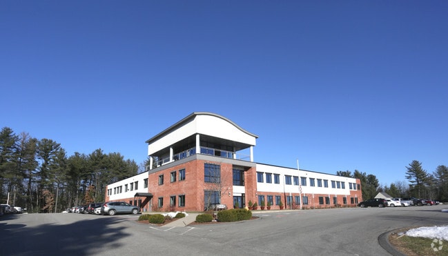
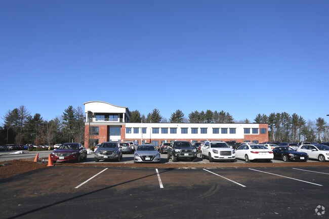
Property Record
2 Cooper Ln, Bedford, NH 03110

Property Detail
2 Cooper Ln
BEDD-000010-000023-000009
Hillsborough
Scientificpharmaceuticalmedicalresearchfacility
New Hampshire
CO
9
B and X Area of moderate flood hazard, usually the area between the limits of the 100-year and 500-year floods.
8.77 AC
2025
Hillsborough
2025
Boston
002902
Manchester-Nashua, NH
79,480 SF
NEARBY LISTINGS FOR SALE OR LEASE
DEMOGRAPHICS near 2 Cooper Ln
1 mile
3 mile
5 mile
2025 Total Population
3,699
52,205
131,449
2030 Population
3,833
52,660
132,495
Pop Growth 2025-2030
+ 3.62%
+ 0.87%
+ 0.80%
Average Age
44
40
40
2025 Total Households
1,326
20,508
52,794
HH Growth 2025-2030
+ 3.77%
+ 0.83%
+ 0.81%
Median Household Inc
$128,052
$90,027
$91,082
Avg Household Size
2.60
2.40
2.30
2025 Avg HH Vehicles
2.00
2.00
2.00
Median Home Value
$490,467
$398,361
$399,219
Median Year Built
1989
1969
1968
Nearby Places
Map Layers
Map Styles
 Street
 Aerial
Layers
 Traffic
 Biking
Places
Listings with unknown addresses are not visible on the map
- Restaurants
- Banks
- Shops
- Fitness
- Groceries
PUBLIC TRANSPORTATION
AIRPORT
Manchester Boston Regional
Drive
Walk
Distance
Manchester Boston Regional
15 min
6.3 mi
Freight Ports
Port of Boston
Drive
Walk
Distance
Port of Boston
87 min
58.7 mi
Nearby Properties
Address
Land Use
TOTAL SIZE
Lot Size
Zoning
Address
Land Use
TOTAL SIZE
Lot Size
Zoning
60,000 SF
144.50 AC
R2
Address
Land Use
TOTAL SIZE
Lot Size
Zoning
347,230 SF
42.11 AC
RA
Address
Land Use
TOTAL SIZE
Lot Size
Zoning
256,041 SF
6.69 AC
Address
Land Use
TOTAL SIZE
Lot Size
Zoning
Address
Land Use
TOTAL SIZE
Lot Size
Zoning
29,803 SF
31.46 AC
PZ
Address
Land Use
TOTAL SIZE
Lot Size
Zoning
3,748 SF
14.69 AC
Address
Land Use
TOTAL SIZE
Lot Size
Zoning
43,576 SF
0.13 AC
R2
Address
Land Use
TOTAL SIZE
Lot Size
Zoning
398,130 SF
1.68 AC
Address
Land Use
TOTAL SIZE
Lot Size
Zoning
22,101 SF
8.33 AC
Address
Land Use
TOTAL SIZE
Lot Size
Zoning
221,144 SF
3.77 AC
Address
Land Use
TOTAL SIZE
Lot Size
Zoning
207,701 SF
4.16 AC
Address
Land Use
TOTAL SIZE
Lot Size
Zoning
44,878 SF
12.89 AC
CO
Address
Land Use
TOTAL SIZE
Lot Size
Zoning
116,763 SF
7 AC
PZ
Address
Land Use
TOTAL SIZE
Lot Size
Zoning
2,656 SF
16.01 AC
Address
Land Use
TOTAL SIZE
Lot Size
Zoning
139,616 SF
18.47 AC
PZ
Address
Land Use
TOTAL SIZE
Lot Size
Zoning
165,000 SF
3.38 AC
Address
Land Use
TOTAL SIZE
Lot Size
Zoning
148,880 SF
2.38 AC
Address
Land Use
TOTAL SIZE
Lot Size
Zoning
95,643 SF
16 AC
RA
Address
Land Use
TOTAL SIZE
Lot Size
Zoning
42,795 SF
17.92 AC
Address
Land Use
TOTAL SIZE
Lot Size
Zoning
8,318 SF
8.71 AC
Address
Land Use
TOTAL SIZE
Lot Size
Zoning
515,760 SF
0.04 AC
Address
Land Use
TOTAL SIZE
Lot Size
Zoning
6,110 SF
12.99 AC
Address
Land Use
TOTAL SIZE
Lot Size
Zoning
130,851 SF
2.07 AC
Address
Land Use
TOTAL SIZE
Lot Size
Zoning
106,164 SF
3.89 AC
Address
Land Use
TOTAL SIZE
Lot Size
Zoning
50,954 SF
14.95 AC
R2
Address
Land Use
TOTAL SIZE
Lot Size
Zoning
35,364 SF
8.84 AC
PZ
Address
Land Use
TOTAL SIZE
Lot Size
Zoning
8,530 SF
26.33 AC
Address
Land Use
TOTAL SIZE
Lot Size
Zoning
1,710 SF
9.65 AC
R2
Address
Land Use
TOTAL SIZE
Lot Size
Zoning
72,932 SF
44.26 AC
Address
Land Use
TOTAL SIZE
Lot Size
Zoning
97,405 SF
14.40 AC
PZ
The World's #1 Commercial Real Estate Marketplace
Connect with us
© 2026 CoStar Group
The information above has been obtained from sources believed reliable. While we do not doubt its accuracy we have not verified it and make no guarantee, warranty or representation about it. It is your responsibility to independently confirm its accuracy and completeness. Any projections, opinions, assumptions, or estimates used are for example only and do not represent the current or future performance of the property. The value of this transaction to you depends on tax and other factors which should be evaluated by your tax, financial, and legal advisors. You and your advisors should conduct a careful, independent investigation of the property to determine to your satisfaction the suitability of the property for your needs.