Property Record
2 Dracut Rd, Hudson, NH 03051
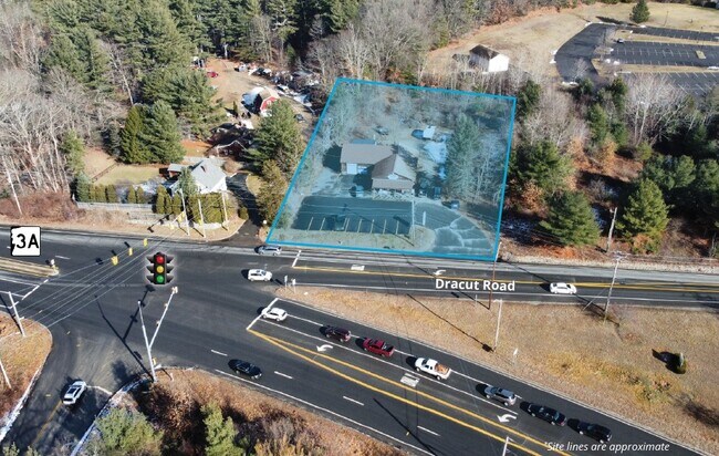

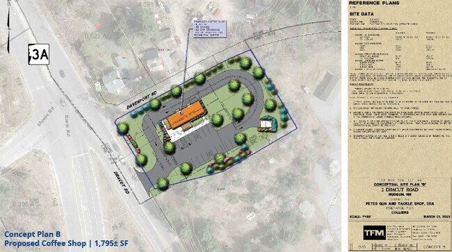
Property Detail
2 Dracut Rd
Storebuilding
HILLSBOROUGH
BD
New Hampshire
B and X Area of moderate flood hazard, usually the area between the limits of the 100-year and 500-year floods.
1.15 AC
2025
Hillsborough
2025
Boston
012302
Manchester-Nashua, NH
2,700 SF
HDSO-000234-000044
NEARBY LISTINGS FOR SALE OR LEASE
-
-
View all Hudson listings for lease on LoopNet.com
DEMOGRAPHICS near 2 Dracut Rd
1 mile
3 mile
5 mile
2025 Total Population
1,757
34,533
118,566
2030 Population
1,771
34,992
120,746
Pop Growth 2025-2030
+ 0.80%
+ 1.33%
+ 1.84%
Average Age
44
42
42
2025 Total Households
632
14,140
46,955
HH Growth 2025-2030
+ 0.79%
+ 1.36%
+ 1.87%
Median Household Inc
$146,139
$109,189
$105,711
Avg Household Size
2.70
2.40
2.50
2025 Avg HH Vehicles
3.00
2.00
2.00
Median Home Value
$471,686
$464,596
$453,434
Median Year Built
1977
1980
1977
Nearby Places
Map Layers
Map Styles
 Street
 Aerial
Layers
 Traffic
 Biking
Places
Listings with unknown addresses are not visible on the map
- Restaurants
- Banks
- Shops
- Fitness
- Groceries
PUBLIC TRANSPORTATION
COMMUTER RAIL
Lowell (Lowell Line - Massachusetts Bay Transportation Authority Commuter Rail (Purple Line))
Drive
Walk
Distance
Lowell (Lowell Line - Massachusetts Bay Transportation Authority Commuter Rail (Purple Line))
18 min
8.3 mi
AIRPORT
Manchester Boston Regional
Drive
Walk
Distance
Manchester Boston Regional
31 min
20.4 mi
General Edward Lawrence Logan International
Drive
Walk
Distance
General Edward Lawrence Logan International
63 min
38.6 mi
Freight Ports
Port of Boston
Drive
Walk
Distance
Port of Boston
63 min
38.3 mi
SALE & LEASE HISTORY
LISTING DATE
SALE/LEASE

Jul 08, 2024
For Lease
Nearby Properties
Address
Land Use
TOTAL SIZE
Lot Size
Zoning
Address
Land Use
TOTAL SIZE
Lot Size
Zoning
38.17 AC
RC
Address
Land Use
TOTAL SIZE
Lot Size
Zoning
29.77 AC
RC
Address
Land Use
TOTAL SIZE
Lot Size
Zoning
80.11 AC
PI
Address
Land Use
TOTAL SIZE
Lot Size
Zoning
27.98 AC
GI
Address
Land Use
TOTAL SIZE
Lot Size
Zoning
20.72 AC
RC
Address
Land Use
TOTAL SIZE
Lot Size
Zoning
522,476 SF
74.89 AC
ID
Address
Land Use
TOTAL SIZE
Lot Size
Zoning
15.19 AC
RC
Address
Land Use
TOTAL SIZE
Lot Size
Zoning
118.50 AC
PI
Address
Land Use
TOTAL SIZE
Lot Size
Zoning
20.80 AC
RC
Address
Land Use
TOTAL SIZE
Lot Size
Zoning
303,508 SF
171.19 AC
G1
Address
Land Use
TOTAL SIZE
Lot Size
Zoning
133,390 SF
97.42 AC
B
Address
Land Use
TOTAL SIZE
Lot Size
Zoning
52.45 AC
R18
Address
Land Use
TOTAL SIZE
Lot Size
Zoning
206,913 SF
18.30 AC
GB
Address
Land Use
TOTAL SIZE
Lot Size
Zoning
15.16 AC
GI
Address
Land Use
TOTAL SIZE
Lot Size
Zoning
21.40 AC
RC
Address
Land Use
TOTAL SIZE
Lot Size
Zoning
37.57 AC
R9
Address
Land Use
TOTAL SIZE
Lot Size
Zoning
153,922 SF
6.84 AC
GB
Address
Land Use
TOTAL SIZE
Lot Size
Zoning
312,738 SF
25.84 AC
ID
Address
Land Use
TOTAL SIZE
Lot Size
Zoning
127,494 SF
9.09 AC
GB
Address
Land Use
TOTAL SIZE
Lot Size
Zoning
12.55 AC
RC
Address
Land Use
TOTAL SIZE
Lot Size
Zoning
21.17 AC
RC
Address
Land Use
TOTAL SIZE
Lot Size
Zoning
185,242 SF
35.75 AC
ID
Address
Land Use
TOTAL SIZE
Lot Size
Zoning
8.09 AC
RC
Address
Land Use
TOTAL SIZE
Lot Size
Zoning
154,620 SF
8.63 AC
GB
Address
Land Use
TOTAL SIZE
Lot Size
Zoning
180,284 SF
16.13 AC
RB
Address
Land Use
TOTAL SIZE
Lot Size
Zoning
116,602 SF
11.74 AC
GB
Address
Land Use
TOTAL SIZE
Lot Size
Zoning
12.57 AC
RC
Address
Land Use
TOTAL SIZE
Lot Size
Zoning
233,668 SF
16.83 AC
PI
Address
Land Use
TOTAL SIZE
Lot Size
Zoning
144,018 SF
13.89 AC
PI
The World's #1 Commercial Real Estate Marketplace
Connect with us
© 2026 CoStar Group
The information above has been obtained from sources believed reliable. While we do not doubt its accuracy we have not verified it and make no guarantee, warranty or representation about it. It is your responsibility to independently confirm its accuracy and completeness. Any projections, opinions, assumptions, or estimates used are for example only and do not represent the current or future performance of the property. The value of this transaction to you depends on tax and other factors which should be evaluated by your tax, financial, and legal advisors. You and your advisors should conduct a careful, independent investigation of the property to determine to your satisfaction the suitability of the property for your needs.