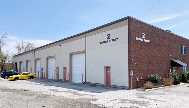
Property Record
2 Draper St, Woburn, MA 01801


Save to a Folder
{{folder.Name}}
{{folder.ListingIds.length}} Properties
{{folder.ListingIds.length}} Property
Create a New Folder
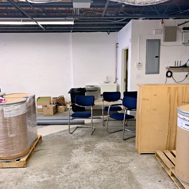
Property Detail
2 Draper St
WOBU-000053-000013-000026
Middlesex
Manufacturinglight
Massachusetts
I-G
26
B and X Area of moderate flood hazard, usually the area between the limits of the 100-year and 500-year floods.
0.62 AC
2025
Wilmington/Winchester
2025
Boston
333400
Boston-Cambridge-Newton, MA-NH
11,994 SF
NEARBY LISTINGS FOR SALE OR LEASE
DEMOGRAPHICS near 2 Draper St
1 mile
3 mile
5 mile
2025 Total Population
12,030
104,435
331,035
2030 Population
12,512
108,502
341,974
Pop Growth 2025-2030
+ 4.01%
+ 3.89%
+ 3.30%
Average Age
42
42
42
2025 Total Households
4,728
41,191
131,362
HH Growth 2025-2030
+ 4.12%
+ 4.04%
+ 3.42%
Median Household Inc
$120,262
$126,000
$125,068
Avg Household Size
2.50
2.50
2.40
2025 Avg HH Vehicles
2.00
2.00
2.00
Median Home Value
$788,043
$788,698
$785,742
Median Year Built
1967
1962
1956
Nearby Places
Map Layers
Map Styles
 Street
 Aerial
Layers
 Traffic
 Biking
Places
Listings with unknown addresses are not visible on the map
- Restaurants
- Banks
- Shops
- Fitness
- Groceries
PUBLIC TRANSPORTATION
COMMUTER RAIL
Winchester Center (Lowell Line - Massachusetts Bay Transportation Authority Commuter Rail (Purple Line))
Drive
Walk
Distance
Winchester Center (Lowell Line - Massachusetts Bay Transportation Authority Commuter Rail (Purple Line))
7 min
2.8 mi
Wedgemere (Lowell Line - Massachusetts Bay Transportation Authority Commuter Rail (Purple Line))
Drive
Walk
Distance
Wedgemere (Lowell Line - Massachusetts Bay Transportation Authority Commuter Rail (Purple Line))
9 min
3.6 mi
AIRPORT
General Edward Lawrence Logan International
Drive
Walk
Distance
General Edward Lawrence Logan International
20 min
12.9 mi
Freight Ports
Port of Boston
Drive
Walk
Distance
Port of Boston
21 min
12.6 mi
SALE & LEASE HISTORY
LISTING DATE
SALE/LEASE

Sep 25, 2016
For Lease
Nov 06, 2023
For Lease
May 20, 2024
For Lease
Jun 25, 2020
For Lease
Dec 05, 2017
For Lease
Apr 30, 2021
For Lease
Nearby Properties
Address
Land Use
TOTAL SIZE
Lot Size
Zoning
Address
Land Use
TOTAL SIZE
Lot Size
Zoning
169 AC
OS
Address
Land Use
TOTAL SIZE
Lot Size
Zoning
14.97 AC
C
Address
Land Use
TOTAL SIZE
Lot Size
Zoning
388,978 SF
23.23 AC
RG
Address
Land Use
TOTAL SIZE
Lot Size
Zoning
27.56 AC
R-2
Address
Land Use
TOTAL SIZE
Lot Size
Zoning
153,732 SF
12.50 AC
SCI
Address
Land Use
TOTAL SIZE
Lot Size
Zoning
476,332 SF
5.37 AC
Address
Land Use
TOTAL SIZE
Lot Size
Zoning
18.62 AC
O-P
Address
Land Use
TOTAL SIZE
Lot Size
Zoning
0.47 AC
M
Address
Land Use
TOTAL SIZE
Lot Size
Zoning
30.92 AC
RO
Address
Land Use
TOTAL SIZE
Lot Size
Zoning
720 SF
632 AC
SA8
Address
Land Use
TOTAL SIZE
Lot Size
Zoning
186,516 SF
40 AC
R-1
Address
Land Use
TOTAL SIZE
Lot Size
Zoning
31.56 AC
HB
Address
Land Use
TOTAL SIZE
Lot Size
Zoning
191,050 SF
3.15 AC
Address
Land Use
TOTAL SIZE
Lot Size
Zoning
9.01 AC
S-I
Address
Land Use
TOTAL SIZE
Lot Size
Zoning
341,593 SF
3.38 AC
I-P2
Address
Land Use
TOTAL SIZE
Lot Size
Zoning
9.50 AC
SCI
Address
Land Use
TOTAL SIZE
Lot Size
Zoning
127.30 AC
R-1
Address
Land Use
TOTAL SIZE
Lot Size
Zoning
27.90 AC
I-P2
Address
Land Use
TOTAL SIZE
Lot Size
Zoning
157,305 SF
10.69 AC
RDB
Address
Land Use
TOTAL SIZE
Lot Size
Zoning
17.65 AC
B-I
Address
Land Use
TOTAL SIZE
Lot Size
Zoning
5.63 AC
C
Address
Land Use
TOTAL SIZE
Lot Size
Zoning
8.17 AC
RB
Address
Land Use
TOTAL SIZE
Lot Size
Zoning
6.28 AC
RB
Address
Land Use
TOTAL SIZE
Lot Size
Zoning
216,337 SF
7.19 AC
S20
Address
Land Use
TOTAL SIZE
Lot Size
Zoning
9 AC
C/R
Address
Land Use
TOTAL SIZE
Lot Size
Zoning
68,876 SF
17.10 AC
R-1
Address
Land Use
TOTAL SIZE
Lot Size
Zoning
14,760 SF
1 AC
SR
Address
Land Use
TOTAL SIZE
Lot Size
Zoning
15.85 AC
R-3
Address
Land Use
TOTAL SIZE
Lot Size
Zoning
53,415 SF
11.02 AC
SCI
Address
Land Use
TOTAL SIZE
Lot Size
Zoning
481,812 SF
25.97 AC
I-P2
The World's #1 Commercial Real Estate Marketplace
Connect with us
© 2026 CoStar Group
The information above has been obtained from sources believed reliable. While we do not doubt its accuracy we have not verified it and make no guarantee, warranty or representation about it. It is your responsibility to independently confirm its accuracy and completeness. Any projections, opinions, assumptions, or estimates used are for example only and do not represent the current or future performance of the property. The value of this transaction to you depends on tax and other factors which should be evaluated by your tax, financial, and legal advisors. You and your advisors should conduct a careful, independent investigation of the property to determine to your satisfaction the suitability of the property for your needs.