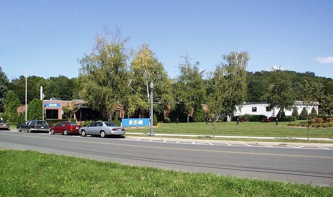
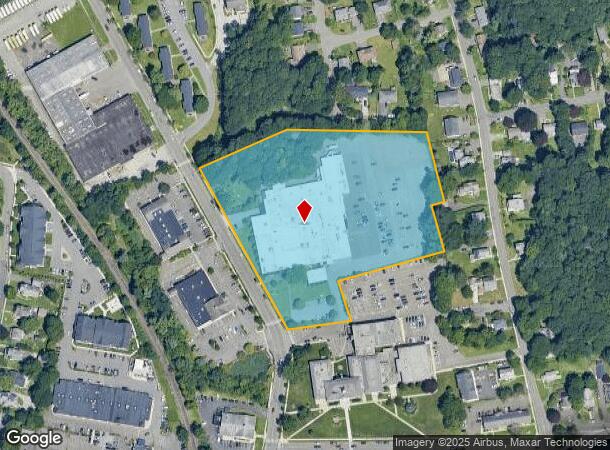
Property Record
2 Durant Ave, Bethel, CT 06801
NEARBY LISTINGS FOR SALE OR LEASE
Property Detail
2 Durant Ave
BETH-000022-000037A-000001
Fairfield
Manufacturinglight
Connecticut
X
1
09001C0231F
6.54 AC
2024
Bethel
2025
Westchester/So Connecticut
200200
Bridgeport-Stamford-Danbury, CT
67,288 SF
DEMOGRAPHICS near 2 Durant Ave
1 Mile
3 Mile
5 Mile
2024 Total Population
10,039
55,026
103,219
2029 Population
9,943
54,563
102,784
Pop Growth 2024-2029
(0.96%)
(0.84%)
(0.42%)
Average Age
41
39
40
2024 Total Households
4,068
20,269
37,553
HH Growth 2024-2029
(1.01%)
(0.93%)
(0.52%)
Median Household Inc
$74,737
$71,775
$83,198
Avg Household Size
2.50
2.60
2.60
2024 Avg HH Vehicles
2.00
2.00
2.00
Median Home Value
$362,756
$339,810
$362,573
Median Year Built
1972
1969
1972
Nearby Places
Map Layers
Map Styles
 Street
 Aerial
- Restaurants
- Banks
- Shops
- Fitness
- Groceries
PUBLIC TRANSPORTATION
COMMUTER RAIL
Bethel Station (New Haven Line - Metro-North Commuter Railroad Company (Metro-North))
DRIVE
WALK
Distance
Bethel Station (New Haven Line - Metro-North Commuter Railroad Company (Metro-North))
1 min
5 min
0.3 mi
Danbury Station (New Haven Line - Metro-North Commuter Railroad Company (Metro-North))
DRIVE
WALK
Distance
Danbury Station (New Haven Line - Metro-North Commuter Railroad Company (Metro-North))
7 min
3.2 mi
AIRPORT
Westchester County
DRIVE
WALK
Distance
Westchester County
51 min
37.2 mi
Tweed/New Haven
DRIVE
WALK
Distance
Tweed/New Haven
61 min
37.5 mi
Freight Ports
Port of New Haven
DRIVE
WALK
Distance
Port of New Haven
56 min
34.6 mi
Nearby Properties
Address
Land Use
TOTAL SIZE
Lot Size
Zoning
Address
Land Use
TOTAL SIZE
Lot Size
Zoning
9.04 AC
CCBD
Address
Land Use
TOTAL SIZE
Lot Size
Zoning
297,318 SF
18.16 AC
IG80
Address
Land Use
TOTAL SIZE
Lot Size
Zoning
86,646 SF
122.26 AC
R-40
Address
Land Use
TOTAL SIZE
Lot Size
Zoning
7.98 AC
RH3
Address
Land Use
TOTAL SIZE
Lot Size
Zoning
7,769 SF
17.75 AC
RA-20
Address
Land Use
TOTAL SIZE
Lot Size
Zoning
33.50 AC
CG-20
Address
Land Use
TOTAL SIZE
Lot Size
Zoning
95,976 SF
4.14 AC
RH3
Address
Land Use
TOTAL SIZE
Lot Size
Zoning
137,884 SF
16.96 AC
1L40
Address
Land Use
TOTAL SIZE
Lot Size
Zoning
42.36 AC
R-3
Address
Land Use
TOTAL SIZE
Lot Size
Zoning
158,981 SF
12.79 AC
RA20
Address
Land Use
TOTAL SIZE
Lot Size
Zoning
45.78 AC
RM12
Address
Land Use
TOTAL SIZE
Lot Size
Zoning
7.28 AC
RH3
Address
Land Use
TOTAL SIZE
Lot Size
Zoning
47,564 SF
4.45 AC
CCBD
Address
Land Use
TOTAL SIZE
Lot Size
Zoning
17.24 AC
IL-40
Address
Land Use
TOTAL SIZE
Lot Size
Zoning
198,560 SF
3.30 AC
CLCB
Address
Land Use
TOTAL SIZE
Lot Size
Zoning
10.51 AC
IL40
Address
Land Use
TOTAL SIZE
Lot Size
Zoning
12.51 AC
IL40
Address
Land Use
TOTAL SIZE
Lot Size
Zoning
49.57 AC
CG-20
Address
Land Use
TOTAL SIZE
Lot Size
Zoning
58,000 SF
2.90 AC
RH3
Address
Land Use
TOTAL SIZE
Lot Size
Zoning
24.50 AC
RA8
Address
Land Use
TOTAL SIZE
Lot Size
Zoning
5.12 AC
CLCB
Address
Land Use
TOTAL SIZE
Lot Size
Zoning
304,561 SF
5.02 AC
IL40
Address
Land Use
TOTAL SIZE
Lot Size
Zoning
8,756 SF
8.10 AC
IL40
Address
Land Use
TOTAL SIZE
Lot Size
Zoning
55,229 SF
7 AC
R3
Address
Land Use
TOTAL SIZE
Lot Size
Zoning
92,843 SF
9.74 AC
CG20
Address
Land Use
TOTAL SIZE
Lot Size
Zoning
3.08 AC
CG-20
Address
Land Use
TOTAL SIZE
Lot Size
Zoning
7.85 AC
RA-20
Address
Land Use
TOTAL SIZE
Lot Size
Zoning
2.86 AC
RH3
Address
Land Use
TOTAL SIZE
Lot Size
Zoning
107,256 SF
2.67 AC
CLCB
Address
Land Use
TOTAL SIZE
Lot Size
Zoning
56,658 SF
12 AC
RA40
The World's #1 Commercial Real Estate Marketplace
Connect with us
© 2026 CoStar Group
The information above has been obtained from sources believed reliable. While we do not doubt its accuracy we have not verified it and make no guarantee, warranty or representation about it. It is your responsibility to independently confirm its accuracy and completeness. Any projections, opinions, assumptions, or estimates used are for example only and do not represent the current or future performance of the property. The value of this transaction to you depends on tax and other factors which should be evaluated by your tax, financial, and legal advisors. You and your advisors should conduct a careful, independent investigation of the property to determine to your satisfaction the suitability of the property for your needs.