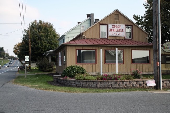
Property Record
2 E 28Th Division Hwy, Lititz, PA 17543

Current Lease Availabilities
Property Detail
2 E 28Th Division Hwy
Commercialnec
Lancaster
HC
Pennsylvania
B and X Area of moderate flood hazard, usually the area between the limits of the 100-year and 500-year floods.
6.07 AC
2024
Lancaster County
2025
Philadelphia
010201
Lancaster, PA
17,920 SF
240-67949-0-0000
NEARBY LISTINGS FOR SALE OR LEASE
-
-
View all Lititz listings for lease on LoopNet.com
DEMOGRAPHICS near 2 E 28Th Division Hwy
1 mile
3 mile
5 mile
2025 Total Population
954
7,671
27,838
2030 Population
957
7,719
28,178
Pop Growth 2025-2030
+ 0.31%
+ 0.63%
+ 1.22%
Average Age
41
41
42
2025 Total Households
337
2,758
10,533
HH Growth 2025-2030
+ 0.30%
+ 0.69%
+ 1.24%
Median Household Inc
$93,269
$93,239
$86,038
Avg Household Size
2.80
2.70
2.60
2025 Avg HH Vehicles
2.00
2.00
2.00
Median Home Value
$342,623
$339,850
$322,774
Median Year Built
1978
1981
1981
Nearby Places
Map Layers
Map Styles
 Street
 Aerial
Layers
 Traffic
 Biking
Places
Listings with unknown addresses are not visible on the map
- Restaurants
- Banks
- Shops
- Fitness
- Groceries
PUBLIC TRANSPORTATION
AIRPORT
Harrisburg International
Drive
Walk
Distance
Harrisburg International
44 min
33.2 mi
Freight Ports
Port of Wilmington, RI
Drive
Walk
Distance
Port of Wilmington, RI
103 min
69.1 mi
Nearby Properties
Address
Land Use
TOTAL SIZE
Lot Size
Zoning
Address
Land Use
TOTAL SIZE
Lot Size
Zoning
102,392 SF
21.77 AC
Address
Land Use
TOTAL SIZE
Lot Size
Zoning
86,947 SF
6.30 AC
A
Address
Land Use
TOTAL SIZE
Lot Size
Zoning
11,970 SF
577.39 AC
C
Address
Land Use
TOTAL SIZE
Lot Size
Zoning
12,191 SF
174.80 AC
A
Address
Land Use
TOTAL SIZE
Lot Size
Zoning
5,744 SF
247 AC
C
Address
Land Use
TOTAL SIZE
Lot Size
Zoning
471.60 AC
C
Address
Land Use
TOTAL SIZE
Lot Size
Zoning
10,691 SF
116.58 AC
R
Address
Land Use
TOTAL SIZE
Lot Size
Zoning
7,049 SF
195.90 AC
A
Address
Land Use
TOTAL SIZE
Lot Size
Zoning
12,762 SF
77.96 AC
AT
Address
Land Use
TOTAL SIZE
Lot Size
Zoning
5,999 SF
163.68 AC
Address
Land Use
TOTAL SIZE
Lot Size
Zoning
18,509 SF
5.59 AC
Address
Land Use
TOTAL SIZE
Lot Size
Zoning
4,478 SF
190.60 AC
A
Address
Land Use
TOTAL SIZE
Lot Size
Zoning
38,758 SF
43.13 AC
HC
Address
Land Use
TOTAL SIZE
Lot Size
Zoning
18,970 SF
4.72 AC
HC
Address
Land Use
TOTAL SIZE
Lot Size
Zoning
17,400 SF
6.70 AC
R
Address
Land Use
TOTAL SIZE
Lot Size
Zoning
8,837 SF
65.90 AC
Address
Land Use
TOTAL SIZE
Lot Size
Zoning
9,068 SF
61.20 AC
A
Address
Land Use
TOTAL SIZE
Lot Size
Zoning
7,884 SF
107.56 AC
AG
Address
Land Use
TOTAL SIZE
Lot Size
Zoning
4,958 SF
110.90 AC
A
Address
Land Use
TOTAL SIZE
Lot Size
Zoning
14,010 SF
6.31 AC
Address
Land Use
TOTAL SIZE
Lot Size
Zoning
24,586 SF
32.20 AC
C
Address
Land Use
TOTAL SIZE
Lot Size
Zoning
4,998 SF
116.70 AC
AT
Address
Land Use
TOTAL SIZE
Lot Size
Zoning
6,134 SF
114.60 AC
A
Address
Land Use
TOTAL SIZE
Lot Size
Zoning
4,278 SF
102.10 AC
A
Address
Land Use
TOTAL SIZE
Lot Size
Zoning
3,550 SF
103.45 AC
A
Address
Land Use
TOTAL SIZE
Lot Size
Zoning
43,555 SF
8.68 AC
CC
Address
Land Use
TOTAL SIZE
Lot Size
Zoning
5,178 SF
90.12 AC
AT
Address
Land Use
TOTAL SIZE
Lot Size
Zoning
4,394 SF
85.80 AC
AG
Address
Land Use
TOTAL SIZE
Lot Size
Zoning
133 AC
C
Address
Land Use
TOTAL SIZE
Lot Size
Zoning
4,254 SF
82.90 AC
AG
The World's #1 Commercial Real Estate Marketplace
Connect with us
© 2026 CoStar Group
The information above has been obtained from sources believed reliable. While we do not doubt its accuracy we have not verified it and make no guarantee, warranty or representation about it. It is your responsibility to independently confirm its accuracy and completeness. Any projections, opinions, assumptions, or estimates used are for example only and do not represent the current or future performance of the property. The value of this transaction to you depends on tax and other factors which should be evaluated by your tax, financial, and legal advisors. You and your advisors should conduct a careful, independent investigation of the property to determine to your satisfaction the suitability of the property for your needs.