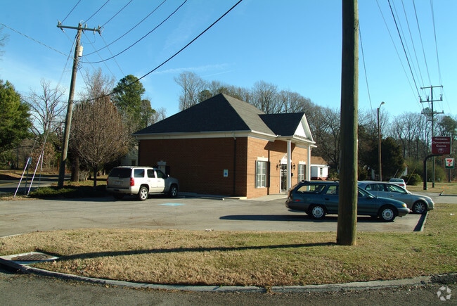
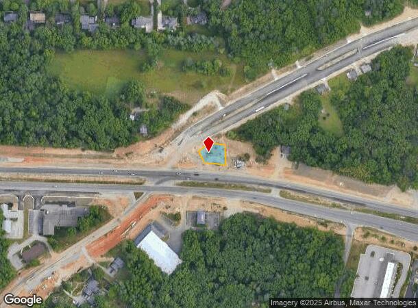
Property Record
2 E Hundred Rd, Chester, VA 23836


NEARBY LISTINGS FOR SALE OR LEASE
Property Detail
2 E Hundred Rd
Richmond, VA
Westover Farms
814-65-20-68-600-000
WESTOVER FARMS PT LT 1
Commercialnec
Chesterfield
X
Virginia
51041C0351E
1
2025
0.20 AC
2025
South Chesterfield
100403
Richmond VA
1,334 SF
DEMOGRAPHICS near 2 E Hundred Rd
1 Mile
3 Mile
5 Mile
2024 Total Population
4,805
21,674
62,799
2029 Population
5,260
23,873
67,433
Pop Growth 2024-2029
+ 9.47%
+ 10.15%
+ 7.38%
Average Age
39
39
40
2024 Total Households
1,665
7,745
22,215
HH Growth 2024-2029
+ 9.49%
+ 10.19%
+ 7.78%
Median Household Inc
$97,324
$87,252
$75,865
Avg Household Size
2.80
2.70
2.60
2024 Avg HH Vehicles
2.00
2.00
2.00
Median Home Value
$315,392
$306,292
$262,339
Median Year Built
1995
1994
1989
Nearby Places
Map Layers
Map Styles
 Street
 Aerial
- Restaurants
- Banks
- Shops
- Fitness
- Groceries
PUBLIC TRANSPORTATION
AIRPORT
Richmond International
DRIVE
WALK
Distance
Richmond International
26 min
16.9 mi
Freight Ports
Virginia Port Authority - Richmond
DRIVE
WALK
Distance
Virginia Port Authority - Richmond
20 min
12.3 mi
Nearby Properties
Address
Land Use
TOTAL SIZE
Lot Size
Zoning
Address
Land Use
TOTAL SIZE
Lot Size
Zoning
99.30 AC
I2 - GEN I
Address
Land Use
TOTAL SIZE
Lot Size
Zoning
440,100 SF
82.70 AC
I2 - GEN I
Address
Land Use
TOTAL SIZE
Lot Size
Zoning
557,533 SF
48.60 AC
I2 - GEN I
Address
Land Use
TOTAL SIZE
Lot Size
Zoning
41,930 SF
23.04 AC
C5 - GEN B
Address
Land Use
TOTAL SIZE
Lot Size
Zoning
88,847 SF
93.02 AC
A - AGRICU
Address
Land Use
TOTAL SIZE
Lot Size
Zoning
32,947 SF
13.38 AC
C5 - GEN B
Address
Land Use
TOTAL SIZE
Lot Size
Zoning
100 SF
36.88 AC
RMF - RES,
Address
Land Use
TOTAL SIZE
Lot Size
Zoning
49,595 SF
28.14 AC
I2 - GEN I
Address
Land Use
TOTAL SIZE
Lot Size
Zoning
352,800 SF
54.30 AC
I2 - GEN I
Address
Land Use
TOTAL SIZE
Lot Size
Zoning
81,138 SF
27.31 AC
C2 - NBHD
Address
Land Use
TOTAL SIZE
Lot Size
Zoning
177,908 SF
13.59 AC
RMF - RES,
Address
Land Use
TOTAL SIZE
Lot Size
Zoning
100 SF
14.70 AC
C5 - GEN B
Address
Land Use
TOTAL SIZE
Lot Size
Zoning
404,200 SF
62.22 AC
I2 - GEN I
Address
Land Use
TOTAL SIZE
Lot Size
Zoning
296,000 SF
42.39 AC
I2 - GEN I
Address
Land Use
TOTAL SIZE
Lot Size
Zoning
241,800 SF
16.96 AC
I2 - GEN I
Address
Land Use
TOTAL SIZE
Lot Size
Zoning
242,042 SF
10.15 AC
I2 - GEN I
Address
Land Use
TOTAL SIZE
Lot Size
Zoning
91,105 SF
10.90 AC
C3 - COMMU
Address
Land Use
TOTAL SIZE
Lot Size
Zoning
340.76 AC
I2 - GEN I
Address
Land Use
TOTAL SIZE
Lot Size
Zoning
261,922 SF
19.85 AC
I1 - LT IN
Address
Land Use
TOTAL SIZE
Lot Size
Zoning
3,946 SF
17.72 AC
R15 - SING
Address
Land Use
TOTAL SIZE
Lot Size
Zoning
260,928 SF
19.40 AC
I1 - LT IN
Address
Land Use
TOTAL SIZE
Lot Size
Zoning
194,000 SF
175.55 AC
I1 - LT IN
Address
Land Use
TOTAL SIZE
Lot Size
Zoning
187,980 SF
15.31 AC
I1 - LT IN
Address
Land Use
TOTAL SIZE
Lot Size
Zoning
173,800 SF
15.99 AC
I2 - GEN I
Address
Land Use
TOTAL SIZE
Lot Size
Zoning
490,345 SF
101.57 AC
I2 - GEN I
Address
Land Use
TOTAL SIZE
Lot Size
Zoning
92,905 SF
49.45 AC
A - AGRICU
Address
Land Use
TOTAL SIZE
Lot Size
Zoning
13,567 SF
17.96 AC
C5 - GEN B
Address
Land Use
TOTAL SIZE
Lot Size
Zoning
203,544 SF
15.17 AC
I1 - LT IN
Address
Land Use
TOTAL SIZE
Lot Size
Zoning
47.44 AC
MH1 - MOBI
Address
Land Use
TOTAL SIZE
Lot Size
Zoning
0.01 AC
MH1 - MOBI
The World's #1 Commercial Real Estate Marketplace
Connect with us
© 2025 CoStar Group
The information above has been obtained from sources believed reliable. While we do not doubt its accuracy we have not verified it and make no guarantee, warranty or representation about it. It is your responsibility to independently confirm its accuracy and completeness. Any projections, opinions, assumptions, or estimates used are for example only and do not represent the current or future performance of the property. The value of this transaction to you depends on tax and other factors which should be evaluated by your tax, financial, and legal advisors. You and your advisors should conduct a careful, independent investigation of the property to determine to your satisfaction the suitability of the property for your needs.