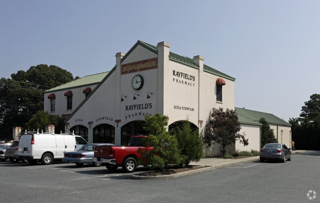
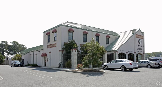
Property Record
2 Fig St, Cape Charles, VA 23310

Property Detail
2 Fig St
83A4-A-21
ANNEX - ICE PLANT MASON AVE. ANNEX - ICE PLANT MASON AVE.
Storebuilding
Northampton
B and X Area of moderate flood hazard, usually the area between the limits of the 100-year and 500-year floods.
Virginia
2025
1 AC
2025
Virginia Regional
930301
Other Market Areas
NEARBY LISTINGS FOR SALE OR LEASE
-
-
View all Cape Charles listings for lease on LoopNet.com
DEMOGRAPHICS near 2 Fig St
1 mile
3 mile
5 mile
2025 Total Population
2,445
3,988
5,386
2030 Population
2,749
4,316
5,702
Pop Growth 2025-2030
+ 12.43%
+ 8.22%
+ 5.87%
Average Age
49
49
48
2025 Total Households
1,209
1,919
2,511
HH Growth 2025-2030
+ 12.32%
+ 8.44%
+ 6.21%
Median Household Inc
$54,268
$55,650
$55,728
Avg Household Size
2.00
2.00
2.10
2025 Avg HH Vehicles
1.00
2.00
2.00
Median Home Value
$540,948
$448,139
$395,950
Median Year Built
2001
2000
1993
Nearby Places
Map Layers
Map Styles
 Street
 Aerial
Layers
 Traffic
 Biking
Places
Listings with unknown addresses are not visible on the map
- Restaurants
- Banks
- Shops
- Fitness
- Groceries
PUBLIC TRANSPORTATION
AIRPORT
Norfolk International
Drive
Walk
Distance
Norfolk International
58 min
38.8 mi
Freight Ports
Virginia Port Authority - Portsmouth
Drive
Walk
Distance
Virginia Port Authority - Portsmouth
73 min
45.4 mi
SALE & LEASE HISTORY
LISTING DATE
SALE/LEASE

Sep 25, 2016
For Lease
Nearby Properties
Address
Land Use
TOTAL SIZE
Lot Size
Zoning
Address
Land Use
TOTAL SIZE
Lot Size
Zoning
Address
Land Use
TOTAL SIZE
Lot Size
Zoning
17.05 AC
Address
Land Use
TOTAL SIZE
Lot Size
Zoning
Address
Land Use
TOTAL SIZE
Lot Size
Zoning
Address
Land Use
TOTAL SIZE
Lot Size
Zoning
6.82 AC
Address
Land Use
TOTAL SIZE
Lot Size
Zoning
95.61 AC
LU
Address
Land Use
TOTAL SIZE
Lot Size
Zoning
Address
Land Use
TOTAL SIZE
Lot Size
Zoning
40.82 AC
Address
Land Use
TOTAL SIZE
Lot Size
Zoning
Address
Land Use
TOTAL SIZE
Lot Size
Zoning
18.40 AC
Address
Land Use
TOTAL SIZE
Lot Size
Zoning
5.26 AC
Address
Land Use
TOTAL SIZE
Lot Size
Zoning
0.37 AC
Address
Land Use
TOTAL SIZE
Lot Size
Zoning
56.46 AC
Address
Land Use
TOTAL SIZE
Lot Size
Zoning
6,033 SF
0.42 AC
Address
Land Use
TOTAL SIZE
Lot Size
Zoning
5,124 SF
0.46 AC
Address
Land Use
TOTAL SIZE
Lot Size
Zoning
4,436 SF
0.26 AC
Address
Land Use
TOTAL SIZE
Lot Size
Zoning
4,722 SF
0.28 AC
Address
Land Use
TOTAL SIZE
Lot Size
Zoning
4,685 SF
0.28 AC
Address
Land Use
TOTAL SIZE
Lot Size
Zoning
5,809 SF
0.28 AC
Address
Land Use
TOTAL SIZE
Lot Size
Zoning
5,344 SF
0.29 AC
Address
Land Use
TOTAL SIZE
Lot Size
Zoning
Address
Land Use
TOTAL SIZE
Lot Size
Zoning
7,486 SF
0.21 AC
Address
Land Use
TOTAL SIZE
Lot Size
Zoning
Address
Land Use
TOTAL SIZE
Lot Size
Zoning
6,096 SF
1 AC
Address
Land Use
TOTAL SIZE
Lot Size
Zoning
3,838 SF
0.28 AC
Address
Land Use
TOTAL SIZE
Lot Size
Zoning
2,396 SF
0.28 AC
Address
Land Use
TOTAL SIZE
Lot Size
Zoning
6,000 SF
109.92 AC
LU
Address
Land Use
TOTAL SIZE
Lot Size
Zoning
38.59 AC
Address
Land Use
TOTAL SIZE
Lot Size
Zoning
The World's #1 Commercial Real Estate Marketplace
Connect with us
© 2026 CoStar Group
The information above has been obtained from sources believed reliable. While we do not doubt its accuracy we have not verified it and make no guarantee, warranty or representation about it. It is your responsibility to independently confirm its accuracy and completeness. Any projections, opinions, assumptions, or estimates used are for example only and do not represent the current or future performance of the property. The value of this transaction to you depends on tax and other factors which should be evaluated by your tax, financial, and legal advisors. You and your advisors should conduct a careful, independent investigation of the property to determine to your satisfaction the suitability of the property for your needs.