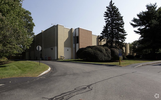
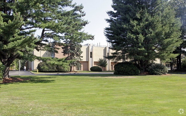
Property Record
2 Forbes Rd, Lexington, MA 02421

Property Detail
2 Forbes Rd
LEXI-000043-000000-000009C
Middlesex
Industrialgeneral
Massachusetts
ND
9c
B and X Area of moderate flood hazard, usually the area between the limits of the 100-year and 500-year floods.
20.03 AC
2025
Lexington/Arlington
2025
Boston
358400
Boston-Cambridge-Newton, MA-NH
99,226 SF
NEARBY LISTINGS FOR SALE OR LEASE
DEMOGRAPHICS near 2 Forbes Rd
1 mile
3 mile
5 mile
2025 Total Population
4,487
45,158
151,723
2030 Population
4,677
47,171
158,054
Pop Growth 2025-2030
+ 4.23%
+ 4.46%
+ 4.17%
Average Age
41
42
42
2025 Total Households
1,497
16,312
56,102
HH Growth 2025-2030
+ 4.21%
+ 4.50%
+ 4.34%
Median Household Inc
$192,764
$183,600
$156,513
Avg Household Size
3.00
2.70
2.60
2025 Avg HH Vehicles
2.00
2.00
2.00
Median Home Value
$1,091,404
$1,039,327
$921,927
Median Year Built
1962
1967
1964
Nearby Places
Map Layers
Map Styles
 Street
 Aerial
Transit
 Traffic
 Biking
Places
Listings with unknown addresses are not visible on the map
- Restaurants
- Banks
- Shops
- Fitness
- Groceries
PUBLIC TRANSPORTATION
COMMUTER RAIL
Lincoln (Fitchburg/South Acton Line - Massachusetts Bay Transportation Authority Commuter Rail (Purple Line))
Drive
Walk
Distance
Lincoln (Fitchburg/South Acton Line - Massachusetts Bay Transportation Authority Commuter Rail (Purple Line))
11 min
5.2 mi
Kendal Green (Fitchburg/South Acton Line - Massachusetts Bay Transportation Authority Commuter Rail (Purple Line))
Drive
Walk
Distance
Kendal Green (Fitchburg/South Acton Line - Massachusetts Bay Transportation Authority Commuter Rail (Purple Line))
12 min
5.6 mi
AIRPORT
General Edward Lawrence Logan International
Drive
Walk
Distance
General Edward Lawrence Logan International
32 min
18.0 mi
Manchester Boston Regional
Drive
Walk
Distance
Manchester Boston Regional
66 min
45.0 mi
Worcester Regional
Drive
Walk
Distance
Worcester Regional
65 min
45.1 mi
Freight Ports
Port of Boston
Drive
Walk
Distance
Port of Boston
32 min
18.0 mi
Nearby Properties
Address
Land Use
TOTAL SIZE
Lot Size
Zoning
Address
Land Use
TOTAL SIZE
Lot Size
Zoning
776,099 SF
35.70 AC
Address
Land Use
TOTAL SIZE
Lot Size
Zoning
561,437 SF
33.53 AC
Address
Land Use
TOTAL SIZE
Lot Size
Zoning
190,308 SF
17.46 AC
CD
Address
Land Use
TOTAL SIZE
Lot Size
Zoning
198,051 SF
11.56 AC
CR
Address
Land Use
TOTAL SIZE
Lot Size
Zoning
336,306 SF
7.54 AC
Address
Land Use
TOTAL SIZE
Lot Size
Zoning
25,000 SF
25.73 AC
RD
Address
Land Use
TOTAL SIZE
Lot Size
Zoning
914,941 SF
30.97 AC
R1
Address
Land Use
TOTAL SIZE
Lot Size
Zoning
282,014 SF
15.57 AC
Address
Land Use
TOTAL SIZE
Lot Size
Zoning
345,794 SF
24.17 AC
IND
Address
Land Use
TOTAL SIZE
Lot Size
Zoning
175,158 SF
54.36 AC
Address
Land Use
TOTAL SIZE
Lot Size
Zoning
442,743 SF
27.11 AC
Address
Land Use
TOTAL SIZE
Lot Size
Zoning
342,677 SF
56.46 AC
ND
Address
Land Use
TOTAL SIZE
Lot Size
Zoning
21.99 AC
Address
Land Use
TOTAL SIZE
Lot Size
Zoning
11.25 AC
CR
Address
Land Use
TOTAL SIZE
Lot Size
Zoning
224,892 SF
20.52 AC
Address
Land Use
TOTAL SIZE
Lot Size
Zoning
286,462 SF
15.94 AC
Address
Land Use
TOTAL SIZE
Lot Size
Zoning
210,423 SF
26.39 AC
Address
Land Use
TOTAL SIZE
Lot Size
Zoning
618.53 AC
Address
Land Use
TOTAL SIZE
Lot Size
Zoning
278,150 SF
16.84 AC
Address
Land Use
TOTAL SIZE
Lot Size
Zoning
120,704 SF
15.03 AC
CD
Address
Land Use
TOTAL SIZE
Lot Size
Zoning
208,900 SF
25.26 AC
Address
Land Use
TOTAL SIZE
Lot Size
Zoning
100,271 SF
13.25 AC
CM
Address
Land Use
TOTAL SIZE
Lot Size
Zoning
11.25 AC
CR
Address
Land Use
TOTAL SIZE
Lot Size
Zoning
276,000 SF
16.90 AC
RO
Address
Land Use
TOTAL SIZE
Lot Size
Zoning
160,722 SF
15.63 AC
ND
Address
Land Use
TOTAL SIZE
Lot Size
Zoning
176,664 SF
16.66 AC
Address
Land Use
TOTAL SIZE
Lot Size
Zoning
162,659 SF
11.11 AC
Address
Land Use
TOTAL SIZE
Lot Size
Zoning
145,298 SF
20 AC
RS
Address
Land Use
TOTAL SIZE
Lot Size
Zoning
297,389 SF
16 AC
ND
Address
Land Use
TOTAL SIZE
Lot Size
Zoning
229,982 SF
24.97 AC
CR
The World's #1 Commercial Real Estate Marketplace
Connect with us
© 2026 CoStar Group
The information above has been obtained from sources believed reliable. While we do not doubt its accuracy we have not verified it and make no guarantee, warranty or representation about it. It is your responsibility to independently confirm its accuracy and completeness. Any projections, opinions, assumptions, or estimates used are for example only and do not represent the current or future performance of the property. The value of this transaction to you depends on tax and other factors which should be evaluated by your tax, financial, and legal advisors. You and your advisors should conduct a careful, independent investigation of the property to determine to your satisfaction the suitability of the property for your needs.