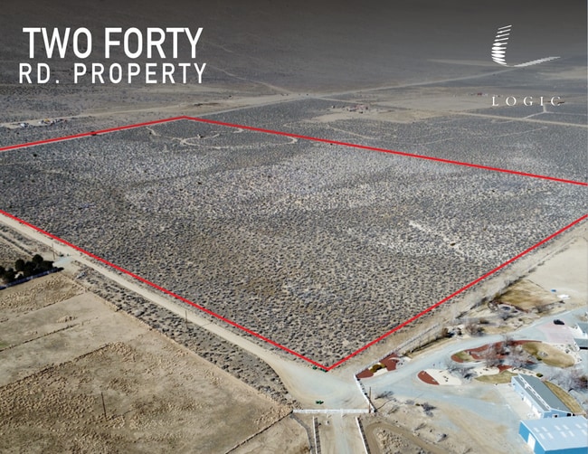
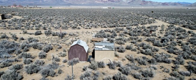
Property Record
2 Forty Rd, Reno, NV 89510


Property Detail
2 Forty Rd
076-110-36
DLM 1 PAR 35.3.0.7
Residentialacreage
WASHOE
GRA
Nevada
B and X Area of moderate flood hazard, usually the area between the limits of the 100-year and 500-year floods.
59.87 AC
0
N Outlying Washoe County
2026
Reno/Sparks
003501
Reno, NV
NEARBY LISTINGS FOR SALE OR LEASE
-
-
View all Reno listings for sale on LoopNet.com
DEMOGRAPHICS near 2 Forty Rd
1 mile
3 mile
5 mile
2025 Total Population
78
421
774
2030 Population
83
449
825
Pop Growth 2025-2030
+ 6.41%
+ 6.65%
+ 6.59%
Average Age
44
45
45
2025 Total Households
27
149
274
HH Growth 2025-2030
+ 7.41%
+ 6.71%
+ 6.57%
Median Household Inc
$97,499
$96,758
$97,249
Avg Household Size
2.80
2.60
2.60
2025 Avg HH Vehicles
3.00
3.00
3.00
Median Home Value
$687,500
$691,176
$685,897
Median Year Built
1999
1999
1999
Nearby Places
Map Layers
Map Styles
 Street
 Aerial
Layers
 Traffic
 Biking
Places
Listings with unknown addresses are not visible on the map
- Restaurants
- Banks
- Shops
- Fitness
- Groceries
PUBLIC TRANSPORTATION
AIRPORT
Reno/Tahoe International
Drive
Walk
Distance
Reno/Tahoe International
53 min
28.2 mi
Freight Ports
Port of Stockton
Drive
Walk
Distance
Port of Stockton
238 min
202.5 mi
SALE & LEASE HISTORY
LISTING DATE
SALE/LEASE

Apr 26, 2022
For Sale
Nearby Properties
Address
Land Use
TOTAL SIZE
Lot Size
Zoning
Address
Land Use
TOTAL SIZE
Lot Size
Zoning
75,629 SF
38.78 AC
NC 14% / M
Address
Land Use
TOTAL SIZE
Lot Size
Zoning
3,528 SF
2.14 AC
NC
Address
Land Use
TOTAL SIZE
Lot Size
Zoning
5,000 SF
40.66 AC
GRA
Address
Land Use
TOTAL SIZE
Lot Size
Zoning
3,200 SF
72.86 AC
GRA
Address
Land Use
TOTAL SIZE
Lot Size
Zoning
152 AC
GRA
Address
Land Use
TOTAL SIZE
Lot Size
Zoning
1,152 SF
41.86 AC
GRA
Address
Land Use
TOTAL SIZE
Lot Size
Zoning
64.91 AC
GRA
Address
Land Use
TOTAL SIZE
Lot Size
Zoning
67.92 AC
GRA
Address
Land Use
TOTAL SIZE
Lot Size
Zoning
42.25 AC
GRA
Address
Land Use
TOTAL SIZE
Lot Size
Zoning
40 AC
GRA
Address
Land Use
TOTAL SIZE
Lot Size
Zoning
66.45 AC
GRA
Address
Land Use
TOTAL SIZE
Lot Size
Zoning
57.05 AC
GRA
Address
Land Use
TOTAL SIZE
Lot Size
Zoning
42.59 AC
GRA
Address
Land Use
TOTAL SIZE
Lot Size
Zoning
80 AC
GR
Address
Land Use
TOTAL SIZE
Lot Size
Zoning
45.45 AC
NC 32% / M
Address
Land Use
TOTAL SIZE
Lot Size
Zoning
45.57 AC
NC 85% / G
Address
Land Use
TOTAL SIZE
Lot Size
Zoning
198.13 AC
GRA
Address
Land Use
TOTAL SIZE
Lot Size
Zoning
3,258 SF
44.53 AC
GRA
Address
Land Use
TOTAL SIZE
Lot Size
Zoning
40.91 AC
GRA
Address
Land Use
TOTAL SIZE
Lot Size
Zoning
40.93 AC
GRA
Address
Land Use
TOTAL SIZE
Lot Size
Zoning
40.72 AC
GRA
Address
Land Use
TOTAL SIZE
Lot Size
Zoning
41.80 AC
GRA
Address
Land Use
TOTAL SIZE
Lot Size
Zoning
41.80 AC
GRA
Address
Land Use
TOTAL SIZE
Lot Size
Zoning
40.59 AC
GRA
Address
Land Use
TOTAL SIZE
Lot Size
Zoning
41.70 AC
GRA
Address
Land Use
TOTAL SIZE
Lot Size
Zoning
41.49 AC
GRA
Address
Land Use
TOTAL SIZE
Lot Size
Zoning
40.87 AC
GRA
Address
Land Use
TOTAL SIZE
Lot Size
Zoning
69.33 AC
GRA
Address
Land Use
TOTAL SIZE
Lot Size
Zoning
40.50 AC
GRA
The World's #1 Commercial Real Estate Marketplace
Connect with us
© 2026 CoStar Group
The information above has been obtained from sources believed reliable. While we do not doubt its accuracy we have not verified it and make no guarantee, warranty or representation about it. It is your responsibility to independently confirm its accuracy and completeness. Any projections, opinions, assumptions, or estimates used are for example only and do not represent the current or future performance of the property. The value of this transaction to you depends on tax and other factors which should be evaluated by your tax, financial, and legal advisors. You and your advisors should conduct a careful, independent investigation of the property to determine to your satisfaction the suitability of the property for your needs.