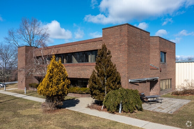
Property Record
26 Milan Rd, Brewster, NY 10509

Property Detail
26 Milan Rd
373089-045-000-0001-021-000-0000
PUTNAM
Warehouse
New York
OP1
21.00
B and X Area of moderate flood hazard, usually the area between the limits of the 100-year and 500-year floods.
4.64 AC
2024
Brewster
2025
Westchester/So Connecticut
011900
New York-Jersey City-White Plains, NY-NJ
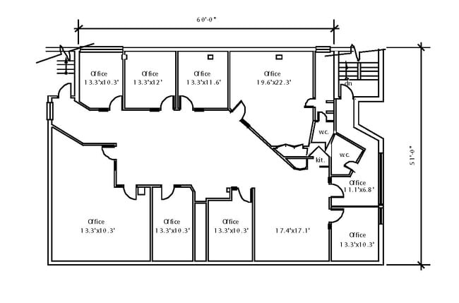
46,940 SF
NEARBY LISTINGS FOR SALE OR LEASE
DEMOGRAPHICS near 26 Milan Rd
1 mile
3 mile
5 mile
2025 Total Population
331
22,769
41,655
2030 Population
332
22,746
41,669
Pop Growth 2025-2030
+ 0.30%
(0.10%)
+ 0.03%
Average Age
45
44
44
2025 Total Households
137
8,541
15,285
HH Growth 2025-2030
0.00%
(0.07%)
+ 0.04%
Median Household Inc
$98,369
$110,697
$117,954
Avg Household Size
2.40
2.60
2.60
2025 Avg HH Vehicles
2.00
2.00
2.00
Median Home Value
$366,666
$425,724
$435,298
Median Year Built
1988
1973
1972
Nearby Places
Map Layers
Map Styles
 Street
 Aerial
Layers
 Traffic
 Biking
Places
Listings with unknown addresses are not visible on the map
- Restaurants
- Banks
- Shops
- Fitness
- Groceries
PUBLIC TRANSPORTATION
COMMUTER RAIL
Southeast Station (Harlem Line - Metro-North Commuter Railroad Company (Metro-North))
Drive
Walk
Distance
Southeast Station (Harlem Line - Metro-North Commuter Railroad Company (Metro-North))
8 min
2.1 mi
Brewster Station (Harlem Line - Metro-North Commuter Railroad Company (Metro-North))
Drive
Walk
Distance
Brewster Station (Harlem Line - Metro-North Commuter Railroad Company (Metro-North))
7 min
4.0 mi
AIRPORT
Westchester County
Drive
Walk
Distance
Westchester County
38 min
28.9 mi
New York Stewart International
Drive
Walk
Distance
New York Stewart International
47 min
34.1 mi
Freight Ports
Port of New Haven
Drive
Walk
Distance
Port of New Haven
71 min
48.6 mi
SALE & LEASE HISTORY
LISTING DATE
SALE/LEASE

Sep 25, 2016
For Lease
Jan 26, 2022
For Sale
Aug 30, 2021
For Lease
Nearby Properties
Address
Land Use
TOTAL SIZE
Lot Size
Zoning
Address
Land Use
TOTAL SIZE
Lot Size
Zoning
670.72 AC
SP Z
Address
Land Use
TOTAL SIZE
Lot Size
Zoning
5,328 SF
808.45 AC
R60
Address
Land Use
TOTAL SIZE
Lot Size
Zoning
290,658 SF
50.83 AC
R160
Address
Land Use
TOTAL SIZE
Lot Size
Zoning
618,786 SF
164.46 AC
OP3
Address
Land Use
TOTAL SIZE
Lot Size
Zoning
159,857 SF
12.34 AC
R
Address
Land Use
TOTAL SIZE
Lot Size
Zoning
170,015 SF
70.32 AC
R160
Address
Land Use
TOTAL SIZE
Lot Size
Zoning
223,335 SF
27.56 AC
OP2
Address
Land Use
TOTAL SIZE
Lot Size
Zoning
146,484 SF
23.06 AC
SR 22
Address
Land Use
TOTAL SIZE
Lot Size
Zoning
186,972 SF
17.77 AC
C
Address
Land Use
TOTAL SIZE
Lot Size
Zoning
116,000 SF
13.29 AC
SP Z
Address
Land Use
TOTAL SIZE
Lot Size
Zoning
150,100 SF
7.52 AC
C
Address
Land Use
TOTAL SIZE
Lot Size
Zoning
Address
Land Use
TOTAL SIZE
Lot Size
Zoning
303,100 SF
64.48 AC
OP3
Address
Land Use
TOTAL SIZE
Lot Size
Zoning
122,538 SF
29.02 AC
MWFH
Address
Land Use
TOTAL SIZE
Lot Size
Zoning
144,300 SF
25.97 AC
C
Address
Land Use
TOTAL SIZE
Lot Size
Zoning
48,811 SF
11.66 AC
OP2
Address
Land Use
TOTAL SIZE
Lot Size
Zoning
97,708 SF
11.42 AC
OP2
Address
Land Use
TOTAL SIZE
Lot Size
Zoning
0.01 AC
OP3
Address
Land Use
TOTAL SIZE
Lot Size
Zoning
22,338 SF
2.37 AC
C
Address
Land Use
TOTAL SIZE
Lot Size
Zoning
150,000 SF
10.40 AC
OP2
Address
Land Use
TOTAL SIZE
Lot Size
Zoning
Address
Land Use
TOTAL SIZE
Lot Size
Zoning
131,719 SF
19.05 AC
OP2
Address
Land Use
TOTAL SIZE
Lot Size
Zoning
69,500 SF
12 AC
CBP
Address
Land Use
TOTAL SIZE
Lot Size
Zoning
2.03 AC
C
Address
Land Use
TOTAL SIZE
Lot Size
Zoning
116,593 SF
11.23 AC
HC
Address
Land Use
TOTAL SIZE
Lot Size
Zoning
116,349 SF
14.49 AC
R4
Address
Land Use
TOTAL SIZE
Lot Size
Zoning
63,221 SF
10 AC
SP Z
Address
Land Use
TOTAL SIZE
Lot Size
Zoning
66,037 SF
1.61 AC
R
Address
Land Use
TOTAL SIZE
Lot Size
Zoning
29,369 SF
19.29 AC
SP Z
Address
Land Use
TOTAL SIZE
Lot Size
Zoning
43,175 SF
0.83 AC
C
The World's #1 Commercial Real Estate Marketplace
Connect with us
© 2026 CoStar Group
The information above has been obtained from sources believed reliable. While we do not doubt its accuracy we have not verified it and make no guarantee, warranty or representation about it. It is your responsibility to independently confirm its accuracy and completeness. Any projections, opinions, assumptions, or estimates used are for example only and do not represent the current or future performance of the property. The value of this transaction to you depends on tax and other factors which should be evaluated by your tax, financial, and legal advisors. You and your advisors should conduct a careful, independent investigation of the property to determine to your satisfaction the suitability of the property for your needs.