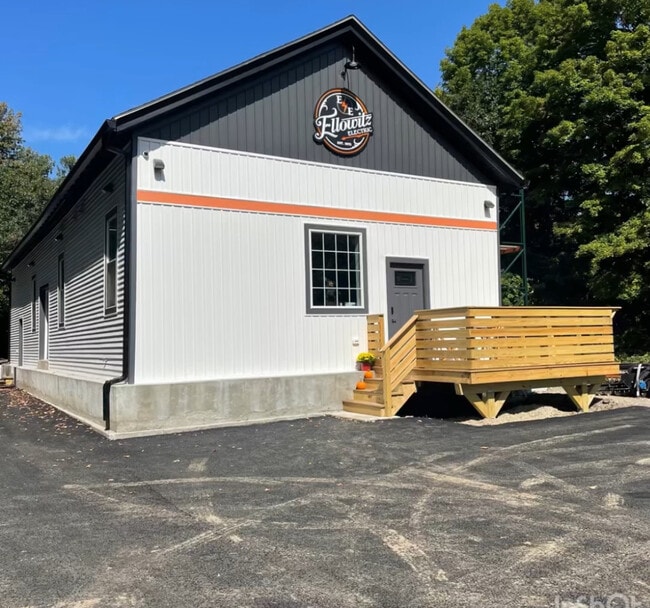
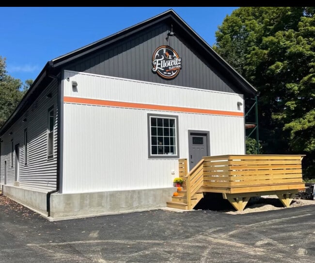
Property Record
2 Goodale St, West Boylston, MA 01583

NEARBY LISTINGS FOR SALE OR LEASE
-
-
View all West Boylston listings for sale on LoopNet.com
Property Detail
2 Goodale St
Departmentstore
Worcester
X
Massachusetts
25027C0606F
0.90 AC
2025
Outlying Worcester
2025
Boston
729100
Worcester, MA-CT
889 SF
WBOY-000143-000068
DEMOGRAPHICS near 2 Goodale St
1 Mile
3 Mile
5 Mile
2024 Total Population
1,724
14,038
61,169
2029 Population
1,717
13,932
60,816
Pop Growth 2024-2029
(0.41%)
(0.76%)
(0.58%)
Average Age
44
44
42
2024 Total Households
673
5,300
23,570
HH Growth 2024-2029
(0.45%)
(0.72%)
(0.68%)
Median Household Inc
$102,107
$103,392
$98,042
Avg Household Size
2.40
2.50
2.50
2024 Avg HH Vehicles
2.00
2.00
2.00
Median Home Value
$389,622
$384,668
$384,009
Median Year Built
1963
1968
1962
Nearby Places
Map Layers
Map Styles
 Street
 Aerial
- Restaurants
- Banks
- Shops
- Fitness
- Groceries
PUBLIC TRANSPORTATION
COMMUTER RAIL
Worcester Union Station (Lake Shore Limited - Amtrak)
DRIVE
WALK
Distance
Worcester Union Station (Lake Shore Limited - Amtrak)
14 min
8.6 mi
Worcester (Framingham/Worcester Line - Massachusetts Bay Transportation Authority Commuter Rail (Purple Line))
DRIVE
WALK
Distance
Worcester (Framingham/Worcester Line - Massachusetts Bay Transportation Authority Commuter Rail (Purple Line))
15 min
8.6 mi
AIRPORT
Worcester Regional
DRIVE
WALK
Distance
Worcester Regional
24 min
13.0 mi
Freight Ports
Port of Boston
DRIVE
WALK
Distance
Port of Boston
69 min
50.7 mi
SALE & LEASE HISTORY
LISTING DATE
SALE/LEASE

Mar 25, 2025
For Sale
Nearby Properties
Address
Land Use
TOTAL SIZE
Lot Size
Zoning
Address
Land Use
TOTAL SIZE
Lot Size
Zoning
83,889 SF
12.47 AC
R20
Address
Land Use
TOTAL SIZE
Lot Size
Zoning
6.88 AC
Address
Land Use
TOTAL SIZE
Lot Size
Zoning
Address
Land Use
TOTAL SIZE
Lot Size
Zoning
5.46 AC
BL-1
Address
Land Use
TOTAL SIZE
Lot Size
Zoning
102,067 SF
24.17 AC
Address
Land Use
TOTAL SIZE
Lot Size
Zoning
71,871 SF
22.87 AC
Address
Land Use
TOTAL SIZE
Lot Size
Zoning
1,529 SF
48.30 AC
Address
Land Use
TOTAL SIZE
Lot Size
Zoning
3,719 SF
106.92 AC
Address
Land Use
TOTAL SIZE
Lot Size
Zoning
18,888 SF
10.71 AC
RL-7
Address
Land Use
TOTAL SIZE
Lot Size
Zoning
147,200 SF
16.07 AC
Address
Land Use
TOTAL SIZE
Lot Size
Zoning
105,125 SF
9 AC
Address
Land Use
TOTAL SIZE
Lot Size
Zoning
2,888 SF
26.29 AC
Address
Land Use
TOTAL SIZE
Lot Size
Zoning
180,418 SF
14.92 AC
Address
Land Use
TOTAL SIZE
Lot Size
Zoning
93,606 SF
8.40 AC
Address
Land Use
TOTAL SIZE
Lot Size
Zoning
37,977 SF
4.58 AC
Address
Land Use
TOTAL SIZE
Lot Size
Zoning
550.26 AC
Address
Land Use
TOTAL SIZE
Lot Size
Zoning
3,120 SF
1.67 AC
BL-1
Address
Land Use
TOTAL SIZE
Lot Size
Zoning
70,963 SF
3.60 AC
Address
Land Use
TOTAL SIZE
Lot Size
Zoning
161,964 SF
10 AC
Address
Land Use
TOTAL SIZE
Lot Size
Zoning
52,780 SF
5.55 AC
Address
Land Use
TOTAL SIZE
Lot Size
Zoning
7.87 AC
RL-7
Address
Land Use
TOTAL SIZE
Lot Size
Zoning
75,691 SF
11.63 AC
Address
Land Use
TOTAL SIZE
Lot Size
Zoning
134.91 AC
Address
Land Use
TOTAL SIZE
Lot Size
Zoning
102,799 SF
14.62 AC
Address
Land Use
TOTAL SIZE
Lot Size
Zoning
49,752 SF
8.20 AC
Address
Land Use
TOTAL SIZE
Lot Size
Zoning
13,617 SF
9.41 AC
R-15
Address
Land Use
TOTAL SIZE
Lot Size
Zoning
38,921 SF
31.58 AC
Address
Land Use
TOTAL SIZE
Lot Size
Zoning
50,952 SF
5.24 AC
Address
Land Use
TOTAL SIZE
Lot Size
Zoning
8,680 SF
2.97 AC
Address
Land Use
TOTAL SIZE
Lot Size
Zoning
1.12 AC
RL-7
The World's #1 Commercial Real Estate Marketplace
Connect with us
© 2025 CoStar Group
The information above has been obtained from sources believed reliable. While we do not doubt its accuracy we have not verified it and make no guarantee, warranty or representation about it. It is your responsibility to independently confirm its accuracy and completeness. Any projections, opinions, assumptions, or estimates used are for example only and do not represent the current or future performance of the property. The value of this transaction to you depends on tax and other factors which should be evaluated by your tax, financial, and legal advisors. You and your advisors should conduct a careful, independent investigation of the property to determine to your satisfaction the suitability of the property for your needs.