Property Record
2 Groton St, Lawrence, MA 01843

Save to a Folder
{{folder.Name}}
{{folder.ListingIds.length}} Properties
{{folder.ListingIds.length}} Property
Create a New Folder
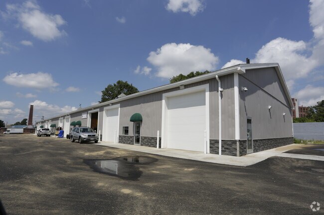
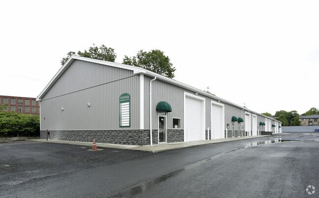
Property Detail
2 Groton St
Boston-Cambridge-Newton, MA-NH
ESSEX
LAWR-000098-000000-000025-000003-000003
Massachusetts
Commercialnec
25 3
B and X Area of moderate flood hazard, usually the area between the limits of the 100-year and 500-year floods.
1.82 AC
2025
Lawrence/Andover
2025
Boston
251500
NEARBY LISTINGS FOR SALE OR LEASE
DEMOGRAPHICS near 2 Groton St
1 mile
3 mile
5 mile
2025 Total Population
25,419
142,341
199,115
2030 Population
25,452
143,533
201,936
Pop Growth 2025-2030
+ 0.13%
+ 0.84%
+ 1.42%
Average Age
36
38
39
2025 Total Households
8,534
49,116
69,438
HH Growth 2025-2030
+ 0.23%
+ 1.07%
+ 1.54%
Median Household Inc
$72,755
$73,811
$89,663
Avg Household Size
2.90
2.70
2.70
2025 Avg HH Vehicles
1.00
2.00
2.00
Median Home Value
$407,935
$504,452
$595,665
Median Year Built
1949
1955
1964
Nearby Places
Map Layers
Map Styles
 Street
 Aerial
Layers
 Traffic
 Biking
Places
Listings with unknown addresses are not visible on the map
- Restaurants
- Banks
- Shops
- Fitness
- Groceries
PUBLIC TRANSPORTATION
COMMUTER RAIL
Lawrence (Haverhill Line - Massachusetts Bay Transportation Authority Commuter Rail (Purple Line))
Drive
Walk
Distance
Lawrence (Haverhill Line - Massachusetts Bay Transportation Authority Commuter Rail (Purple Line))
3 min
1.5 mi
Andover (Haverhill Line - Massachusetts Bay Transportation Authority Commuter Rail (Purple Line))
Drive
Walk
Distance
Andover (Haverhill Line - Massachusetts Bay Transportation Authority Commuter Rail (Purple Line))
5 min
2.5 mi
AIRPORT
Manchester Boston Regional
Drive
Walk
Distance
Manchester Boston Regional
43 min
27.0 mi
General Edward Lawrence Logan International
Drive
Walk
Distance
General Edward Lawrence Logan International
40 min
29.2 mi
Portsmouth International at Pease
Drive
Walk
Distance
Portsmouth International at Pease
53 min
38.8 mi
SALE & LEASE HISTORY
LISTING DATE
SALE/LEASE

Sep 25, 2016
For Lease
Nearby Properties
Address
Land Use
TOTAL SIZE
Lot Size
Zoning
Address
Land Use
TOTAL SIZE
Lot Size
Zoning
25.50 AC
IA
Address
Land Use
TOTAL SIZE
Lot Size
Zoning
10.40 AC
ID
Address
Land Use
TOTAL SIZE
Lot Size
Zoning
6,680 SF
84.07 AC
R2
Address
Land Use
TOTAL SIZE
Lot Size
Zoning
9,576 SF
56.95 AC
R3
Address
Land Use
TOTAL SIZE
Lot Size
Zoning
10.38 AC
Address
Land Use
TOTAL SIZE
Lot Size
Zoning
3,111 SF
42.18 AC
R5
Address
Land Use
TOTAL SIZE
Lot Size
Zoning
24 AC
ID
Address
Land Use
TOTAL SIZE
Lot Size
Zoning
15,621 SF
34 AC
R5
Address
Land Use
TOTAL SIZE
Lot Size
Zoning
204,300 SF
5.48 AC
Address
Land Use
TOTAL SIZE
Lot Size
Zoning
335,482 SF
7.61 AC
Address
Land Use
TOTAL SIZE
Lot Size
Zoning
240,639 SF
2.65 AC
Address
Land Use
TOTAL SIZE
Lot Size
Zoning
22.55 AC
IA
Address
Land Use
TOTAL SIZE
Lot Size
Zoning
237,705 SF
33.49 AC
ID
Address
Land Use
TOTAL SIZE
Lot Size
Zoning
16.56 AC
Address
Land Use
TOTAL SIZE
Lot Size
Zoning
87.72 AC
SRB
Address
Land Use
TOTAL SIZE
Lot Size
Zoning
48.33 AC
ID
Address
Land Use
TOTAL SIZE
Lot Size
Zoning
170,116 SF
11.14 AC
Address
Land Use
TOTAL SIZE
Lot Size
Zoning
472,045 SF
72.30 AC
HD
Address
Land Use
TOTAL SIZE
Lot Size
Zoning
196,152 SF
20.20 AC
ID2
Address
Land Use
TOTAL SIZE
Lot Size
Zoning
43.36 AC
ID2
Address
Land Use
TOTAL SIZE
Lot Size
Zoning
8.59 AC
IS
Address
Land Use
TOTAL SIZE
Lot Size
Zoning
4.33 AC
MU
Address
Land Use
TOTAL SIZE
Lot Size
Zoning
71,785 SF
29 AC
R4
Address
Land Use
TOTAL SIZE
Lot Size
Zoning
332,500 SF
3.17 AC
Address
Land Use
TOTAL SIZE
Lot Size
Zoning
7.13 AC
Address
Land Use
TOTAL SIZE
Lot Size
Zoning
8,738 SF
30.59 AC
R4
Address
Land Use
TOTAL SIZE
Lot Size
Zoning
Address
Land Use
TOTAL SIZE
Lot Size
Zoning
322,858 SF
15.97 AC
ID
Address
Land Use
TOTAL SIZE
Lot Size
Zoning
28.05 AC
SRB
Address
Land Use
TOTAL SIZE
Lot Size
Zoning
162,978 SF
13.73 AC
ID2
The World's #1 Commercial Real Estate Marketplace
Connect with us
© 2026 CoStar Group
The information above has been obtained from sources believed reliable. While we do not doubt its accuracy we have not verified it and make no guarantee, warranty or representation about it. It is your responsibility to independently confirm its accuracy and completeness. Any projections, opinions, assumptions, or estimates used are for example only and do not represent the current or future performance of the property. The value of this transaction to you depends on tax and other factors which should be evaluated by your tax, financial, and legal advisors. You and your advisors should conduct a careful, independent investigation of the property to determine to your satisfaction the suitability of the property for your needs.