Property Record
2 Hill Rd, Franklin, NH 03235
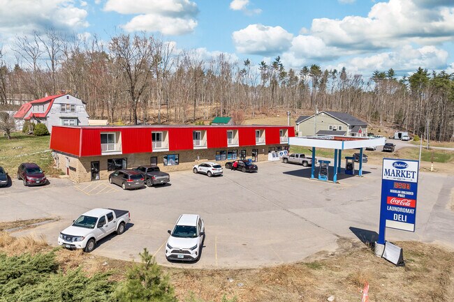


Property Detail
2 Hill Rd
Commercialbuilding
Merrimack
B1W&S
New Hampshire
B and X Area of moderate flood hazard, usually the area between the limits of the 100-year and 500-year floods.
0.69 AC
2025
Concord/New Hampshire North Area
2025
Other Market Areas
043002
Concord, NH
7,333 SF
FRKN-000096-000104
NEARBY LISTINGS FOR SALE OR LEASE
DEMOGRAPHICS near 2 Hill Rd
1 mile
3 mile
5 mile
2025 Total Population
2,913
10,126
17,103
2030 Population
3,025
10,435
17,462
Pop Growth 2025-2030
+ 3.84%
+ 3.05%
+ 2.10%
Average Age
44
43
43
2025 Total Households
1,246
4,180
6,977
HH Growth 2025-2030
+ 3.77%
+ 3.04%
+ 2.05%
Median Household Inc
$80,816
$75,733
$78,588
Avg Household Size
2.30
2.30
2.40
2025 Avg HH Vehicles
2.00
2.00
2.00
Median Home Value
$258,176
$270,941
$282,579
Median Year Built
1964
1962
1969
Nearby Places
Map Layers
Map Styles
 Street
 Aerial
Layers
 Traffic
 Biking
Places
Listings with unknown addresses are not visible on the map
- Restaurants
- Banks
- Shops
- Fitness
- Groceries
SALE & LEASE HISTORY
LISTING DATE
SALE/LEASE

Mar 20, 2025
For Sale
Apr 23, 2024
For Sale
Nearby Properties
Address
Land Use
TOTAL SIZE
Lot Size
Zoning
Address
Land Use
TOTAL SIZE
Lot Size
Zoning
149,800 SF
28 AC
MEDIUM
Address
Land Use
TOTAL SIZE
Lot Size
Zoning
118,611 SF
12.40 AC
VILLAG
Address
Land Use
TOTAL SIZE
Lot Size
Zoning
64,666 SF
8.65 AC
RSW&S
Address
Land Use
TOTAL SIZE
Lot Size
Zoning
Address
Land Use
TOTAL SIZE
Lot Size
Zoning
16,833 SF
2.39 AC
B1W&S
Address
Land Use
TOTAL SIZE
Lot Size
Zoning
93,102 SF
8.21 AC
GENERA
Address
Land Use
TOTAL SIZE
Lot Size
Zoning
83,283 SF
16.81 AC
RSW&S
Address
Land Use
TOTAL SIZE
Lot Size
Zoning
94,330 SF
14.70 AC
B1W&S
Address
Land Use
TOTAL SIZE
Lot Size
Zoning
215,790 SF
18 AC
I1
Address
Land Use
TOTAL SIZE
Lot Size
Zoning
54,592 SF
B1W&S
Address
Land Use
TOTAL SIZE
Lot Size
Zoning
6.75 AC
GENERA
Address
Land Use
TOTAL SIZE
Lot Size
Zoning
2,032 SF
59.56 AC
MEDIUM
Address
Land Use
TOTAL SIZE
Lot Size
Zoning
2,324 SF
388 AC
C
Address
Land Use
TOTAL SIZE
Lot Size
Zoning
44,129 SF
13.23 AC
RSW&S
Address
Land Use
TOTAL SIZE
Lot Size
Zoning
4,832 SF
1.37 AC
R3W&S
Address
Land Use
TOTAL SIZE
Lot Size
Zoning
65,308 SF
2.27 AC
B2
Address
Land Use
TOTAL SIZE
Lot Size
Zoning
44,955 SF
5.22 AC
B1W&S
Address
Land Use
TOTAL SIZE
Lot Size
Zoning
31,620 SF
8.12 AC
RSW&S
Address
Land Use
TOTAL SIZE
Lot Size
Zoning
143,583 SF
25.99 AC
I1W&S
Address
Land Use
TOTAL SIZE
Lot Size
Zoning
44,678 SF
1.40 AC
B2
Address
Land Use
TOTAL SIZE
Lot Size
Zoning
8,234 SF
5.70 AC
R2W&S
Address
Land Use
TOTAL SIZE
Lot Size
Zoning
40,321 SF
11.20 AC
R2W&S
Address
Land Use
TOTAL SIZE
Lot Size
Zoning
25,274 SF
1.40 AC
B2
Address
Land Use
TOTAL SIZE
Lot Size
Zoning
9,321 SF
3.50 AC
R2W&S
Address
Land Use
TOTAL SIZE
Lot Size
Zoning
16,647 SF
1.20 AC
B2
Address
Land Use
TOTAL SIZE
Lot Size
Zoning
8,247 SF
3.50 AC
RS
Address
Land Use
TOTAL SIZE
Lot Size
Zoning
74,989 SF
14.90 AC
I1W&S
Address
Land Use
TOTAL SIZE
Lot Size
Zoning
1,980 SF
48.93 AC
R1W&S
Address
Land Use
TOTAL SIZE
Lot Size
Zoning
26,237 SF
0.93 AC
B2
Address
Land Use
TOTAL SIZE
Lot Size
Zoning
119,862 SF
4.51 AC
B2
The World's #1 Commercial Real Estate Marketplace
Connect with us
© 2026 CoStar Group
The information above has been obtained from sources believed reliable. While we do not doubt its accuracy we have not verified it and make no guarantee, warranty or representation about it. It is your responsibility to independently confirm its accuracy and completeness. Any projections, opinions, assumptions, or estimates used are for example only and do not represent the current or future performance of the property. The value of this transaction to you depends on tax and other factors which should be evaluated by your tax, financial, and legal advisors. You and your advisors should conduct a careful, independent investigation of the property to determine to your satisfaction the suitability of the property for your needs.