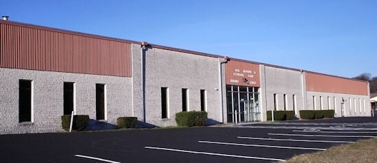
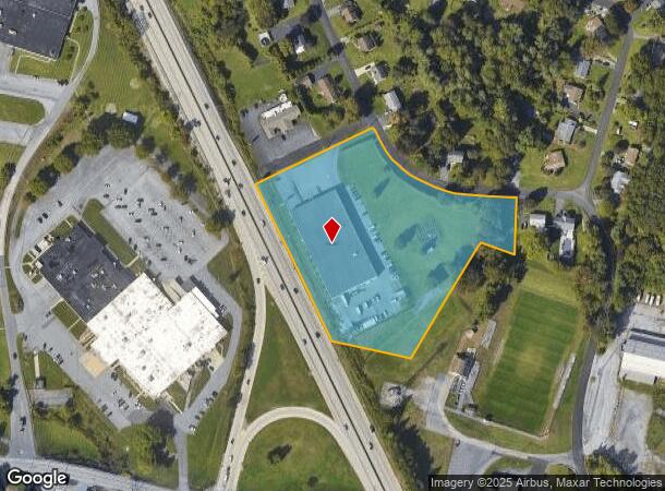
Property Record
2 Laurel Rd, New Cumberland, PA 17070


NEARBY LISTINGS FOR SALE OR LEASE
Property Detail
2 Laurel Rd
27-000-22-0001.A0-00000
Green Hills
Warehouse
York
X
Pennsylvania
42133C0065F
5.19 AC
2025
York County
2025
Philadelphia
020220
York-Hanover, PA
37,520 SF
DEMOGRAPHICS near 2 Laurel Rd
1 Mile
3 Mile
5 Mile
2024 Total Population
3,016
16,162
70,894
2029 Population
3,105
16,638
73,179
Pop Growth 2024-2029
+ 2.95%
+ 2.95%
+ 3.22%
Average Age
43
42
40
2024 Total Households
1,175
6,580
27,751
HH Growth 2024-2029
+ 2.98%
+ 2.98%
+ 3.45%
Median Household Inc
$109,444
$88,826
$77,224
Avg Household Size
2.50
2.40
2.40
2024 Avg HH Vehicles
2.00
2.00
2.00
Median Home Value
$258,883
$230,536
$199,268
Median Year Built
1985
1981
1971
Nearby Places
Map Layers
Map Styles
 Street
 Aerial
- Restaurants
- Banks
- Shops
- Fitness
- Groceries
PUBLIC TRANSPORTATION
COMMUTER RAIL
DRIVE
WALK
Distance
15 min
8.3 mi
AIRPORT
Harrisburg International
DRIVE
WALK
Distance
Harrisburg International
22 min
11.6 mi
Freight Ports
Port Newark Container Terminal
DRIVE
WALK
Distance
Port Newark Container Terminal
125 min
81.9 mi
Nearby Properties
Address
Land Use
TOTAL SIZE
Lot Size
Zoning
Address
Land Use
TOTAL SIZE
Lot Size
Zoning
133.33 AC
AG
Address
Land Use
TOTAL SIZE
Lot Size
Zoning
797,500 SF
88.70 AC
LI
Address
Land Use
TOTAL SIZE
Lot Size
Zoning
705,000 SF
54.01 AC
IND
Address
Land Use
TOTAL SIZE
Lot Size
Zoning
9,840 SF
37.87 AC
AG
Address
Land Use
TOTAL SIZE
Lot Size
Zoning
187,759 SF
85.13 AC
ID
Address
Land Use
TOTAL SIZE
Lot Size
Zoning
274,224 SF
19.90 AC
LI
Address
Land Use
TOTAL SIZE
Lot Size
Zoning
23,632 SF
13.16 AC
LI
Address
Land Use
TOTAL SIZE
Lot Size
Zoning
139,688 SF
44.61 AC
RM
Address
Land Use
TOTAL SIZE
Lot Size
Zoning
150,915 SF
28.04 AC
RCO
Address
Land Use
TOTAL SIZE
Lot Size
Zoning
187,848 SF
21.91 AC
RCO
Address
Land Use
TOTAL SIZE
Lot Size
Zoning
994 SF
12.48 AC
LI
Address
Land Use
TOTAL SIZE
Lot Size
Zoning
43,200 SF
8.13 AC
RCO
Address
Land Use
TOTAL SIZE
Lot Size
Zoning
4,800 SF
54.17 AC
Address
Land Use
TOTAL SIZE
Lot Size
Zoning
128,582 SF
8.37 AC
CH
Address
Land Use
TOTAL SIZE
Lot Size
Zoning
85,500 SF
5.93 AC
LI
Address
Land Use
TOTAL SIZE
Lot Size
Zoning
10,300 SF
11.61 AC
AG
Address
Land Use
TOTAL SIZE
Lot Size
Zoning
5,950 SF
9.23 AC
CN
Address
Land Use
TOTAL SIZE
Lot Size
Zoning
30,622 SF
2.76 AC
RS
Address
Land Use
TOTAL SIZE
Lot Size
Zoning
70,976 SF
4.29 AC
LI
Address
Land Use
TOTAL SIZE
Lot Size
Zoning
6.35 AC
Address
Land Use
TOTAL SIZE
Lot Size
Zoning
77 AC
CN
Address
Land Use
TOTAL SIZE
Lot Size
Zoning
18,258 SF
60.43 AC
Address
Land Use
TOTAL SIZE
Lot Size
Zoning
70,000 SF
5.12 AC
LI
Address
Land Use
TOTAL SIZE
Lot Size
Zoning
60,000 SF
5.63 AC
CH
Address
Land Use
TOTAL SIZE
Lot Size
Zoning
31,500 SF
0.69 AC
Address
Land Use
TOTAL SIZE
Lot Size
Zoning
60,732 SF
6.13 AC
CM
Address
Land Use
TOTAL SIZE
Lot Size
Zoning
Address
Land Use
TOTAL SIZE
Lot Size
Zoning
11.73 AC
Address
Land Use
TOTAL SIZE
Lot Size
Zoning
25,600 SF
4.06 AC
MU
Address
Land Use
TOTAL SIZE
Lot Size
Zoning
25,530 SF
0.60 AC
The World's #1 Commercial Real Estate Marketplace
Connect with us
© 2026 CoStar Group
The information above has been obtained from sources believed reliable. While we do not doubt its accuracy we have not verified it and make no guarantee, warranty or representation about it. It is your responsibility to independently confirm its accuracy and completeness. Any projections, opinions, assumptions, or estimates used are for example only and do not represent the current or future performance of the property. The value of this transaction to you depends on tax and other factors which should be evaluated by your tax, financial, and legal advisors. You and your advisors should conduct a careful, independent investigation of the property to determine to your satisfaction the suitability of the property for your needs.