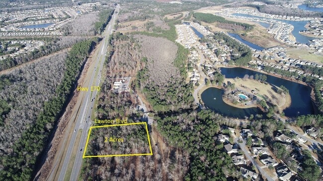
Property Record
2 Lawton Blvd, Bluffton, SC 29910


NEARBY LISTINGS FOR SALE OR LEASE
Property Detail
2 Lawton Blvd
Other Market Areas
Palmetto Pointe Commercial
Hilton Head Island-Bluffton-Beaufort, SC
POR PAR 8A FUTURE DEVELOPMENT OUTPARCEL 1 PB113 P6-12 PB118 P108
R610-028-000-2655-0000
Beaufort
Commercialnec
South Carolina
2025
2 AC
2024
Hilton Head/Beaufort
002103
DEMOGRAPHICS near 2 Lawton Blvd
1 Mile
3 Mile
5 Mile
2024 Total Population
6,182
30,887
52,875
2029 Population
6,889
34,577
60,449
Pop Growth 2024-2029
+ 11.44%
+ 11.95%
+ 14.32%
Average Age
46
49
47
2024 Total Households
2,411
12,657
21,792
HH Growth 2024-2029
+ 10.74%
+ 11.26%
+ 14.22%
Median Household Inc
$90,982
$82,493
$79,845
Avg Household Size
2.50
2.30
2.30
2024 Avg HH Vehicles
2.00
2.00
2.00
Median Home Value
$360,474
$344,547
$357,749
Median Year Built
2009
2006
2007
Nearby Places
Map Layers
Map Styles
 Street
 Aerial
- Restaurants
- Banks
- Shops
- Fitness
- Groceries
PUBLIC TRANSPORTATION
AIRPORT
Hilton Head
DRIVE
WALK
Distance
Hilton Head
32 min
19.6 mi
Savannah/Hilton Head International
DRIVE
WALK
Distance
Savannah/Hilton Head International
40 min
22.2 mi
Freight Ports
Georgia Ports - Savannah
DRIVE
WALK
Distance
Georgia Ports - Savannah
36 min
19.5 mi
SALE & LEASE HISTORY
LISTING DATE
SALE/LEASE

Jan 24, 2023
For Sale
Apr 04, 2017
For Sale
Nearby Properties
Address
Land Use
TOTAL SIZE
Lot Size
Zoning
Address
Land Use
TOTAL SIZE
Lot Size
Zoning
359,002 SF
29.31 AC
6106
Address
Land Use
TOTAL SIZE
Lot Size
Zoning
68,420 SF
6.85 AC
Address
Land Use
TOTAL SIZE
Lot Size
Zoning
188,132 SF
10.59 AC
Address
Land Use
TOTAL SIZE
Lot Size
Zoning
26,844 SF
18.35 AC
6106
Address
Land Use
TOTAL SIZE
Lot Size
Zoning
696 SF
41.71 AC
6116
Address
Land Use
TOTAL SIZE
Lot Size
Zoning
104,364 SF
25 AC
6606
Address
Land Use
TOTAL SIZE
Lot Size
Zoning
119,800 SF
9.37 AC
Address
Land Use
TOTAL SIZE
Lot Size
Zoning
65,544 SF
14.28 AC
6106
Address
Land Use
TOTAL SIZE
Lot Size
Zoning
40,847 SF
3.79 AC
Address
Land Use
TOTAL SIZE
Lot Size
Zoning
81,625 SF
5.43 AC
Address
Land Use
TOTAL SIZE
Lot Size
Zoning
30,305 SF
0.93 AC
Address
Land Use
TOTAL SIZE
Lot Size
Zoning
89,537 SF
12.29 AC
Address
Land Use
TOTAL SIZE
Lot Size
Zoning
65,592 SF
3.33 AC
6606
Address
Land Use
TOTAL SIZE
Lot Size
Zoning
65,544 SF
3.43 AC
Address
Land Use
TOTAL SIZE
Lot Size
Zoning
43,031 SF
5.92 AC
6606
Address
Land Use
TOTAL SIZE
Lot Size
Zoning
53,860 SF
3.49 AC
Address
Land Use
TOTAL SIZE
Lot Size
Zoning
17,304 SF
28.46 AC
6816
Address
Land Use
TOTAL SIZE
Lot Size
Zoning
55,148 SF
3.08 AC
Address
Land Use
TOTAL SIZE
Lot Size
Zoning
21,600 SF
2.37 AC
6616
Address
Land Use
TOTAL SIZE
Lot Size
Zoning
33,348 SF
32.24 AC
6616
Address
Land Use
TOTAL SIZE
Lot Size
Zoning
79,672 SF
7.32 AC
Address
Land Use
TOTAL SIZE
Lot Size
Zoning
82,256 SF
2.07 AC
6606
Address
Land Use
TOTAL SIZE
Lot Size
Zoning
86,347 SF
2.61 AC
Address
Land Use
TOTAL SIZE
Lot Size
Zoning
22,293 SF
92.20 AC
6106
Address
Land Use
TOTAL SIZE
Lot Size
Zoning
18,879 SF
1.92 AC
6616
Address
Land Use
TOTAL SIZE
Lot Size
Zoning
26,784 SF
2.67 AC
Address
Land Use
TOTAL SIZE
Lot Size
Zoning
48,862 SF
8.99 AC
6616
Address
Land Use
TOTAL SIZE
Lot Size
Zoning
119,200 SF
7.98 AC
6606
Address
Land Use
TOTAL SIZE
Lot Size
Zoning
46,472 SF
4.78 AC
6616
Address
Land Use
TOTAL SIZE
Lot Size
Zoning
53,670 SF
225.87 AC
9999
The World's #1 Commercial Real Estate Marketplace
Connect with us
© 2025 CoStar Group
The information above has been obtained from sources believed reliable. While we do not doubt its accuracy we have not verified it and make no guarantee, warranty or representation about it. It is your responsibility to independently confirm its accuracy and completeness. Any projections, opinions, assumptions, or estimates used are for example only and do not represent the current or future performance of the property. The value of this transaction to you depends on tax and other factors which should be evaluated by your tax, financial, and legal advisors. You and your advisors should conduct a careful, independent investigation of the property to determine to your satisfaction the suitability of the property for your needs.