Property Record
2 Linseed Rd, West Hatfield, MA 01088

Save to a Folder
{{folder.Name}}
{{folder.ListingIds.length}} Properties
{{folder.ListingIds.length}} Property
Create a New Folder
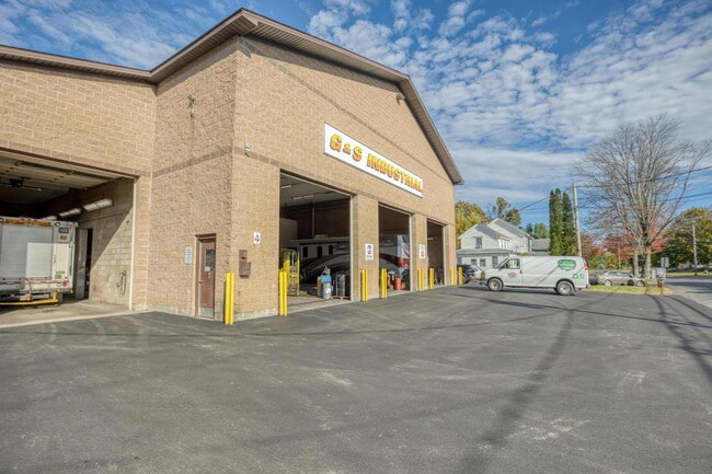
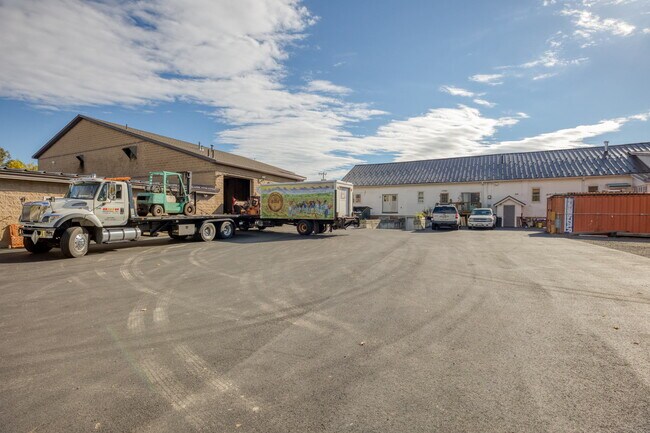
Property Detail
2 Linseed Rd
HATF-000219-000056
Hampshire
Commercialofficeresidentialmixeduse
Massachusetts
B
5.53 AC
2025
Hampshire County
2025
Hartford
821500
Amherst Town-Northampton, MA
33,025 SF
NEARBY LISTINGS FOR SALE OR LEASE
-
-
View all West Hatfield listings for sale on LoopNet.com
DEMOGRAPHICS near 2 Linseed Rd
1 mile
3 mile
5 mile
2025 Total Population
757
11,867
36,668
2030 Population
751
11,768
36,446
Pop Growth 2025-2030
(0.79%)
(0.83%)
(0.61%)
Average Age
50
46
43
2025 Total Households
357
5,423
15,815
HH Growth 2025-2030
(0.56%)
(0.89%)
(0.71%)
Median Household Inc
$100,937
$82,434
$82,885
Avg Household Size
2.00
2.10
2.10
2025 Avg HH Vehicles
2.00
2.00
2.00
Median Home Value
$440,476
$441,268
$444,641
Median Year Built
1967
1958
1956
Nearby Places
Map Layers
Map Styles
 Street
 Aerial
Layers
 Traffic
 Biking
Places
Listings with unknown addresses are not visible on the map
- Restaurants
- Banks
- Shops
- Fitness
- Groceries
PUBLIC TRANSPORTATION
COMMUTER RAIL
Northampton (Valley Flyer - Amtrak, Vermonter - Amtrak)
Drive
Walk
Distance
Northampton (Valley Flyer - Amtrak, Vermonter - Amtrak)
9 min
4.2 mi
Freight Ports
Albany, NY Port
Drive
Walk
Distance
Albany, NY Port
117 min
96.1 mi
SALE & LEASE HISTORY
LISTING DATE
SALE/LEASE

Oct 20, 2021
For Sale
Nearby Properties
Address
Land Use
TOTAL SIZE
Lot Size
Zoning
Address
Land Use
TOTAL SIZE
Lot Size
Zoning
476,724 SF
57.56 AC
I
Address
Land Use
TOTAL SIZE
Lot Size
Zoning
9,424 SF
17.24 AC
AR
Address
Land Use
TOTAL SIZE
Lot Size
Zoning
18.04 AC
URB
Address
Land Use
TOTAL SIZE
Lot Size
Zoning
143,471 SF
22.12 AC
URA
Address
Land Use
TOTAL SIZE
Lot Size
Zoning
26.50 AC
URB
Address
Land Use
TOTAL SIZE
Lot Size
Zoning
12.23 AC
HB
Address
Land Use
TOTAL SIZE
Lot Size
Zoning
30.42 AC
URB
Address
Land Use
TOTAL SIZE
Lot Size
Zoning
7.58 AC
HB
Address
Land Use
TOTAL SIZE
Lot Size
Zoning
10.37 AC
HB
Address
Land Use
TOTAL SIZE
Lot Size
Zoning
21.77 AC
GI
Address
Land Use
TOTAL SIZE
Lot Size
Zoning
359,938 SF
38.84 AC
I
Address
Land Use
TOTAL SIZE
Lot Size
Zoning
59,471 SF
35 AC
LGT
Address
Land Use
TOTAL SIZE
Lot Size
Zoning
4.19 AC
HB
Address
Land Use
TOTAL SIZE
Lot Size
Zoning
42,070 SF
4.38 AC
URA
Address
Land Use
TOTAL SIZE
Lot Size
Zoning
5.36 AC
HB
Address
Land Use
TOTAL SIZE
Lot Size
Zoning
5.06 AC
URC
Address
Land Use
TOTAL SIZE
Lot Size
Zoning
53,344 SF
9.07 AC
TC
Address
Land Use
TOTAL SIZE
Lot Size
Zoning
280,518 SF
60.66 AC
I
Address
Land Use
TOTAL SIZE
Lot Size
Zoning
10.07 AC
URB
Address
Land Use
TOTAL SIZE
Lot Size
Zoning
16.77 AC
SI
Address
Land Use
TOTAL SIZE
Lot Size
Zoning
55,644 SF
5.21 AC
BUS
Address
Land Use
TOTAL SIZE
Lot Size
Zoning
49,757 SF
11.07 AC
SR
Address
Land Use
TOTAL SIZE
Lot Size
Zoning
6,930 SF
2.95 AC
HB
Address
Land Use
TOTAL SIZE
Lot Size
Zoning
23,619 SF
2 AC
HB
Address
Land Use
TOTAL SIZE
Lot Size
Zoning
768 SF
2.13 AC
URB
Address
Land Use
TOTAL SIZE
Lot Size
Zoning
38,194 SF
3.42 AC
HB
Address
Land Use
TOTAL SIZE
Lot Size
Zoning
938 AC
RR
Address
Land Use
TOTAL SIZE
Lot Size
Zoning
2.88 AC
URB
Address
Land Use
TOTAL SIZE
Lot Size
Zoning
32,449 SF
10.45 AC
B
Address
Land Use
TOTAL SIZE
Lot Size
Zoning
3.02 AC
URA
The World's #1 Commercial Real Estate Marketplace
Connect with us
© 2026 CoStar Group
The information above has been obtained from sources believed reliable. While we do not doubt its accuracy we have not verified it and make no guarantee, warranty or representation about it. It is your responsibility to independently confirm its accuracy and completeness. Any projections, opinions, assumptions, or estimates used are for example only and do not represent the current or future performance of the property. The value of this transaction to you depends on tax and other factors which should be evaluated by your tax, financial, and legal advisors. You and your advisors should conduct a careful, independent investigation of the property to determine to your satisfaction the suitability of the property for your needs.