Property Record
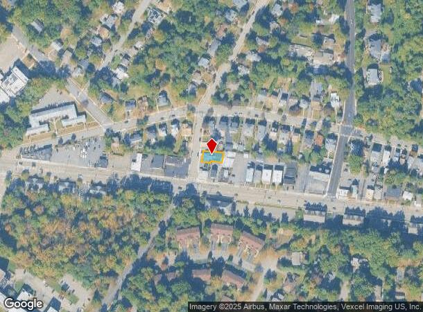
2 Linwood Ter, Caldwell, NJ 07006

NEARBY LISTINGS FOR SALE OR LEASE
Property Detail
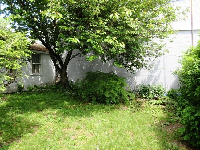
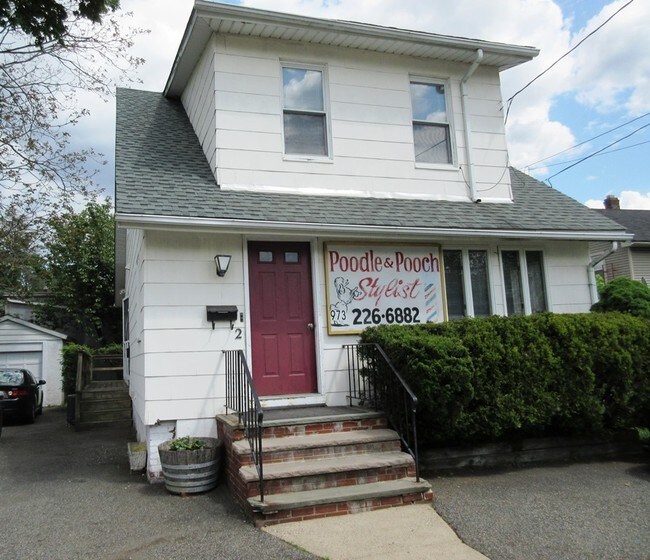
2 Linwood Ter
03-00008-0000-00012
50X88 IRR
Retailwithmorethanonenonretailuse
Essex
X
New Jersey
34013C0084F
12
2023
0.10 AC
2025
Suburban Essex/Rt 280
021701
Northern New Jersey
1,509 SF
Newark, NJ-PA
DEMOGRAPHICS near 2 Linwood Ter
1 Mile
3 Mile
5 Mile
2024 Total Population
16,110
90,819
291,907
2029 Population
15,983
90,208
288,418
Pop Growth 2024-2029
(0.79%)
(0.67%)
(1.20%)
Average Age
41
43
41
2024 Total Households
5,942
34,271
107,884
HH Growth 2024-2029
(0.99%)
(0.90%)
(1.35%)
Median Household Inc
$124,646
$138,305
$115,069
Avg Household Size
2.50
2.60
2.60
2024 Avg HH Vehicles
2.00
2.00
2.00
Median Home Value
$651,863
$605,192
$570,792
Median Year Built
1955
1958
1957
Nearby Places
Map Layers
Map Styles
 Street
 Aerial
- Restaurants
- Banks
- Shops
- Fitness
- Groceries
PUBLIC TRANSPORTATION
COMMUTER RAIL
Watchung Avenue (Montclair-Boonton Line - NJ Transit Commuter Rail (NJ Transit))
DRIVE
WALK
Distance
Watchung Avenue (Montclair-Boonton Line - NJ Transit Commuter Rail (NJ Transit))
8 min
4.1 mi
Upper Montclair (Montclair-Boonton Line - NJ Transit Commuter Rail (NJ Transit))
DRIVE
WALK
Distance
Upper Montclair (Montclair-Boonton Line - NJ Transit Commuter Rail (NJ Transit))
9 min
4.3 mi
AIRPORT
Newark Liberty International
DRIVE
WALK
Distance
Newark Liberty International
25 min
14.7 mi
LaGuardia
DRIVE
WALK
Distance
LaGuardia
48 min
33.1 mi
John F Kennedy International
DRIVE
WALK
Distance
John F Kennedy International
58 min
36.1 mi
Freight Ports
Port Newark Container Terminal
DRIVE
WALK
Distance
Port Newark Container Terminal
28 min
14.6 mi
SALE & LEASE HISTORY
LISTING DATE
SALE/LEASE

Sep 24, 2016
For Sale
Nearby Properties
Address
Land Use
TOTAL SIZE
Lot Size
Zoning
Address
Land Use
TOTAL SIZE
Lot Size
Zoning
33.60 AC
P-C
Address
Land Use
TOTAL SIZE
Lot Size
Zoning
74.58 AC
S
Address
Land Use
TOTAL SIZE
Lot Size
Zoning
48.85 AC
R-3B
Address
Land Use
TOTAL SIZE
Lot Size
Zoning
31.36 AC
P-6
Address
Land Use
TOTAL SIZE
Lot Size
Zoning
101.44 AC
OB-1
Address
Land Use
TOTAL SIZE
Lot Size
Zoning
32.34 AC
RA
Address
Land Use
TOTAL SIZE
Lot Size
Zoning
55.77 AC
OB-1
Address
Land Use
TOTAL SIZE
Lot Size
Zoning
4.60 AC
Address
Land Use
TOTAL SIZE
Lot Size
Zoning
51.24 AC
OB-2
Address
Land Use
TOTAL SIZE
Lot Size
Zoning
84.70 AC
Address
Land Use
TOTAL SIZE
Lot Size
Zoning
17.90 AC
B-2
Address
Land Use
TOTAL SIZE
Lot Size
Zoning
8.79 AC
R-1
Address
Land Use
TOTAL SIZE
Lot Size
Zoning
364.34 AC
R-1
Address
Land Use
TOTAL SIZE
Lot Size
Zoning
25.88 AC
Address
Land Use
TOTAL SIZE
Lot Size
Zoning
41.84 AC
OB-1
Address
Land Use
TOTAL SIZE
Lot Size
Zoning
67.49 AC
Address
Land Use
TOTAL SIZE
Lot Size
Zoning
61.69 AC
Address
Land Use
TOTAL SIZE
Lot Size
Zoning
1,760 SF
189.03 AC
R-2
Address
Land Use
TOTAL SIZE
Lot Size
Zoning
27.50 AC
M-2
Address
Land Use
TOTAL SIZE
Lot Size
Zoning
6.01 AC
OB-2
Address
Land Use
TOTAL SIZE
Lot Size
Zoning
5.74 AC
B-2
Address
Land Use
TOTAL SIZE
Lot Size
Zoning
79,668 SF
3.42 AC
0-R
Address
Land Use
TOTAL SIZE
Lot Size
Zoning
31.56 AC
R-3
Address
Land Use
TOTAL SIZE
Lot Size
Zoning
38.40 AC
Address
Land Use
TOTAL SIZE
Lot Size
Zoning
28.06 AC
OB-3
Address
Land Use
TOTAL SIZE
Lot Size
Zoning
7,507 SF
18.82 AC
L-1
Address
Land Use
TOTAL SIZE
Lot Size
Zoning
4.08 AC
Address
Land Use
TOTAL SIZE
Lot Size
Zoning
16.44 AC
OB-1
Address
Land Use
TOTAL SIZE
Lot Size
Zoning
32.99 AC
R-4
Address
Land Use
TOTAL SIZE
Lot Size
Zoning
3.69 AC
P-C
The World's #1 Commercial Real Estate Marketplace
Connect with us
© 2025 CoStar Group
The information above has been obtained from sources believed reliable. While we do not doubt its accuracy we have not verified it and make no guarantee, warranty or representation about it. It is your responsibility to independently confirm its accuracy and completeness. Any projections, opinions, assumptions, or estimates used are for example only and do not represent the current or future performance of the property. The value of this transaction to you depends on tax and other factors which should be evaluated by your tax, financial, and legal advisors. You and your advisors should conduct a careful, independent investigation of the property to determine to your satisfaction the suitability of the property for your needs.