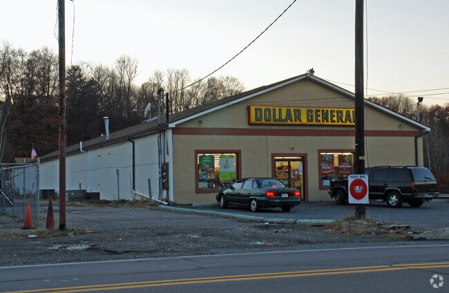
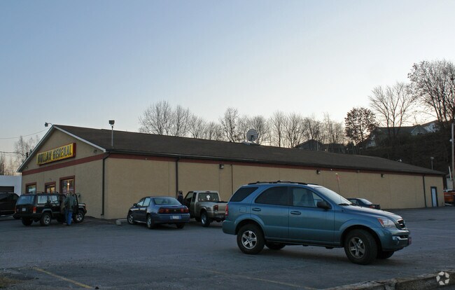
Property Record
2 Lonesome Rd, Old Forge, PA 18518

NEARBY LISTINGS FOR SALE OR LEASE
Property Detail
2 Lonesome Rd
1841104002501
125X220 BLDG & LAND DOLLAR GENERAL
Taxexempt
Lackawanna
AE
Pennsylvania
42069C0301D
0.63 AC
2025
I-81 Corridor
2025
Philadelphia
112700
Scranton--Wilkes-Barre--Hazelton, PA
DEMOGRAPHICS near 2 Lonesome Rd
1 Mile
3 Mile
5 Mile
2024 Total Population
7,160
32,276
76,771
2029 Population
7,059
31,927
76,318
Pop Growth 2024-2029
(1.41%)
(1.08%)
(0.59%)
Average Age
44
44
42
2024 Total Households
3,248
14,141
33,174
HH Growth 2024-2029
(1.39%)
(1.05%)
(0.59%)
Median Household Inc
$64,546
$68,676
$60,923
Avg Household Size
2.20
2.20
2.30
2024 Avg HH Vehicles
2.00
2.00
2.00
Median Home Value
$143,260
$154,642
$146,290
Median Year Built
1951
1955
1950
Nearby Places
Map Layers
Map Styles
 Street
 Aerial
- Restaurants
- Banks
- Shops
- Fitness
- Groceries
PUBLIC TRANSPORTATION
AIRPORT
Wilkes-Barre/Scranton International
DRIVE
WALK
Distance
Wilkes-Barre/Scranton International
9 min
3.9 mi
Freight Ports
Maher Terminal
DRIVE
WALK
Distance
Maher Terminal
151 min
120.6 mi
Nearby Properties
Address
Land Use
TOTAL SIZE
Lot Size
Zoning
Address
Land Use
TOTAL SIZE
Lot Size
Zoning
100 AC
Address
Land Use
TOTAL SIZE
Lot Size
Zoning
Address
Land Use
TOTAL SIZE
Lot Size
Zoning
24.33 AC
Address
Land Use
TOTAL SIZE
Lot Size
Zoning
15.60 AC
Address
Land Use
TOTAL SIZE
Lot Size
Zoning
27.12 AC
Address
Land Use
TOTAL SIZE
Lot Size
Zoning
5.93 AC
Address
Land Use
TOTAL SIZE
Lot Size
Zoning
4.56 AC
Address
Land Use
TOTAL SIZE
Lot Size
Zoning
9.70 AC
Address
Land Use
TOTAL SIZE
Lot Size
Zoning
Address
Land Use
TOTAL SIZE
Lot Size
Zoning
21.70 AC
Address
Land Use
TOTAL SIZE
Lot Size
Zoning
7.67 AC
Address
Land Use
TOTAL SIZE
Lot Size
Zoning
17.05 AC
Address
Land Use
TOTAL SIZE
Lot Size
Zoning
33.16 AC
Address
Land Use
TOTAL SIZE
Lot Size
Zoning
18.18 AC
Address
Land Use
TOTAL SIZE
Lot Size
Zoning
50 AC
Address
Land Use
TOTAL SIZE
Lot Size
Zoning
Address
Land Use
TOTAL SIZE
Lot Size
Zoning
20.40 AC
Address
Land Use
TOTAL SIZE
Lot Size
Zoning
1.97 AC
Address
Land Use
TOTAL SIZE
Lot Size
Zoning
3.82 AC
Address
Land Use
TOTAL SIZE
Lot Size
Zoning
20 AC
Address
Land Use
TOTAL SIZE
Lot Size
Zoning
7.05 AC
Address
Land Use
TOTAL SIZE
Lot Size
Zoning
11.03 AC
Address
Land Use
TOTAL SIZE
Lot Size
Zoning
6.89 AC
Address
Land Use
TOTAL SIZE
Lot Size
Zoning
21.98 AC
Address
Land Use
TOTAL SIZE
Lot Size
Zoning
36.41 AC
Address
Land Use
TOTAL SIZE
Lot Size
Zoning
26.80 AC
Address
Land Use
TOTAL SIZE
Lot Size
Zoning
22.35 AC
Address
Land Use
TOTAL SIZE
Lot Size
Zoning
12.10 AC
Address
Land Use
TOTAL SIZE
Lot Size
Zoning
0.82 AC
Address
Land Use
TOTAL SIZE
Lot Size
Zoning
4.89 AC
The World's #1 Commercial Real Estate Marketplace
Connect with us
© 2025 CoStar Group
The information above has been obtained from sources believed reliable. While we do not doubt its accuracy we have not verified it and make no guarantee, warranty or representation about it. It is your responsibility to independently confirm its accuracy and completeness. Any projections, opinions, assumptions, or estimates used are for example only and do not represent the current or future performance of the property. The value of this transaction to you depends on tax and other factors which should be evaluated by your tax, financial, and legal advisors. You and your advisors should conduct a careful, independent investigation of the property to determine to your satisfaction the suitability of the property for your needs.