Property Record
2 Lsp Dr, Union, SC 29379
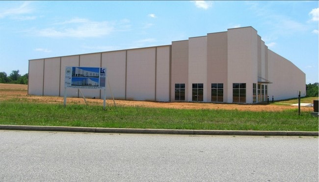


Property Detail
2 Lsp Dr
055-00-00-236 000
UNION
Industrialacreage
South Carolina
B and X Area of moderate flood hazard, usually the area between the limits of the 100-year and 500-year floods.
20 AC
0
Union County
2025
Other Market Areas
030401
Spartanburg, SC
NEARBY LISTINGS FOR SALE OR LEASE
-
-
View all Union listings for sale on LoopNet.com
DEMOGRAPHICS near 2 Lsp Dr
1 mile
3 mile
5 mile
2025 Total Population
299
6,555
15,996
2030 Population
298
6,457
15,902
Pop Growth 2025-2030
(0.33%)
(1.50%)
(0.59%)
Average Age
44
43
42
2025 Total Households
112
2,776
6,809
HH Growth 2025-2030
(0.89%)
(1.59%)
(0.65%)
Median Household Inc
$53,333
$37,620
$36,567
Avg Household Size
2.30
2.30
2.30
2025 Avg HH Vehicles
2.00
2.00
2.00
Median Home Value
$140,384
$100,464
$100,709
Median Year Built
1979
1972
1968
Nearby Places
Map Layers
Map Styles
 Street
 Aerial
Layers
 Traffic
 Biking
Places
Listings with unknown addresses are not visible on the map
- Restaurants
- Banks
- Shops
- Fitness
- Groceries
SALE & LEASE HISTORY
LISTING DATE
SALE/LEASE

Sep 24, 2016
For Sale
Nearby Properties
Address
Land Use
TOTAL SIZE
Lot Size
Zoning
Address
Land Use
TOTAL SIZE
Lot Size
Zoning
35,380 SF
3.64 AC
Address
Land Use
TOTAL SIZE
Lot Size
Zoning
Address
Land Use
TOTAL SIZE
Lot Size
Zoning
Address
Land Use
TOTAL SIZE
Lot Size
Zoning
84,831 SF
9 AC
Address
Land Use
TOTAL SIZE
Lot Size
Zoning
2,030 SF
73 AC
Address
Land Use
TOTAL SIZE
Lot Size
Zoning
19,392 SF
5 AC
Address
Land Use
TOTAL SIZE
Lot Size
Zoning
Address
Land Use
TOTAL SIZE
Lot Size
Zoning
162,609 SF
24 AC
Address
Land Use
TOTAL SIZE
Lot Size
Zoning
Address
Land Use
TOTAL SIZE
Lot Size
Zoning
Address
Land Use
TOTAL SIZE
Lot Size
Zoning
48.02 AC
Address
Land Use
TOTAL SIZE
Lot Size
Zoning
Address
Land Use
TOTAL SIZE
Lot Size
Zoning
9,120 SF
3 AC
Address
Land Use
TOTAL SIZE
Lot Size
Zoning
Address
Land Use
TOTAL SIZE
Lot Size
Zoning
Address
Land Use
TOTAL SIZE
Lot Size
Zoning
Address
Land Use
TOTAL SIZE
Lot Size
Zoning
Address
Land Use
TOTAL SIZE
Lot Size
Zoning
6.97 AC
Address
Land Use
TOTAL SIZE
Lot Size
Zoning
4.54 AC
Address
Land Use
TOTAL SIZE
Lot Size
Zoning
1.44 AC
Address
Land Use
TOTAL SIZE
Lot Size
Zoning
10,125 SF
1.68 AC
Address
Land Use
TOTAL SIZE
Lot Size
Zoning
5.39 AC
Address
Land Use
TOTAL SIZE
Lot Size
Zoning
5.54 AC
Address
Land Use
TOTAL SIZE
Lot Size
Zoning
Address
Land Use
TOTAL SIZE
Lot Size
Zoning
0.67 AC
Address
Land Use
TOTAL SIZE
Lot Size
Zoning
1.44 AC
Address
Land Use
TOTAL SIZE
Lot Size
Zoning
1.07 AC
Address
Land Use
TOTAL SIZE
Lot Size
Zoning
2,280 SF
Address
Land Use
TOTAL SIZE
Lot Size
Zoning
2,140 SF
1.08 AC
The World's #1 Commercial Real Estate Marketplace
Connect with us
© 2026 CoStar Group
The information above has been obtained from sources believed reliable. While we do not doubt its accuracy we have not verified it and make no guarantee, warranty or representation about it. It is your responsibility to independently confirm its accuracy and completeness. Any projections, opinions, assumptions, or estimates used are for example only and do not represent the current or future performance of the property. The value of this transaction to you depends on tax and other factors which should be evaluated by your tax, financial, and legal advisors. You and your advisors should conduct a careful, independent investigation of the property to determine to your satisfaction the suitability of the property for your needs.