Property Record
2 Main St, Cold Spring Harbor, NY 11724
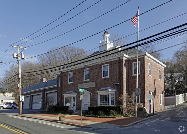

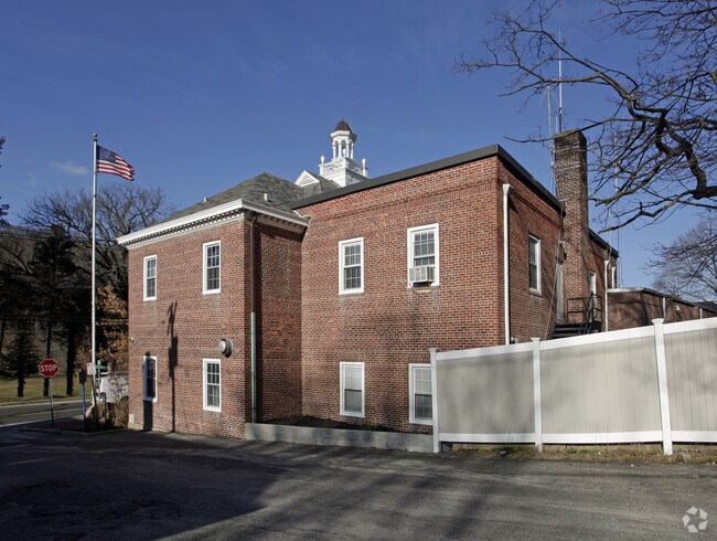
Property Detail
2 Main St
Nassau County-Suffolk County, NY
DESCRIBED
0400-063-00-03-00-020-004
SUFFOLK
Policefirecivildefense
New York
C6
20
B and X Area of moderate flood hazard, usually the area between the limits of the 100-year and 500-year floods.
0.79 AC
0
Western Suffolk
2025
Long Island (New York)
110104
NEARBY LISTINGS FOR SALE OR LEASE
-
-
View all Cold Spring Harbor listings for sale on LoopNet.com
DEMOGRAPHICS near 2 Main St
1 mile
3 mile
5 mile
2025 Total Population
2,381
38,139
124,386
2030 Population
2,391
37,871
123,753
Pop Growth 2025-2030
+ 0.42%
(0.70%)
(0.51%)
Average Age
41
42
43
2025 Total Households
766
13,284
42,089
HH Growth 2025-2030
+ 0.13%
(0.94%)
(0.67%)
Median Household Inc
$223,624
$166,653
$158,539
Avg Household Size
3.00
2.70
2.80
2025 Avg HH Vehicles
2.00
2.00
2.00
Median Home Value
$1,111,524
$854,222
$803,969
Median Year Built
1956
1957
1959
Nearby Places
Map Layers
Map Styles
 Street
 Aerial
Layers
 Traffic
 Biking
Places
Listings with unknown addresses are not visible on the map
- Restaurants
- Banks
- Shops
- Fitness
- Groceries
PUBLIC TRANSPORTATION
COMMUTER RAIL
Cold Spring Harbor Station (Port Jefferson Branch - Long Island Rail Road)
Drive
Walk
Distance
Cold Spring Harbor Station (Port Jefferson Branch - Long Island Rail Road)
5 min
2.7 mi
Huntington Station (Port Jefferson Branch - Long Island Rail Road)
Drive
Walk
Distance
Huntington Station (Port Jefferson Branch - Long Island Rail Road)
8 min
3.6 mi
AIRPORT
Long Island MacArthur
Drive
Walk
Distance
Long Island MacArthur
39 min
22.3 mi
LaGuardia
Drive
Walk
Distance
LaGuardia
43 min
27.8 mi
Westchester County
Drive
Walk
Distance
Westchester County
72 min
46.7 mi
Freight Ports
NY - Red Hook Container Terminal
Drive
Walk
Distance
NY - Red Hook Container Terminal
54 min
35.9 mi
Nearby Properties
Address
Land Use
TOTAL SIZE
Lot Size
Zoning
Address
Land Use
TOTAL SIZE
Lot Size
Zoning
42.21 AC
CA
Address
Land Use
TOTAL SIZE
Lot Size
Zoning
Address
Land Use
TOTAL SIZE
Lot Size
Zoning
Address
Land Use
TOTAL SIZE
Lot Size
Zoning
Address
Land Use
TOTAL SIZE
Lot Size
Zoning
Address
Land Use
TOTAL SIZE
Lot Size
Zoning
Address
Land Use
TOTAL SIZE
Lot Size
Zoning
Address
Land Use
TOTAL SIZE
Lot Size
Zoning
Address
Land Use
TOTAL SIZE
Lot Size
Zoning
Address
Land Use
TOTAL SIZE
Lot Size
Zoning
Address
Land Use
TOTAL SIZE
Lot Size
Zoning
441,456 SF
47.92 AC
Address
Land Use
TOTAL SIZE
Lot Size
Zoning
Address
Land Use
TOTAL SIZE
Lot Size
Zoning
1.50 AC
R40
Address
Land Use
TOTAL SIZE
Lot Size
Zoning
0.06 AC
VILLA
Address
Land Use
TOTAL SIZE
Lot Size
Zoning
11.85 AC
RMS
Address
Land Use
TOTAL SIZE
Lot Size
Zoning
75,253 SF
44.28 AC
Address
Land Use
TOTAL SIZE
Lot Size
Zoning
0.06 AC
VILLA
Address
Land Use
TOTAL SIZE
Lot Size
Zoning
2.60 AC
R80
Address
Land Use
TOTAL SIZE
Lot Size
Zoning
225 AC
R80
Address
Land Use
TOTAL SIZE
Lot Size
Zoning
0.02 AC
VILLA
Address
Land Use
TOTAL SIZE
Lot Size
Zoning
0.23 AC
VILLA
Address
Land Use
TOTAL SIZE
Lot Size
Zoning
0.04 AC
VILLA
Address
Land Use
TOTAL SIZE
Lot Size
Zoning
0.05 AC
VILLA
Address
Land Use
TOTAL SIZE
Lot Size
Zoning
2,555 SF
284.67 AC
Address
Land Use
TOTAL SIZE
Lot Size
Zoning
0.05 AC
VILLA
Address
Land Use
TOTAL SIZE
Lot Size
Zoning
0.05 AC
VILLA
Address
Land Use
TOTAL SIZE
Lot Size
Zoning
0.05 AC
VILLA
Address
Land Use
TOTAL SIZE
Lot Size
Zoning
2,214 SF
0.57 AC
R20
Address
Land Use
TOTAL SIZE
Lot Size
Zoning
0.03 AC
VILLA
Address
Land Use
TOTAL SIZE
Lot Size
Zoning
0.04 AC
VILLA
The World's #1 Commercial Real Estate Marketplace
Connect with us
© 2026 CoStar Group
The information above has been obtained from sources believed reliable. While we do not doubt its accuracy we have not verified it and make no guarantee, warranty or representation about it. It is your responsibility to independently confirm its accuracy and completeness. Any projections, opinions, assumptions, or estimates used are for example only and do not represent the current or future performance of the property. The value of this transaction to you depends on tax and other factors which should be evaluated by your tax, financial, and legal advisors. You and your advisors should conduct a careful, independent investigation of the property to determine to your satisfaction the suitability of the property for your needs.