Property Record
2 Maple St, Hallowell, ME 04347


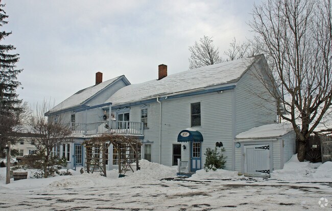
Property Detail
2 Maple St
HALL-000016-000000-000023
Kennebec
Apartment
Maine
35
23
B and X Area of moderate flood hazard, usually the area between the limits of the 100-year and 500-year floods.
1 AC
2025
Maine South & Augusta
2025
Other Market Areas
010700
Augusta-Waterville, ME
2,663 SF
NEARBY LISTINGS FOR SALE OR LEASE
DEMOGRAPHICS near 2 Maple St
1 mile
3 mile
5 mile
2025 Total Population
1,301
13,145
31,967
2030 Population
1,309
13,418
32,593
Pop Growth 2025-2030
+ 0.61%
+ 2.08%
+ 1.96%
Average Age
44
44
44
2025 Total Households
593
5,893
14,455
HH Growth 2025-2030
+ 0.67%
+ 2.09%
+ 2.02%
Median Household Inc
$60,804
$55,645
$55,016
Avg Household Size
2.10
2.10
2.10
2025 Avg HH Vehicles
1.00
1.00
1.00
Median Home Value
$274,399
$221,612
$223,376
Median Year Built
1975
1962
1963
Nearby Places
Map Layers
Map Styles
 Street
 Aerial
Transit
 Traffic
 Biking
Places
Listings with unknown addresses are not visible on the map
- Restaurants
- Banks
- Shops
- Fitness
- Groceries
Nearby Properties
Address
Land Use
TOTAL SIZE
Lot Size
Zoning
Address
Land Use
TOTAL SIZE
Lot Size
Zoning
99,980 SF
11.31 AC
Address
Land Use
TOTAL SIZE
Lot Size
Zoning
35,867 SF
0.04 AC
Address
Land Use
TOTAL SIZE
Lot Size
Zoning
99,295 SF
7.25 AC
Address
Land Use
TOTAL SIZE
Lot Size
Zoning
3.75 AC
Address
Land Use
TOTAL SIZE
Lot Size
Zoning
204,400 SF
7.40 AC
Address
Land Use
TOTAL SIZE
Lot Size
Zoning
20,700 SF
14.46 AC
Address
Land Use
TOTAL SIZE
Lot Size
Zoning
24 AC
33
Address
Land Use
TOTAL SIZE
Lot Size
Zoning
94,766 SF
3.37 AC
Address
Land Use
TOTAL SIZE
Lot Size
Zoning
129,302 SF
37 AC
21
Address
Land Use
TOTAL SIZE
Lot Size
Zoning
66,850 SF
8.92 AC
Address
Land Use
TOTAL SIZE
Lot Size
Zoning
90,421 SF
4.11 AC
Address
Land Use
TOTAL SIZE
Lot Size
Zoning
69,597 SF
9 AC
Address
Land Use
TOTAL SIZE
Lot Size
Zoning
43.02 AC
Address
Land Use
TOTAL SIZE
Lot Size
Zoning
57,527 SF
6.40 AC
Address
Land Use
TOTAL SIZE
Lot Size
Zoning
24,100 SF
7.85 AC
37
Address
Land Use
TOTAL SIZE
Lot Size
Zoning
24,576 SF
3.22 AC
Address
Land Use
TOTAL SIZE
Lot Size
Zoning
21,708 SF
3.35 AC
Address
Land Use
TOTAL SIZE
Lot Size
Zoning
36,792 SF
6 AC
Address
Land Use
TOTAL SIZE
Lot Size
Zoning
32,250 SF
11.77 AC
38
Address
Land Use
TOTAL SIZE
Lot Size
Zoning
0.53 AC
13
Address
Land Use
TOTAL SIZE
Lot Size
Zoning
53,258 SF
2.15 AC
Address
Land Use
TOTAL SIZE
Lot Size
Zoning
3.80 AC
Address
Land Use
TOTAL SIZE
Lot Size
Zoning
45,957 SF
7.80 AC
Address
Land Use
TOTAL SIZE
Lot Size
Zoning
33,411 SF
43 AC
33
Address
Land Use
TOTAL SIZE
Lot Size
Zoning
966 SF
0.83 AC
17
Address
Land Use
TOTAL SIZE
Lot Size
Zoning
30,234 SF
0.79 AC
Address
Land Use
TOTAL SIZE
Lot Size
Zoning
5.28 AC
29
Address
Land Use
TOTAL SIZE
Lot Size
Zoning
23,351 SF
7.60 AC
21
Address
Land Use
TOTAL SIZE
Lot Size
Zoning
39,927 SF
4.84 AC
17
The World's #1 Commercial Real Estate Marketplace
Connect with us
© 2026 CoStar Group
The information above has been obtained from sources believed reliable. While we do not doubt its accuracy we have not verified it and make no guarantee, warranty or representation about it. It is your responsibility to independently confirm its accuracy and completeness. Any projections, opinions, assumptions, or estimates used are for example only and do not represent the current or future performance of the property. The value of this transaction to you depends on tax and other factors which should be evaluated by your tax, financial, and legal advisors. You and your advisors should conduct a careful, independent investigation of the property to determine to your satisfaction the suitability of the property for your needs.