Property Record
2 Marc Rd, Medway, MA 02053
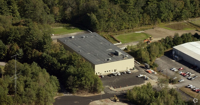

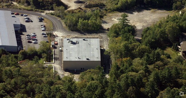
Property Detail
2 Marc Rd
Manufacturinglight
Norfolk
INDI
Massachusetts
AE The base floodplain where base flood elevations are provided. AE Zones are now used on new format FIRMs instead of A1-A30 Zones.
6.93 AC
2025
Hopkinton/Holliston
2025
Boston
408104
Boston-Cambridge-Newton, MA-NH
60,000 SF
MEDW-000033-000000-000001
NEARBY LISTINGS FOR SALE OR LEASE
DEMOGRAPHICS near 2 Marc Rd
1 mile
3 mile
5 mile
2025 Total Population
2,682
30,012
73,646
2030 Population
2,833
31,357
76,557
Pop Growth 2025-2030
+ 5.63%
+ 4.48%
+ 3.95%
Average Age
42
42
42
2025 Total Households
982
10,960
26,160
HH Growth 2025-2030
+ 5.80%
+ 4.57%
+ 4.06%
Median Household Inc
$175,432
$164,855
$168,203
Avg Household Size
2.70
2.70
2.80
2025 Avg HH Vehicles
2.00
2.00
2.00
Median Home Value
$646,584
$677,456
$692,046
Median Year Built
1971
1979
1977
Nearby Places
Map Layers
Map Styles
 Street
 Aerial
Layers
 Traffic
 Biking
Places
Listings with unknown addresses are not visible on the map
- Restaurants
- Banks
- Shops
- Fitness
- Groceries
PUBLIC TRANSPORTATION
COMMUTER RAIL
Norfolk (Franklin Line - Massachusetts Bay Transportation Authority Commuter Rail (Purple Line))
Drive
Walk
Distance
Norfolk (Franklin Line - Massachusetts Bay Transportation Authority Commuter Rail (Purple Line))
11 min
5.8 mi
Franklin (Franklin Line - Massachusetts Bay Transportation Authority Commuter Rail (Purple Line))
Drive
Walk
Distance
Franklin (Franklin Line - Massachusetts Bay Transportation Authority Commuter Rail (Purple Line))
12 min
6.1 mi
AIRPORT
General Edward Lawrence Logan International
Drive
Walk
Distance
General Edward Lawrence Logan International
54 min
31.4 mi
Worcester Regional
Drive
Walk
Distance
Worcester Regional
55 min
34.0 mi
Freight Ports
Port of Boston
Drive
Walk
Distance
Port of Boston
53 min
29.7 mi
Nearby Properties
Address
Land Use
TOTAL SIZE
Lot Size
Zoning
Address
Land Use
TOTAL SIZE
Lot Size
Zoning
146,536 SF
3.30 AC
Address
Land Use
TOTAL SIZE
Lot Size
Zoning
239,156 SF
33.83 AC
AR-I
Address
Land Use
TOTAL SIZE
Lot Size
Zoning
231,643 SF
1.01 AC
AR-I
Address
Land Use
TOTAL SIZE
Lot Size
Zoning
138,644 SF
12.89 AC
Address
Land Use
TOTAL SIZE
Lot Size
Zoning
35.16 AC
ARII
Address
Land Use
TOTAL SIZE
Lot Size
Zoning
11.24 AC
ARII
Address
Land Use
TOTAL SIZE
Lot Size
Zoning
351,209 SF
42.16 AC
I
Address
Land Use
TOTAL SIZE
Lot Size
Zoning
157.50 AC
Address
Land Use
TOTAL SIZE
Lot Size
Zoning
44,772 SF
4.02 AC
I
Address
Land Use
TOTAL SIZE
Lot Size
Zoning
5,509 SF
29.52 AC
AR-I
Address
Land Use
TOTAL SIZE
Lot Size
Zoning
109.15 AC
AR-I
Address
Land Use
TOTAL SIZE
Lot Size
Zoning
1,440 SF
6.97 AC
ARII
Address
Land Use
TOTAL SIZE
Lot Size
Zoning
80,860 SF
8.77 AC
Address
Land Use
TOTAL SIZE
Lot Size
Zoning
68,052 SF
10.34 AC
CB
Address
Land Use
TOTAL SIZE
Lot Size
Zoning
71,001 SF
9.33 AC
Address
Land Use
TOTAL SIZE
Lot Size
Zoning
2,108 SF
3.20 AC
Address
Land Use
TOTAL SIZE
Lot Size
Zoning
43 AC
ARII
Address
Land Use
TOTAL SIZE
Lot Size
Zoning
80,372 SF
16.69 AC
I
Address
Land Use
TOTAL SIZE
Lot Size
Zoning
58,342 SF
2.65 AC
AR-I
Address
Land Use
TOTAL SIZE
Lot Size
Zoning
34,867 SF
3.10 AC
Address
Land Use
TOTAL SIZE
Lot Size
Zoning
11,085 SF
1.40 AC
Address
Land Use
TOTAL SIZE
Lot Size
Zoning
75,416 SF
5.02 AC
INDI
Address
Land Use
TOTAL SIZE
Lot Size
Zoning
91,200 SF
36.71 AC
I
Address
Land Use
TOTAL SIZE
Lot Size
Zoning
54,258 SF
24.15 AC
ARII
Address
Land Use
TOTAL SIZE
Lot Size
Zoning
63,715 SF
6.19 AC
CB
Address
Land Use
TOTAL SIZE
Lot Size
Zoning
4.84 AC
CB
Address
Land Use
TOTAL SIZE
Lot Size
Zoning
288,182 SF
17.60 AC
Address
Land Use
TOTAL SIZE
Lot Size
Zoning
4,646 SF
118 AC
Address
Land Use
TOTAL SIZE
Lot Size
Zoning
13,087 SF
1.10 AC
The World's #1 Commercial Real Estate Marketplace
Connect with us
© 2026 CoStar Group
The information above has been obtained from sources believed reliable. While we do not doubt its accuracy we have not verified it and make no guarantee, warranty or representation about it. It is your responsibility to independently confirm its accuracy and completeness. Any projections, opinions, assumptions, or estimates used are for example only and do not represent the current or future performance of the property. The value of this transaction to you depends on tax and other factors which should be evaluated by your tax, financial, and legal advisors. You and your advisors should conduct a careful, independent investigation of the property to determine to your satisfaction the suitability of the property for your needs.