Property Record
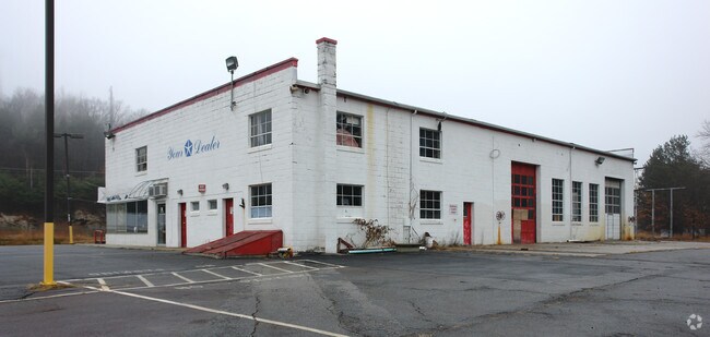
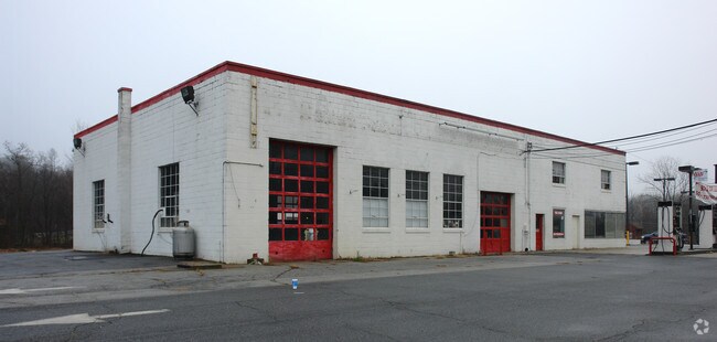
2 Mashapaug Rd, Union, CT 06076

Property Detail
2 Mashapaug Rd
UNIO-000016-000006-000004
TOLLAND
Commercialbuilding
Connecticut
CI
4
2025
4.80 AC
2025
Tolland County
890203
Hartford
11,176 SF
Hartford-West Hartford-East Hartford, CT
NEARBY LISTINGS FOR SALE OR LEASE
-
-
View all Union listings for sale on LoopNet.com
DEMOGRAPHICS near 2 Mashapaug Rd
1 mile
3 mile
5 mile
2025 Total Population
547
2,907
8,110
2030 Population
575
3,035
8,420
Pop Growth 2025-2030
+ 5.12%
+ 4.40%
+ 3.82%
Average Age
47
46
46
2025 Total Households
238
1,263
3,388
HH Growth 2025-2030
+ 5.04%
+ 4.43%
+ 3.93%
Median Household Inc
$90,340
$89,944
$96,379
Avg Household Size
2.30
2.30
2.40
2025 Avg HH Vehicles
2.00
2.00
2.00
Median Home Value
$348,039
$354,699
$357,262
Median Year Built
1978
1980
1980
Nearby Places
Map Layers
Map Styles
 Street
 Aerial
Transit
 Traffic
 Biking
Places
Listings with unknown addresses are not visible on the map
- Restaurants
- Banks
- Shops
- Fitness
- Groceries
PUBLIC TRANSPORTATION
AIRPORT
Worcester Regional
Drive
Walk
Distance
Worcester Regional
45 min
28.9 mi
Bradley International
Drive
Walk
Distance
Bradley International
62 min
45.5 mi
Freight Ports
Port of Davisville, RI
Drive
Walk
Distance
Port of Davisville, RI
100 min
64.8 mi
Nearby Properties
Address
Land Use
TOTAL SIZE
Lot Size
Zoning
Address
Land Use
TOTAL SIZE
Lot Size
Zoning
30,004 SF
9.57 AC
Address
Land Use
TOTAL SIZE
Lot Size
Zoning
71.49 AC
Address
Land Use
TOTAL SIZE
Lot Size
Zoning
3.38 AC
Address
Land Use
TOTAL SIZE
Lot Size
Zoning
2.83 AC
RR
Address
Land Use
TOTAL SIZE
Lot Size
Zoning
6,320 SF
4.80 AC
Address
Land Use
TOTAL SIZE
Lot Size
Zoning
480 AC
RR
Address
Land Use
TOTAL SIZE
Lot Size
Zoning
183.76 AC
Address
Land Use
TOTAL SIZE
Lot Size
Zoning
160.28 AC
CI
Address
Land Use
TOTAL SIZE
Lot Size
Zoning
100 AC
R1
Address
Land Use
TOTAL SIZE
Lot Size
Zoning
4,552 SF
5.62 AC
CI
Address
Land Use
TOTAL SIZE
Lot Size
Zoning
23.64 AC
Address
Land Use
TOTAL SIZE
Lot Size
Zoning
40.28 AC
Address
Land Use
TOTAL SIZE
Lot Size
Zoning
1.70 AC
RR
Address
Land Use
TOTAL SIZE
Lot Size
Zoning
154.41 AC
Address
Land Use
TOTAL SIZE
Lot Size
Zoning
0.10 AC
Address
Land Use
TOTAL SIZE
Lot Size
Zoning
4.22 AC
Address
Land Use
TOTAL SIZE
Lot Size
Zoning
0.53 AC
Address
Land Use
TOTAL SIZE
Lot Size
Zoning
3,228 SF
0.15 AC
Address
Land Use
TOTAL SIZE
Lot Size
Zoning
5.40 AC
CI
Address
Land Use
TOTAL SIZE
Lot Size
Zoning
249.45 AC
Address
Land Use
TOTAL SIZE
Lot Size
Zoning
4,491 SF
13.81 AC
Address
Land Use
TOTAL SIZE
Lot Size
Zoning
5,723 SF
2.60 AC
RT
Address
Land Use
TOTAL SIZE
Lot Size
Zoning
44.55 AC
Address
Land Use
TOTAL SIZE
Lot Size
Zoning
3,488 SF
0.80 AC
Address
Land Use
TOTAL SIZE
Lot Size
Zoning
1,828 SF
8.20 AC
CI
Address
Land Use
TOTAL SIZE
Lot Size
Zoning
180 AC
R1
Address
Land Use
TOTAL SIZE
Lot Size
Zoning
8.50 AC
CI
Address
Land Use
TOTAL SIZE
Lot Size
Zoning
1,297 SF
0.23 AC
Address
Land Use
TOTAL SIZE
Lot Size
Zoning
1.76 AC
RR
The World's #1 Commercial Real Estate Marketplace
Connect with us
© 2026 CoStar Group
The information above has been obtained from sources believed reliable. While we do not doubt its accuracy we have not verified it and make no guarantee, warranty or representation about it. It is your responsibility to independently confirm its accuracy and completeness. Any projections, opinions, assumptions, or estimates used are for example only and do not represent the current or future performance of the property. The value of this transaction to you depends on tax and other factors which should be evaluated by your tax, financial, and legal advisors. You and your advisors should conduct a careful, independent investigation of the property to determine to your satisfaction the suitability of the property for your needs.