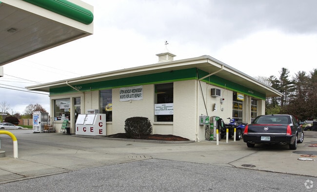
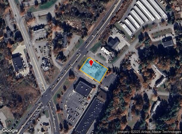
Property Record
2 Mohawk Dr, Londonderry, NH 03053
NEARBY LISTINGS FOR SALE OR LEASE
Property Detail
2 Mohawk Dr
LOND-000006-000000-000041
Rockingham
Servicestation
New Hampshire
X
41-0
33015C0526E
1.27 AC
2024
Rockingham
2024
Boston
003901
Boston-Cambridge-Newton, MA-NH
1,848 SF
DEMOGRAPHICS near 2 Mohawk Dr
1 Mile
3 Mile
5 Mile
2024 Total Population
3,488
26,969
64,249
2029 Population
3,604
27,965
66,496
Pop Growth 2024-2029
+ 3.33%
+ 3.69%
+ 3.50%
Average Age
43
42
41
2024 Total Households
1,410
10,111
24,280
HH Growth 2024-2029
+ 3.12%
+ 3.64%
+ 3.43%
Median Household Inc
$107,184
$111,718
$111,637
Avg Household Size
2.50
2.60
2.60
2024 Avg HH Vehicles
2.00
2.00
2.00
Median Home Value
$412,939
$389,014
$402,713
Median Year Built
1983
1982
1982
Nearby Places
Map Layers
Map Styles
 Street
 Aerial
- Restaurants
- Banks
- Shops
- Fitness
- Groceries
PUBLIC TRANSPORTATION
AIRPORT
Manchester Boston Regional
DRIVE
WALK
Distance
Manchester Boston Regional
22 min
9.5 mi
Freight Ports
Port of Boston
DRIVE
WALK
Distance
Port of Boston
68 min
46.1 mi
Nearby Properties
Address
Land Use
TOTAL SIZE
Lot Size
Zoning
Address
Land Use
TOTAL SIZE
Lot Size
Zoning
15.44 AC
AR-I
Address
Land Use
TOTAL SIZE
Lot Size
Zoning
214,583 SF
110.37 AC
AR-I
Address
Land Use
TOTAL SIZE
Lot Size
Zoning
186,072 SF
18.64 AC
C-I
Address
Land Use
TOTAL SIZE
Lot Size
Zoning
133,188 SF
1.53 AC
AR-I
Address
Land Use
TOTAL SIZE
Lot Size
Zoning
12.73 AC
C-I
Address
Land Use
TOTAL SIZE
Lot Size
Zoning
30.26 AC
C-I
Address
Land Use
TOTAL SIZE
Lot Size
Zoning
31.14 AC
AR-I
Address
Land Use
TOTAL SIZE
Lot Size
Zoning
195,610 SF
20.49 AC
C-I
Address
Land Use
TOTAL SIZE
Lot Size
Zoning
22.09 AC
AR-I
Address
Land Use
TOTAL SIZE
Lot Size
Zoning
90,406 SF
24.78 AC
AR-I
Address
Land Use
TOTAL SIZE
Lot Size
Zoning
108,248 SF
5.92 AC
OMB
Address
Land Use
TOTAL SIZE
Lot Size
Zoning
80,710 SF
20 AC
AR-I
Address
Land Use
TOTAL SIZE
Lot Size
Zoning
41,989 SF
C-III
Address
Land Use
TOTAL SIZE
Lot Size
Zoning
42,956 SF
2.31 AC
Address
Land Use
TOTAL SIZE
Lot Size
Zoning
60,572 SF
5.65 AC
C-I
Address
Land Use
TOTAL SIZE
Lot Size
Zoning
11.28 AC
C-I
Address
Land Use
TOTAL SIZE
Lot Size
Zoning
16.50 AC
C-II
Address
Land Use
TOTAL SIZE
Lot Size
Zoning
34,442 SF
99.29 AC
AR-I
Address
Land Use
TOTAL SIZE
Lot Size
Zoning
59,544 SF
20.23 AC
C-II
Address
Land Use
TOTAL SIZE
Lot Size
Zoning
32.45 AC
C-II
Address
Land Use
TOTAL SIZE
Lot Size
Zoning
15,000 SF
C-III
Address
Land Use
TOTAL SIZE
Lot Size
Zoning
3,720 SF
14.65 AC
C-I
Address
Land Use
TOTAL SIZE
Lot Size
Zoning
145 AC
IND1
Address
Land Use
TOTAL SIZE
Lot Size
Zoning
45,330 SF
1 AC
R3
Address
Land Use
TOTAL SIZE
Lot Size
Zoning
37,931 SF
1.31 AC
CBD
Address
Land Use
TOTAL SIZE
Lot Size
Zoning
9.67 AC
C-I
Address
Land Use
TOTAL SIZE
Lot Size
Zoning
44,280 SF
1 AC
R3
Address
Land Use
TOTAL SIZE
Lot Size
Zoning
25,083 SF
1.42 AC
C-III
Address
Land Use
TOTAL SIZE
Lot Size
Zoning
20,986 SF
2.41 AC
C-III
Address
Land Use
TOTAL SIZE
Lot Size
Zoning
2,320 SF
13 AC
C-I
The World's #1 Commercial Real Estate Marketplace
Connect with us
© 2026 CoStar Group
The information above has been obtained from sources believed reliable. While we do not doubt its accuracy we have not verified it and make no guarantee, warranty or representation about it. It is your responsibility to independently confirm its accuracy and completeness. Any projections, opinions, assumptions, or estimates used are for example only and do not represent the current or future performance of the property. The value of this transaction to you depends on tax and other factors which should be evaluated by your tax, financial, and legal advisors. You and your advisors should conduct a careful, independent investigation of the property to determine to your satisfaction the suitability of the property for your needs.