Property Record
2 N Bank St, Kingman, AZ 86409
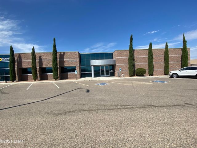
Property Detail
2 N Bank St
Lake Havasu City-Kingman, AZ
MOHAVE
320-04-011C
Arizona
Officebuilding
0.84 AC
C and X Area of minimal flood hazard, usually depicted on FIRMs as above the 500-year flood level.
Prescott & Sedona
6,686 SF
Other Market Areas
NEARBY LISTINGS FOR SALE OR LEASE
DEMOGRAPHICS near 2 N Bank St
1 mile
3 mile
5 mile
2025 Total Population
4,357
39,045
50,326
2030 Population
4,477
40,164
51,896
Pop Growth 2025-2030
+ 2.75%
+ 2.87%
+ 3.12%
Average Age
44
44
45
2025 Total Households
1,740
15,827
20,388
HH Growth 2025-2030
+ 2.76%
+ 2.87%
+ 3.11%
Median Household Inc
$59,152
$51,657
$55,837
Avg Household Size
2.50
2.40
2.40
2025 Avg HH Vehicles
2.00
2.00
2.00
Median Home Value
$227,149
$197,729
$226,708
Median Year Built
1995
1992
1993
Nearby Places
Map Layers
Map Styles
 Street
 Aerial
Layers
 Traffic
 Biking
Places
Listings with unknown addresses are not visible on the map
- Restaurants
- Banks
- Shops
- Fitness
- Groceries
PUBLIC TRANSPORTATION
AIRPORT
Laughlin/Bullhead International
Drive
Walk
Distance
Laughlin/Bullhead International
58 min
39.7 mi
SALE & LEASE HISTORY
LISTING DATE
SALE/LEASE

Aug 31, 2021
For Sale
Nearby Properties
Address
Land Use
TOTAL SIZE
Lot Size
Zoning
Address
Land Use
TOTAL SIZE
Lot Size
Zoning
1,005,590 SF
26.14 AC
Address
Land Use
TOTAL SIZE
Lot Size
Zoning
180,008 SF
16.14 AC
Address
Land Use
TOTAL SIZE
Lot Size
Zoning
135,163 SF
46.88 AC
Address
Land Use
TOTAL SIZE
Lot Size
Zoning
225,678 SF
60.23 AC
Address
Land Use
TOTAL SIZE
Lot Size
Zoning
644,364 SF
21.56 AC
Address
Land Use
TOTAL SIZE
Lot Size
Zoning
94,623 SF
4.79 AC
Address
Land Use
TOTAL SIZE
Lot Size
Zoning
141,529 SF
33.48 AC
Address
Land Use
TOTAL SIZE
Lot Size
Zoning
117,905 SF
9.83 AC
Address
Land Use
TOTAL SIZE
Lot Size
Zoning
55,166 SF
2.34 AC
Address
Land Use
TOTAL SIZE
Lot Size
Zoning
1,047,133 SF
40 AC
Address
Land Use
TOTAL SIZE
Lot Size
Zoning
34,658 SF
10.73 AC
Address
Land Use
TOTAL SIZE
Lot Size
Zoning
48,720 SF
2.24 AC
Address
Land Use
TOTAL SIZE
Lot Size
Zoning
59,688 SF
2.24 AC
Address
Land Use
TOTAL SIZE
Lot Size
Zoning
40,837 SF
4.55 AC
Address
Land Use
TOTAL SIZE
Lot Size
Zoning
97,756 SF
9.98 AC
Address
Land Use
TOTAL SIZE
Lot Size
Zoning
60,000 SF
3.90 AC
Address
Land Use
TOTAL SIZE
Lot Size
Zoning
41,167 SF
8.42 AC
Address
Land Use
TOTAL SIZE
Lot Size
Zoning
80,602 SF
6.57 AC
Address
Land Use
TOTAL SIZE
Lot Size
Zoning
65,458 SF
1.82 AC
Address
Land Use
TOTAL SIZE
Lot Size
Zoning
104,032 SF
11.47 AC
Address
Land Use
TOTAL SIZE
Lot Size
Zoning
44,253 SF
4.76 AC
Address
Land Use
TOTAL SIZE
Lot Size
Zoning
22,994 SF
9.76 AC
Address
Land Use
TOTAL SIZE
Lot Size
Zoning
109,899 SF
10.83 AC
Address
Land Use
TOTAL SIZE
Lot Size
Zoning
36,554 SF
3.45 AC
Address
Land Use
TOTAL SIZE
Lot Size
Zoning
46,449 SF
1.47 AC
Address
Land Use
TOTAL SIZE
Lot Size
Zoning
69,452 SF
6.63 AC
Address
Land Use
TOTAL SIZE
Lot Size
Zoning
34,109 SF
3.73 AC
Address
Land Use
TOTAL SIZE
Lot Size
Zoning
31,550 SF
6.06 AC
Address
Land Use
TOTAL SIZE
Lot Size
Zoning
49,436 SF
4.35 AC
Address
Land Use
TOTAL SIZE
Lot Size
Zoning
68,154 SF
29 AC
The World's #1 Commercial Real Estate Marketplace
Connect with us
© 2026 CoStar Group
The information above has been obtained from sources believed reliable. While we do not doubt its accuracy we have not verified it and make no guarantee, warranty or representation about it. It is your responsibility to independently confirm its accuracy and completeness. Any projections, opinions, assumptions, or estimates used are for example only and do not represent the current or future performance of the property. The value of this transaction to you depends on tax and other factors which should be evaluated by your tax, financial, and legal advisors. You and your advisors should conduct a careful, independent investigation of the property to determine to your satisfaction the suitability of the property for your needs.