Property Record
2 N State St, Preston, ID 83263
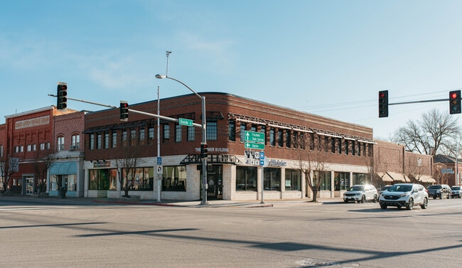

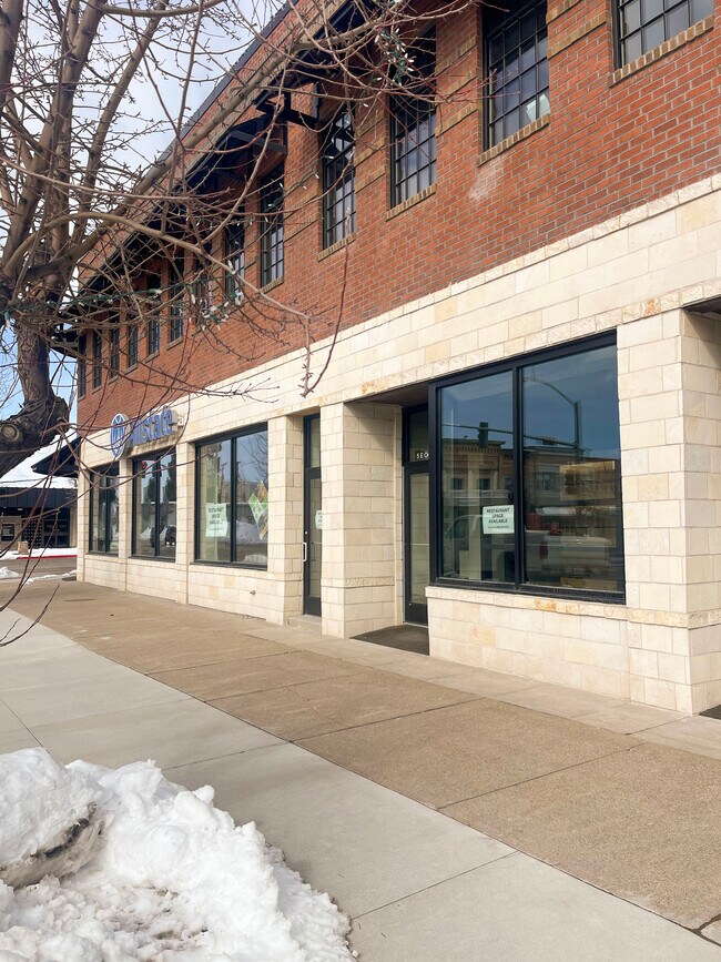
Property Detail
2 N State St
Logan, UT-ID
TN 22; 23-15-39-153; PLAT 40; INST #284059 (OLD BOSEN BLDG)
00005363-00
FRANKLIN
Commercialofficeresidentialmixeduse
Idaho
2025
0.15 AC
2025
Franklin County
970100
Salt Lake City
13,174 SF
NEARBY LISTINGS FOR SALE OR LEASE
-
-
View all Preston listings for lease on LoopNet.com
DEMOGRAPHICS near 2 N State St
1 mile
3 mile
5 mile
2025 Total Population
4,404
7,043
9,163
2030 Population
4,725
7,577
9,874
Pop Growth 2025-2030
+ 7.29%
+ 7.58%
+ 7.76%
Average Age
37
37
37
2025 Total Households
1,510
2,391
3,059
HH Growth 2025-2030
+ 7.42%
+ 7.70%
+ 7.85%
Median Household Inc
$63,214
$65,159
$66,209
Avg Household Size
2.90
2.90
2.90
2025 Avg HH Vehicles
3.00
3.00
3.00
Median Home Value
$359,113
$371,503
$386,135
Median Year Built
1958
1966
1970
Nearby Places
Map Layers
Map Styles
 Street
 Aerial
Layers
 Traffic
 Biking
Places
Listings with unknown addresses are not visible on the map
- Restaurants
- Banks
- Shops
- Fitness
- Groceries
SALE & LEASE HISTORY
LISTING DATE
SALE/LEASE

Sep 08, 2022
For Lease
Mar 02, 2023
For Lease
Nearby Properties
Address
Land Use
TOTAL SIZE
Lot Size
Zoning
Address
Land Use
TOTAL SIZE
Lot Size
Zoning
93,750 SF
19.47 AC
Address
Land Use
TOTAL SIZE
Lot Size
Zoning
2.85 AC
Address
Land Use
TOTAL SIZE
Lot Size
Zoning
14,458 SF
1.81 AC
Address
Land Use
TOTAL SIZE
Lot Size
Zoning
51,120 SF
4.05 AC
Address
Land Use
TOTAL SIZE
Lot Size
Zoning
6,936 SF
3.07 AC
Address
Land Use
TOTAL SIZE
Lot Size
Zoning
49,500 SF
10 AC
Address
Land Use
TOTAL SIZE
Lot Size
Zoning
14,761 SF
8.06 AC
Address
Land Use
TOTAL SIZE
Lot Size
Zoning
42,546 SF
4.86 AC
Address
Land Use
TOTAL SIZE
Lot Size
Zoning
Address
Land Use
TOTAL SIZE
Lot Size
Zoning
10,952 SF
3 AC
Address
Land Use
TOTAL SIZE
Lot Size
Zoning
3,815 SF
0.75 AC
Address
Land Use
TOTAL SIZE
Lot Size
Zoning
10,263 SF
0.35 AC
Address
Land Use
TOTAL SIZE
Lot Size
Zoning
25,375 SF
2 AC
Address
Land Use
TOTAL SIZE
Lot Size
Zoning
25,042 SF
20 AC
Address
Land Use
TOTAL SIZE
Lot Size
Zoning
7,200 SF
5.10 AC
Address
Land Use
TOTAL SIZE
Lot Size
Zoning
34,822 SF
5.03 AC
Address
Land Use
TOTAL SIZE
Lot Size
Zoning
2.21 AC
Address
Land Use
TOTAL SIZE
Lot Size
Zoning
31,470 SF
3 AC
Address
Land Use
TOTAL SIZE
Lot Size
Zoning
5,304 SF
1.50 AC
Address
Land Use
TOTAL SIZE
Lot Size
Zoning
9,600 SF
1.40 AC
Address
Land Use
TOTAL SIZE
Lot Size
Zoning
2,015 SF
0.70 AC
Address
Land Use
TOTAL SIZE
Lot Size
Zoning
6,253 SF
1.59 AC
Address
Land Use
TOTAL SIZE
Lot Size
Zoning
24,343 SF
3.45 AC
Address
Land Use
TOTAL SIZE
Lot Size
Zoning
20,200 SF
9 AC
Address
Land Use
TOTAL SIZE
Lot Size
Zoning
2,250 SF
0.80 AC
Address
Land Use
TOTAL SIZE
Lot Size
Zoning
3,096 SF
1.43 AC
Address
Land Use
TOTAL SIZE
Lot Size
Zoning
19,310 SF
2 AC
Address
Land Use
TOTAL SIZE
Lot Size
Zoning
4.03 AC
The World's #1 Commercial Real Estate Marketplace
Connect with us
© 2026 CoStar Group
The information above has been obtained from sources believed reliable. While we do not doubt its accuracy we have not verified it and make no guarantee, warranty or representation about it. It is your responsibility to independently confirm its accuracy and completeness. Any projections, opinions, assumptions, or estimates used are for example only and do not represent the current or future performance of the property. The value of this transaction to you depends on tax and other factors which should be evaluated by your tax, financial, and legal advisors. You and your advisors should conduct a careful, independent investigation of the property to determine to your satisfaction the suitability of the property for your needs.