Property Record
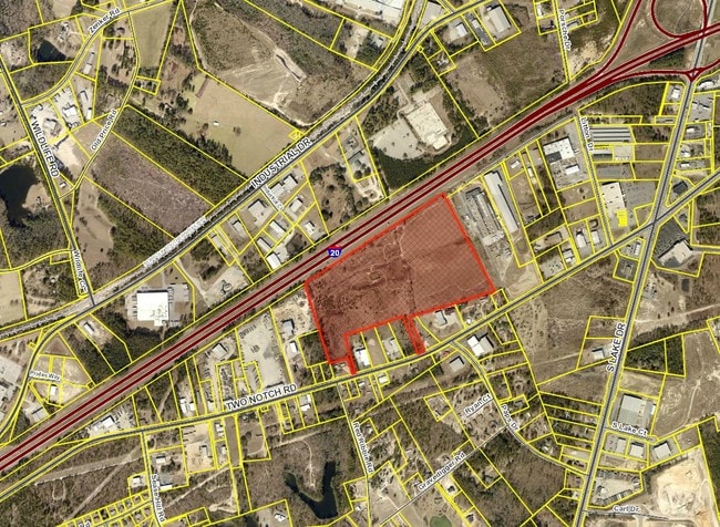
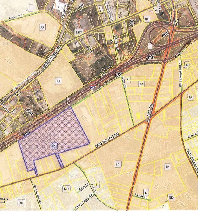
2 Notch Rd, Lexington, SC 29073


Property Detail
2 Notch Rd
005498-07-014
LIES BTWN I-20 & TWO NOTCH RD & OTHER
Publicschool
LEXINGTON
RD
South Carolina
B and X Area of moderate flood hazard, usually the area between the limits of the 100-year and 500-year floods.
46.35 AC
0
Lexington
2024
Columbia
021051
Columbia, SC
832 SF
NEARBY LISTINGS FOR SALE OR LEASE
DEMOGRAPHICS near 2 Notch Rd
1 mile
3 mile
5 mile
2025 Total Population
1,612
30,681
91,332
2030 Population
1,718
32,298
95,717
Pop Growth 2025-2030
+ 6.58%
+ 5.27%
+ 4.80%
Average Age
41
40
39
2025 Total Households
634
11,975
34,392
HH Growth 2025-2030
+ 7.10%
+ 5.48%
+ 4.98%
Median Household Inc
$72,681
$81,739
$90,304
Avg Household Size
2.40
2.50
2.60
2025 Avg HH Vehicles
2.00
2.00
2.00
Median Home Value
$226,354
$247,070
$259,299
Median Year Built
1994
1998
2000
Nearby Places
Map Layers
Map Styles
 Street
 Aerial
Transit
 Traffic
 Biking
Places
Listings with unknown addresses are not visible on the map
- Restaurants
- Banks
- Shops
- Fitness
- Groceries
PUBLIC TRANSPORTATION
AIRPORT
Columbia Metro
Drive
Walk
Distance
Columbia Metro
27 min
8.9 mi
SALE & LEASE HISTORY
LISTING DATE
SALE/LEASE

Sep 24, 2016
For Sale
Jul 06, 2017
For Sale
Nearby Properties
Address
Land Use
TOTAL SIZE
Lot Size
Zoning
Address
Land Use
TOTAL SIZE
Lot Size
Zoning
336,700 SF
80.12 AC
ID
Address
Land Use
TOTAL SIZE
Lot Size
Zoning
78,966 SF
10.34 AC
Address
Land Use
TOTAL SIZE
Lot Size
Zoning
37,794 SF
22.37 AC
ID
Address
Land Use
TOTAL SIZE
Lot Size
Zoning
4,198 SF
23.54 AC
Address
Land Use
TOTAL SIZE
Lot Size
Zoning
3,383 SF
20.65 AC
Address
Land Use
TOTAL SIZE
Lot Size
Zoning
219,967 SF
23.37 AC
ID
Address
Land Use
TOTAL SIZE
Lot Size
Zoning
37,722 SF
6.41 AC
GC
Address
Land Use
TOTAL SIZE
Lot Size
Zoning
3,079 SF
15.93 AC
HDR
Address
Land Use
TOTAL SIZE
Lot Size
Zoning
139,481 SF
15.48 AC
ID
Address
Land Use
TOTAL SIZE
Lot Size
Zoning
9,792 SF
7.47 AC
HDR
Address
Land Use
TOTAL SIZE
Lot Size
Zoning
41,883 SF
21.77 AC
ID
Address
Land Use
TOTAL SIZE
Lot Size
Zoning
835 SF
6.58 AC
ID
Address
Land Use
TOTAL SIZE
Lot Size
Zoning
78,665 SF
7.58 AC
GC
Address
Land Use
TOTAL SIZE
Lot Size
Zoning
15,343 SF
1.30 AC
GC
Address
Land Use
TOTAL SIZE
Lot Size
Zoning
55,686 SF
6.42 AC
ID
Address
Land Use
TOTAL SIZE
Lot Size
Zoning
1,572 SF
21.04 AC
GC
Address
Land Use
TOTAL SIZE
Lot Size
Zoning
54,747 SF
5.70 AC
ID
Address
Land Use
TOTAL SIZE
Lot Size
Zoning
60,000 SF
4.77 AC
ID
Address
Land Use
TOTAL SIZE
Lot Size
Zoning
25,650 SF
1.69 AC
Address
Land Use
TOTAL SIZE
Lot Size
Zoning
17,087 SF
2.60 AC
RD
Address
Land Use
TOTAL SIZE
Lot Size
Zoning
43,078 SF
4.50 AC
Address
Land Use
TOTAL SIZE
Lot Size
Zoning
59,201 SF
7.76 AC
GC
Address
Land Use
TOTAL SIZE
Lot Size
Zoning
51,759 SF
10.18 AC
GC
Address
Land Use
TOTAL SIZE
Lot Size
Zoning
79.51 AC
GC
Address
Land Use
TOTAL SIZE
Lot Size
Zoning
1,200 SF
7.16 AC
ID
Address
Land Use
TOTAL SIZE
Lot Size
Zoning
86,573 SF
4.92 AC
Address
Land Use
TOTAL SIZE
Lot Size
Zoning
38,716 SF
2.07 AC
GC
Address
Land Use
TOTAL SIZE
Lot Size
Zoning
44,851 SF
8.93 AC
ID
Address
Land Use
TOTAL SIZE
Lot Size
Zoning
30,555 SF
3.20 AC
GC
Address
Land Use
TOTAL SIZE
Lot Size
Zoning
42,216 SF
2.52 AC
GC
The World's #1 Commercial Real Estate Marketplace
Connect with us
© 2026 CoStar Group
The information above has been obtained from sources believed reliable. While we do not doubt its accuracy we have not verified it and make no guarantee, warranty or representation about it. It is your responsibility to independently confirm its accuracy and completeness. Any projections, opinions, assumptions, or estimates used are for example only and do not represent the current or future performance of the property. The value of this transaction to you depends on tax and other factors which should be evaluated by your tax, financial, and legal advisors. You and your advisors should conduct a careful, independent investigation of the property to determine to your satisfaction the suitability of the property for your needs.