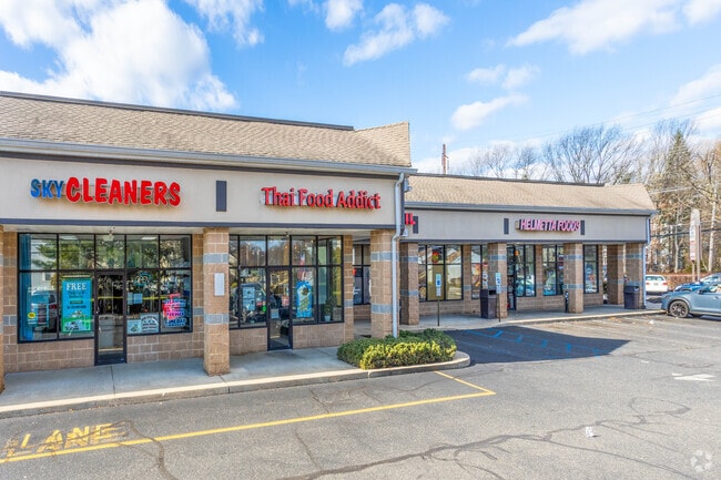
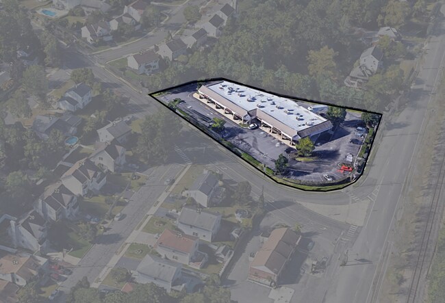
Property Record
Old Forge Rd, Helmetta, NJ 08828

Property Detail
Old Forge Rd
06-00013-0000-00039-03
1.42 AC
Commercialnec
MIDDLESEX
RB
New Jersey
B and X Area of moderate flood hazard, usually the area between the limits of the 100-year and 500-year floods.
39.3
2024
1.42 AC
2025
Brunswick
008103
Northern New Jersey
11,003 SF
Lakewood-New Brunswick, NJ
NEARBY LISTINGS FOR SALE OR LEASE
DEMOGRAPHICS near Old Forge Rd
1 mile
3 mile
5 mile
2025 Total Population
6,791
52,886
138,272
2030 Population
7,110
55,300
144,288
Pop Growth 2025-2030
+ 4.70%
+ 4.56%
+ 4.35%
Average Age
43
42
44
2025 Total Households
2,561
18,393
50,329
HH Growth 2025-2030
+ 4.76%
+ 4.56%
+ 4.36%
Median Household Inc
$119,730
$137,130
$120,404
Avg Household Size
2.60
2.80
2.70
2025 Avg HH Vehicles
2.00
2.00
2.00
Median Home Value
$452,924
$544,259
$527,992
Median Year Built
1985
1978
1978
Nearby Places
Map Layers
Map Styles
 Street
 Aerial
Transit
 Traffic
 Biking
Places
Listings with unknown addresses are not visible on the map
- Restaurants
- Banks
- Shops
- Fitness
- Groceries
PUBLIC TRANSPORTATION
AIRPORT
Trenton Mercer
Drive
Walk
Distance
Trenton Mercer
46 min
28.0 mi
Newark Liberty International
Drive
Walk
Distance
Newark Liberty International
48 min
33.7 mi
Freight Ports
New York Container Terminal
Drive
Walk
Distance
New York Container Terminal
41 min
28.8 mi
SALE & LEASE HISTORY
LISTING DATE
SALE/LEASE

Sep 25, 2016
For Lease
Jul 10, 2025
For Sale
Apr 26, 2017
For Sale
Nearby Properties
Address
Land Use
TOTAL SIZE
Lot Size
Zoning
Address
Land Use
TOTAL SIZE
Lot Size
Zoning
161,447 SF
67.62 AC
R30
Address
Land Use
TOTAL SIZE
Lot Size
Zoning
1,154,372 SF
167.04 AC
LI
Address
Land Use
TOTAL SIZE
Lot Size
Zoning
983,940 SF
62.53 AC
LI
Address
Land Use
TOTAL SIZE
Lot Size
Zoning
Address
Land Use
TOTAL SIZE
Lot Size
Zoning
87.65 AC
LI-4
Address
Land Use
TOTAL SIZE
Lot Size
Zoning
14,552 SF
484.47 AC
R20
Address
Land Use
TOTAL SIZE
Lot Size
Zoning
160,986 SF
60.24 AC
Address
Land Use
TOTAL SIZE
Lot Size
Zoning
29.74 AC
R30
Address
Land Use
TOTAL SIZE
Lot Size
Zoning
5.10 AC
Address
Land Use
TOTAL SIZE
Lot Size
Zoning
18.93 AC
R30
Address
Land Use
TOTAL SIZE
Lot Size
Zoning
44.80 AC
LI-4
Address
Land Use
TOTAL SIZE
Lot Size
Zoning
49.12 AC
LI-4
Address
Land Use
TOTAL SIZE
Lot Size
Zoning
56 AC
LI-4
Address
Land Use
TOTAL SIZE
Lot Size
Zoning
48.39 AC
LI-4
Address
Land Use
TOTAL SIZE
Lot Size
Zoning
299,532 SF
22.35 AC
LI
Address
Land Use
TOTAL SIZE
Lot Size
Zoning
7,701 SF
38.78 AC
R30
Address
Land Use
TOTAL SIZE
Lot Size
Zoning
8,512 SF
65.36 AC
MH
Address
Land Use
TOTAL SIZE
Lot Size
Zoning
413,092 SF
35.48 AC
LI-4
Address
Land Use
TOTAL SIZE
Lot Size
Zoning
227,175 SF
16.43 AC
LI
Address
Land Use
TOTAL SIZE
Lot Size
Zoning
34.73 AC
LI-4
Address
Land Use
TOTAL SIZE
Lot Size
Zoning
36.59 AC
I-3
Address
Land Use
TOTAL SIZE
Lot Size
Zoning
526,400 SF
40 AC
LI-4
Address
Land Use
TOTAL SIZE
Lot Size
Zoning
320,852 SF
39 AC
LI4R
Address
Land Use
TOTAL SIZE
Lot Size
Zoning
26.69 AC
LI-4
Address
Land Use
TOTAL SIZE
Lot Size
Zoning
2.53 AC
HR
Address
Land Use
TOTAL SIZE
Lot Size
Zoning
624 SF
210.30 AC
R30
Address
Land Use
TOTAL SIZE
Lot Size
Zoning
42.08 AC
LI-4
Address
Land Use
TOTAL SIZE
Lot Size
Zoning
91,803 SF
0.65 AC
C-4
Address
Land Use
TOTAL SIZE
Lot Size
Zoning
418,300 SF
27.40 AC
LI-4
Address
Land Use
TOTAL SIZE
Lot Size
Zoning
34.64 AC
LI-4
The World's #1 Commercial Real Estate Marketplace
Connect with us
© 2026 CoStar Group
The information above has been obtained from sources believed reliable. While we do not doubt its accuracy we have not verified it and make no guarantee, warranty or representation about it. It is your responsibility to independently confirm its accuracy and completeness. Any projections, opinions, assumptions, or estimates used are for example only and do not represent the current or future performance of the property. The value of this transaction to you depends on tax and other factors which should be evaluated by your tax, financial, and legal advisors. You and your advisors should conduct a careful, independent investigation of the property to determine to your satisfaction the suitability of the property for your needs.