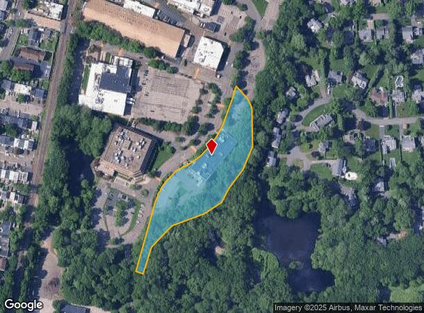
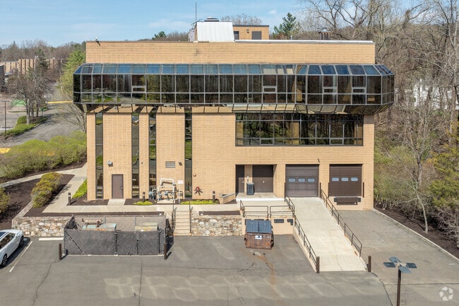
Property Record
2 Omega Dr, Stamford, CT 06907

Current Lease Availabilities
NEARBY LISTINGS FOR SALE OR LEASE
Property Detail
2 Omega Dr
Commercialbuilding
Fairfield
AE
Connecticut
09001C0509F
2.60 AC
2025
Stamford
2025
Westchester/So Connecticut
021000
Bridgeport-Stamford-Norwalk, CT
54,355 SF
STAM-000003-000000-002539
DEMOGRAPHICS near 2 Omega Dr
1 Mile
3 Mile
5 Mile
2024 Total Population
14,899
118,255
219,102
2029 Population
14,979
119,261
220,213
Pop Growth 2024-2029
+ 0.54%
+ 0.85%
+ 0.51%
Average Age
39
39
39
2024 Total Households
5,437
46,385
82,840
HH Growth 2024-2029
+ 0.53%
+ 1.07%
+ 0.67%
Median Household Inc
$119,583
$109,118
$113,376
Avg Household Size
2.70
2.40
2.50
2024 Avg HH Vehicles
2.00
2.00
2.00
Median Home Value
$653,492
$648,522
$737,482
Median Year Built
1963
1969
1969
Nearby Places
- Restaurants
- Banks
- Shops
- Fitness
- Groceries
PUBLIC TRANSPORTATION
COMMUTER RAIL
Springdale Station (New Haven Line - Metro-North Commuter Railroad Company (Metro-North))
DRIVE
WALK
Distance
Springdale Station (New Haven Line - Metro-North Commuter Railroad Company (Metro-North))
2 min
7 min
0.3 mi
Glenbrook Station (New Haven Line - Metro-North Commuter Railroad Company (Metro-North))
DRIVE
WALK
Distance
Glenbrook Station (New Haven Line - Metro-North Commuter Railroad Company (Metro-North))
5 min
1.5 mi
AIRPORT
Westchester County
DRIVE
WALK
Distance
Westchester County
32 min
14.5 mi
LaGuardia
DRIVE
WALK
Distance
LaGuardia
51 min
36.2 mi
John F Kennedy International
DRIVE
WALK
Distance
John F Kennedy International
58 min
43.5 mi
Nearby Properties
Address
Land Use
TOTAL SIZE
Lot Size
Zoning
Address
Land Use
TOTAL SIZE
Lot Size
Zoning
13.21 AC
CSCD
Address
Land Use
TOTAL SIZE
Lot Size
Zoning
8.91 AC
DC
Address
Land Use
TOTAL SIZE
Lot Size
Zoning
336,000 SF
40 AC
MU
Address
Land Use
TOTAL SIZE
Lot Size
Zoning
5.10 AC
MXD
Address
Land Use
TOTAL SIZE
Lot Size
Zoning
Address
Land Use
TOTAL SIZE
Lot Size
Zoning
344,483 SF
CC
Address
Land Use
TOTAL SIZE
Lot Size
Zoning
543,005 SF
2.23 AC
RHD
Address
Land Use
TOTAL SIZE
Lot Size
Zoning
411,596 SF
3.30 AC
MZN
Address
Land Use
TOTAL SIZE
Lot Size
Zoning
4.13 AC
CC
Address
Land Use
TOTAL SIZE
Lot Size
Zoning
358,662 SF
CC
Address
Land Use
TOTAL SIZE
Lot Size
Zoning
46,302 SF
23.50 AC
MG
Address
Land Use
TOTAL SIZE
Lot Size
Zoning
9.62 AC
MZN
Address
Land Use
TOTAL SIZE
Lot Size
Zoning
359,686 SF
1.67 AC
CCN
Address
Land Use
TOTAL SIZE
Lot Size
Zoning
377,754 SF
2.06 AC
PD
Address
Land Use
TOTAL SIZE
Lot Size
Zoning
79.29 AC
P
Address
Land Use
TOTAL SIZE
Lot Size
Zoning
32.68 AC
MD
Address
Land Use
TOTAL SIZE
Lot Size
Zoning
304,617 SF
CI
Address
Land Use
TOTAL SIZE
Lot Size
Zoning
304,345 SF
1.15 AC
PD
Address
Land Use
TOTAL SIZE
Lot Size
Zoning
308,621 SF
CI
Address
Land Use
TOTAL SIZE
Lot Size
Zoning
32.06 AC
DMR
Address
Land Use
TOTAL SIZE
Lot Size
Zoning
235,186 SF
1.29 AC
CG
Address
Land Use
TOTAL SIZE
Lot Size
Zoning
3.14 AC
RH
Address
Land Use
TOTAL SIZE
Lot Size
Zoning
243,000 SF
3.02 AC
CG
Address
Land Use
TOTAL SIZE
Lot Size
Zoning
334,905 SF
2.52 AC
MXD
Address
Land Use
TOTAL SIZE
Lot Size
Zoning
32.43 AC
RA1
Address
Land Use
TOTAL SIZE
Lot Size
Zoning
4.53 AC
RH
Address
Land Use
TOTAL SIZE
Lot Size
Zoning
5.18 AC
CC
Address
Land Use
TOTAL SIZE
Lot Size
Zoning
42.18 AC
P
Address
Land Use
TOTAL SIZE
Lot Size
Zoning
25.91 AC
MZN
Address
Land Use
TOTAL SIZE
Lot Size
Zoning
39,031 SF
451.38 AC
ADD
The World's #1 Commercial Real Estate Marketplace
Connect with us
© 2025 CoStar Group
The information above has been obtained from sources believed reliable. While we do not doubt its accuracy we have not verified it and make no guarantee, warranty or representation about it. It is your responsibility to independently confirm its accuracy and completeness. Any projections, opinions, assumptions, or estimates used are for example only and do not represent the current or future performance of the property. The value of this transaction to you depends on tax and other factors which should be evaluated by your tax, financial, and legal advisors. You and your advisors should conduct a careful, independent investigation of the property to determine to your satisfaction the suitability of the property for your needs.