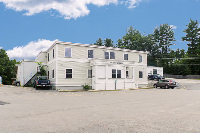
Property Record
2 Omega Way, Littleton, MA 01460
Current Lease Availabilities
NEARBY LISTINGS FOR SALE OR LEASE
Property Detail
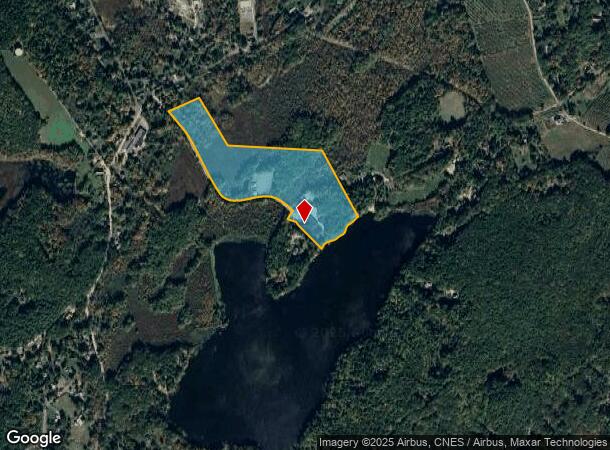
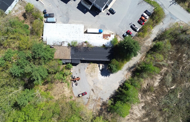
2 Omega Way
LITT-000025U-000004
Middlesex
Industrialgeneral
Massachusetts
A
31.33 AC
25017C0239F
Concord/Maynard
2025
Boston
2025
Boston-Cambridge-Newton, MA-NH
324101
DEMOGRAPHICS near 2 Omega Way
1 Mile
3 Mile
5 Mile
2024 Total Population
769
22,814
57,517
2029 Population
769
22,877
57,372
Pop Growth 2024-2029
0.00%
+ 0.28%
(0.25%)
Average Age
42
42
42
2024 Total Households
273
8,471
21,404
HH Growth 2024-2029
0.00%
+ 0.21%
(0.31%)
Median Household Inc
$151,562
$141,311
$151,075
Avg Household Size
2.70
2.70
2.60
2024 Avg HH Vehicles
2.00
2.00
2.00
Median Home Value
$665,032
$676,399
$689,607
Median Year Built
1990
1979
1979
Nearby Places
Map Layers
Map Styles
 Street
 Aerial
- Restaurants
- Banks
- Shops
- Fitness
- Groceries
PUBLIC TRANSPORTATION
COMMUTER RAIL
Littleton/Route 495 (Fitchburg/South Acton Line - Massachusetts Bay Transportation Authority Commuter Rail (Purple Line))
DRIVE
WALK
Distance
Littleton/Route 495 (Fitchburg/South Acton Line - Massachusetts Bay Transportation Authority Commuter Rail (Purple Line))
8 min
3.0 mi
South Acton (Fitchburg/South Acton Line - Massachusetts Bay Transportation Authority Commuter Rail (Purple Line))
DRIVE
WALK
Distance
South Acton (Fitchburg/South Acton Line - Massachusetts Bay Transportation Authority Commuter Rail (Purple Line))
12 min
5.4 mi
AIRPORT
General Edward Lawrence Logan International
DRIVE
WALK
Distance
General Edward Lawrence Logan International
51 min
30.9 mi
Worcester Regional
DRIVE
WALK
Distance
Worcester Regional
51 min
35.6 mi
Manchester Boston Regional
DRIVE
WALK
Distance
Manchester Boston Regional
59 min
35.9 mi
Freight Ports
Port of Boston
DRIVE
WALK
Distance
Port of Boston
50 min
30.9 mi
Nearby Properties
Address
Land Use
TOTAL SIZE
Lot Size
Zoning
Address
Land Use
TOTAL SIZE
Lot Size
Zoning
197,727 SF
31.55 AC
R2
Address
Land Use
TOTAL SIZE
Lot Size
Zoning
54.50 AC
R
Address
Land Use
TOTAL SIZE
Lot Size
Zoning
143,640 SF
29.44 AC
IA
Address
Land Use
TOTAL SIZE
Lot Size
Zoning
8.39 AC
OP1
Address
Land Use
TOTAL SIZE
Lot Size
Zoning
263,589 SF
8.76 AC
R2
Address
Land Use
TOTAL SIZE
Lot Size
Zoning
39.84 AC
B
Address
Land Use
TOTAL SIZE
Lot Size
Zoning
7.32 AC
R
Address
Land Use
TOTAL SIZE
Lot Size
Zoning
25.15 AC
R2
Address
Land Use
TOTAL SIZE
Lot Size
Zoning
125,160 SF
29.36 AC
R
Address
Land Use
TOTAL SIZE
Lot Size
Zoning
14.47 AC
R108
Address
Land Use
TOTAL SIZE
Lot Size
Zoning
291,926 SF
31.78 AC
IH
Address
Land Use
TOTAL SIZE
Lot Size
Zoning
180,143 SF
41.70 AC
OP
Address
Land Use
TOTAL SIZE
Lot Size
Zoning
20,498 SF
25.75 AC
GI
Address
Land Use
TOTAL SIZE
Lot Size
Zoning
9.96 AC
OP1
Address
Land Use
TOTAL SIZE
Lot Size
Zoning
79,254 SF
18.14 AC
RA
Address
Land Use
TOTAL SIZE
Lot Size
Zoning
131,607 SF
36.01 AC
Address
Land Use
TOTAL SIZE
Lot Size
Zoning
150,515 SF
36.95 AC
OP
Address
Land Use
TOTAL SIZE
Lot Size
Zoning
8.21 AC
R
Address
Land Use
TOTAL SIZE
Lot Size
Zoning
105,036 SF
6.84 AC
KC
Address
Land Use
TOTAL SIZE
Lot Size
Zoning
396,023 SF
23.53 AC
OP1
Address
Land Use
TOTAL SIZE
Lot Size
Zoning
39,250 SF
0.39 AC
R2
Address
Land Use
TOTAL SIZE
Lot Size
Zoning
154,436 SF
18.86 AC
IA
Address
Land Use
TOTAL SIZE
Lot Size
Zoning
55.50 AC
ARC
Address
Land Use
TOTAL SIZE
Lot Size
Zoning
76,623 SF
16.59 AC
R2
Address
Land Use
TOTAL SIZE
Lot Size
Zoning
66,447 SF
11.59 AC
B
Address
Land Use
TOTAL SIZE
Lot Size
Zoning
175,718 SF
20.12 AC
IH
Address
Land Use
TOTAL SIZE
Lot Size
Zoning
65,680 SF
7.59 AC
IA
Address
Land Use
TOTAL SIZE
Lot Size
Zoning
71,395 SF
8.37 AC
C
Address
Land Use
TOTAL SIZE
Lot Size
Zoning
38,552 SF
5.34 AC
LB
Address
Land Use
TOTAL SIZE
Lot Size
Zoning
78,564 SF
3.43 AC
LB
The World's #1 Commercial Real Estate Marketplace
Connect with us
© 2026 CoStar Group
The information above has been obtained from sources believed reliable. While we do not doubt its accuracy we have not verified it and make no guarantee, warranty or representation about it. It is your responsibility to independently confirm its accuracy and completeness. Any projections, opinions, assumptions, or estimates used are for example only and do not represent the current or future performance of the property. The value of this transaction to you depends on tax and other factors which should be evaluated by your tax, financial, and legal advisors. You and your advisors should conduct a careful, independent investigation of the property to determine to your satisfaction the suitability of the property for your needs.