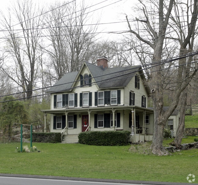
Property Record
2 Pimpewaug Rd, Wilton, CT 06897

Property Detail
2 Pimpewaug Rd
Commercialofficeresidentialmixeduse
Western Ct
R-2
Connecticut
B and X Area of moderate flood hazard, usually the area between the limits of the 100-year and 500-year floods.
4.06 AC
2025
Wilton
2025
Westchester/So Connecticut
045102
Bridgeport-Stamford-Danbury, CT
2,034 SF
WILT-000059-000017
NEARBY LISTINGS FOR SALE OR LEASE
DEMOGRAPHICS near 2 Pimpewaug Rd
1 mile
3 mile
5 mile
2024 Total Population
2,380
20,351
70,411
2029 Population
2,474
20,963
72,355
Pop Growth 2024-2029
+ 3.95%
+ 3.01%
+ 2.76%
Average Age
44
42
43
2024 Total Households
822
6,860
25,280
HH Growth 2024-2029
+ 4.01%
+ 3.02%
+ 2.76%
Median Household Inc
$173,097
$220,721
$194,585
Avg Household Size
2.70
2.90
2.70
2024 Avg HH Vehicles
2.00
2.00
2.00
Median Home Value
$1,006,352
$931,040
$881,722
Median Year Built
1982
1970
1970
Nearby Places
Map Layers
Map Styles
 Street
 Aerial
Transit
 Traffic
 Biking
Places
Listings with unknown addresses are not visible on the map
- Restaurants
- Banks
- Shops
- Fitness
- Groceries
PUBLIC TRANSPORTATION
COMMUTER RAIL
Wilton Station (New Haven Line - Metro-North Commuter Railroad Company (Metro-North))
Drive
Walk
Distance
Wilton Station (New Haven Line - Metro-North Commuter Railroad Company (Metro-North))
1 min
0.5 mi
Cannondale Station (New Haven Line - Metro-North Commuter Railroad Company (Metro-North))
Drive
Walk
Distance
Cannondale Station (New Haven Line - Metro-North Commuter Railroad Company (Metro-North))
2 min
1.3 mi
AIRPORT
Westchester County
Drive
Walk
Distance
Westchester County
37 min
25.6 mi
Tweed/New Haven
Drive
Walk
Distance
Tweed/New Haven
57 min
36.6 mi
Freight Ports
Port of New Haven
Drive
Walk
Distance
Port of New Haven
51 min
34.4 mi
SALE & LEASE HISTORY
LISTING DATE
SALE/LEASE

Oct 11, 2016
For Sale
Nearby Properties
Address
Land Use
TOTAL SIZE
Lot Size
Zoning
Address
Land Use
TOTAL SIZE
Lot Size
Zoning
28.64 AC
DE-10
Address
Land Use
TOTAL SIZE
Lot Size
Zoning
82.14 AC
R-2
Address
Land Use
TOTAL SIZE
Lot Size
Zoning
109.27 AC
R-2
Address
Land Use
TOTAL SIZE
Lot Size
Zoning
196,084 SF
4.34 AC
DE-5
Address
Land Use
TOTAL SIZE
Lot Size
Zoning
260,868 SF
C
Address
Land Use
TOTAL SIZE
Lot Size
Zoning
21.34 AC
B2
Address
Land Use
TOTAL SIZE
Lot Size
Zoning
24.67 AC
DE-10
Address
Land Use
TOTAL SIZE
Lot Size
Zoning
111,713 SF
C
Address
Land Use
TOTAL SIZE
Lot Size
Zoning
12.32 AC
CRA-1
Address
Land Use
TOTAL SIZE
Lot Size
Zoning
34.16 AC
R-2
Address
Land Use
TOTAL SIZE
Lot Size
Zoning
160,264 SF
C
Address
Land Use
TOTAL SIZE
Lot Size
Zoning
10.64 AC
HODD
Address
Land Use
TOTAL SIZE
Lot Size
Zoning
32.55 AC
DE-10
Address
Land Use
TOTAL SIZE
Lot Size
Zoning
33.70 AC
R-2
Address
Land Use
TOTAL SIZE
Lot Size
Zoning
206,490 SF
1 AC
DE-5
Address
Land Use
TOTAL SIZE
Lot Size
Zoning
11.14 AC
B2
Address
Land Use
TOTAL SIZE
Lot Size
Zoning
11 AC
DE-5
Address
Land Use
TOTAL SIZE
Lot Size
Zoning
134.24 AC
A3
Address
Land Use
TOTAL SIZE
Lot Size
Zoning
7.61 AC
WC
Address
Land Use
TOTAL SIZE
Lot Size
Zoning
8.92 AC
R-2
Address
Land Use
TOTAL SIZE
Lot Size
Zoning
77,212 SF
DE-5
Address
Land Use
TOTAL SIZE
Lot Size
Zoning
7.10 AC
DRB
Address
Land Use
TOTAL SIZE
Lot Size
Zoning
75,656 SF
3.81 AC
R-1
Address
Land Use
TOTAL SIZE
Lot Size
Zoning
10.84 AC
DE-5
Address
Land Use
TOTAL SIZE
Lot Size
Zoning
131,476 SF
12.73 AC
DE-5
Address
Land Use
TOTAL SIZE
Lot Size
Zoning
117,972 SF
6.76 AC
WC
Address
Land Use
TOTAL SIZE
Lot Size
Zoning
11.17 AC
R-2
Address
Land Use
TOTAL SIZE
Lot Size
Zoning
127,706 SF
17.68 AC
DE-5
Address
Land Use
TOTAL SIZE
Lot Size
Zoning
130.09 AC
C
Address
Land Use
TOTAL SIZE
Lot Size
Zoning
5.44 AC
The World's #1 Commercial Real Estate Marketplace
Connect with us
© 2026 CoStar Group
The information above has been obtained from sources believed reliable. While we do not doubt its accuracy we have not verified it and make no guarantee, warranty or representation about it. It is your responsibility to independently confirm its accuracy and completeness. Any projections, opinions, assumptions, or estimates used are for example only and do not represent the current or future performance of the property. The value of this transaction to you depends on tax and other factors which should be evaluated by your tax, financial, and legal advisors. You and your advisors should conduct a careful, independent investigation of the property to determine to your satisfaction the suitability of the property for your needs.