Property Record
2 Quincy Rd, Rumney, NH 03266
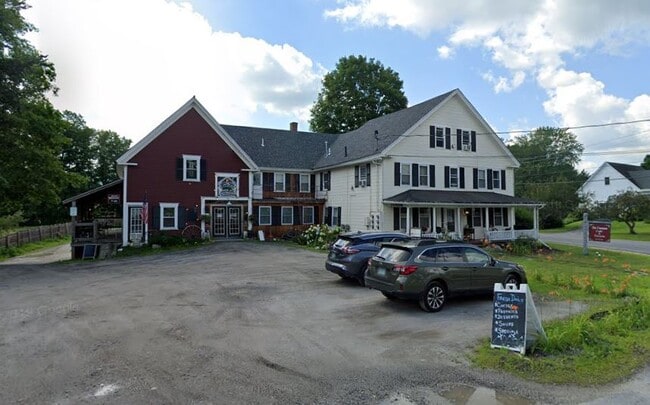

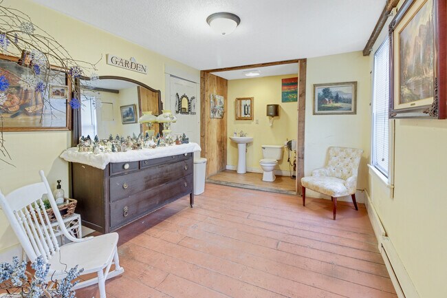
Property Detail
2 Quincy Rd
RUMN-000012-000000-005001
Grafton
Commercialbuilding
New Hampshire
VILLAG
5001
B and X Area of moderate flood hazard, usually the area between the limits of the 100-year and 500-year floods.
0.95 AC
2025
Concord/New Hampshire North Area
2025
Other Market Areas
960802
Lebanon-Claremont, NH-VT
6,966 SF
NEARBY LISTINGS FOR SALE OR LEASE
-
-
View all Rumney listings for sale on LoopNet.com
DEMOGRAPHICS near 2 Quincy Rd
1 mile
3 mile
5 mile
2025 Total Population
309
981
2,757
2030 Population
310
982
2,779
Pop Growth 2025-2030
+ 0.32%
+ 0.10%
+ 0.80%
Average Age
49
49
48
2025 Total Households
135
430
1,218
HH Growth 2025-2030
0.00%
+ 0.23%
+ 0.82%
Median Household Inc
$71,999
$65,625
$71,644
Avg Household Size
2.30
2.30
2.20
2025 Avg HH Vehicles
2.00
2.00
2.00
Median Home Value
$354,166
$356,578
$343,689
Median Year Built
1969
1969
1976
Nearby Places
Map Layers
Map Styles
 Street
 Aerial
Layers
 Traffic
 Biking
Places
Listings with unknown addresses are not visible on the map
- Restaurants
- Banks
- Shops
- Fitness
- Groceries
SALE & LEASE HISTORY
LISTING DATE
SALE/LEASE

Apr 09, 2021
For Sale
Nearby Properties
Address
Land Use
TOTAL SIZE
Lot Size
Zoning
Address
Land Use
TOTAL SIZE
Lot Size
Zoning
2,295.68 AC
RURAL
Address
Land Use
TOTAL SIZE
Lot Size
Zoning
4.70 AC
COMMER
Address
Land Use
TOTAL SIZE
Lot Size
Zoning
35,737 SF
7.16 AC
COMMER
Address
Land Use
TOTAL SIZE
Lot Size
Zoning
66.80 AC
COMMER
Address
Land Use
TOTAL SIZE
Lot Size
Zoning
18,284 SF
1 AC
RUMN B
Address
Land Use
TOTAL SIZE
Lot Size
Zoning
0.55 AC
VILLAG
Address
Land Use
TOTAL SIZE
Lot Size
Zoning
404 AC
RUR R
Address
Land Use
TOTAL SIZE
Lot Size
Zoning
47 AC
COMMER
Address
Land Use
TOTAL SIZE
Lot Size
Zoning
5,613 SF
16.02 AC
COMMER
Address
Land Use
TOTAL SIZE
Lot Size
Zoning
3,197 SF
RURAL
Address
Land Use
TOTAL SIZE
Lot Size
Zoning
0.34 AC
VILLAG
Address
Land Use
TOTAL SIZE
Lot Size
Zoning
6.38 AC
COMMER
Address
Land Use
TOTAL SIZE
Lot Size
Zoning
9 AC
RURAL
Address
Land Use
TOTAL SIZE
Lot Size
Zoning
6,945 SF
1 AC
VILLAG
Address
Land Use
TOTAL SIZE
Lot Size
Zoning
485 AC
RUR R
Address
Land Use
TOTAL SIZE
Lot Size
Zoning
1.38 AC
COMMER
Address
Land Use
TOTAL SIZE
Lot Size
Zoning
6,698 SF
1.16 AC
VILLAG
Address
Land Use
TOTAL SIZE
Lot Size
Zoning
2,424 SF
15 AC
RURAL
Address
Land Use
TOTAL SIZE
Lot Size
Zoning
4,664 SF
12 AC
COMMER
Address
Land Use
TOTAL SIZE
Lot Size
Zoning
3,233 SF
2.18 AC
VILLAG
Address
Land Use
TOTAL SIZE
Lot Size
Zoning
11.48 AC
COMMER
Address
Land Use
TOTAL SIZE
Lot Size
Zoning
Address
Land Use
TOTAL SIZE
Lot Size
Zoning
1,420 SF
32.46 AC
RURAL
Address
Land Use
TOTAL SIZE
Lot Size
Zoning
2,006 SF
41.43 AC
COMMER
Address
Land Use
TOTAL SIZE
Lot Size
Zoning
5,437 SF
2.80 AC
VILLAG
Address
Land Use
TOTAL SIZE
Lot Size
Zoning
2,932 SF
1 AC
VILLAG
Address
Land Use
TOTAL SIZE
Lot Size
Zoning
4,637 SF
13.90 AC
VILLAG
Address
Land Use
TOTAL SIZE
Lot Size
Zoning
2,592 SF
3.36 AC
COMMER
Address
Land Use
TOTAL SIZE
Lot Size
Zoning
4,522 SF
8.40 AC
VILLAG
The World's #1 Commercial Real Estate Marketplace
Connect with us
© 2026 CoStar Group
The information above has been obtained from sources believed reliable. While we do not doubt its accuracy we have not verified it and make no guarantee, warranty or representation about it. It is your responsibility to independently confirm its accuracy and completeness. Any projections, opinions, assumptions, or estimates used are for example only and do not represent the current or future performance of the property. The value of this transaction to you depends on tax and other factors which should be evaluated by your tax, financial, and legal advisors. You and your advisors should conduct a careful, independent investigation of the property to determine to your satisfaction the suitability of the property for your needs.